CK-12 Foundation
Topographic and Geologic Maps: Topographic Maps
Maps are great for helping you get where you're going, but what does that place actually look like? Geology scholars compare and contrast the features of topographical and geologic maps using an interactive lesson. The resource describes...
CK-12 Foundation
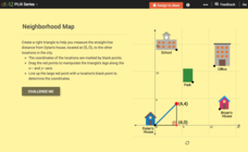
Pythagorean Theorem to Determine Distance: Neighborhood Map
Find the distance between various locations in a neighborhood. Scholars use the interactive to find distances between locations on a map. The map is overlaid onto a grid to provide coordinates for each location, and pupils apply...
CK-12 Foundation
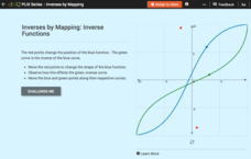
Inverses by Mapping: Inverse Functions
Map your way to successfully understanding inverse functions. Pupils use an interactive map to investigate how changes in the graph of a function affect the graph of its inverse. The results of the activity lead to the conclusion that...
CK-12 Foundation
Whole Number Multiplication: Multiplication Map
How many miles did a car travel if it traveled at 55mph for three hours? What are the factors for this multiplication sentence? These are the questions young mathematicians must solve using a multiplication map.
CK-12 Foundation
Direction on the Earth: Using a Compass
Navigate the world of orienteering in an informative interactive. Earth science scholars learn practical direction skills, such as proper polar coordinates and pairing compasses with maps. The interactive map allows them to practice...
CK-12 Foundation
Intersecting and Parallel Lines
Sometimes line segments just refuse to meet. Young mathematicians connect houses on an interactive map using line segments. They must then determine whether these line segment pairs are intersecting or parallel.
CK-12 Foundation
Identify Line Types: Intersecting and Parallel Lines
Navigate your way through a lesson on types of lines. Individuals drag line segments to illustrate paths between pairs of houses on an interactive map. They determine if these line segment pairs are intersecting or
parallel.
CK-12 Foundation
Midpoint and Segment Bisectors: Midpoint Map
Discover how to find a midpoint with a conceptual exploration. Scholars manipulate a point to determine the location of a midpoint on a straight line distance between two locations. Later questions extend to determine the...
CK-12 Foundation
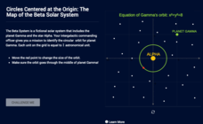
Circles Centered at the Origin: The Map of the Beta Solar System
Calculate galactic orbits in a far-out resource. Pupils drag a point on a circle to graph the orbit of a fictional planet. Using the equation, they find points through which the orbit passes. To finish the simulation, users determine the...
CK-12 Foundation
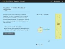
Equations of Circles: The Sea of Happiness
Map this! Help your young mathematicians draw a circular island on a map. Given specifics of the location and size of an island on a map, pupils transform a circle to meet the given requirements. They then determine the location of the...
CK-12 Foundation
Points in the Coordinate Plane
Map your way to success in understanding coordinate points. Individuals drag town landmarks to their appropriate locations on a coordinate plane representing a map. They answer a set of challenge questions to see if their answers are...
CK-12 Foundation
Location on the Earth: Longitude and Latitude
To what degree do learners understand coordinates? Get them some practice in Yosemite National Park in a simple, fun interactive. Pupils explore a map and locate coordinates of popular sights within the park, then answer questions...
CK-12 Foundation
Regular and Irregular Polygons: Polygon States
Colorado would probably object if Wyoming enlarged its borders. Scholars use an interactive map to change the borders of U.S. states to see how angles change. They then answer questions about regular and irregular polygons.
CK-12 Foundation
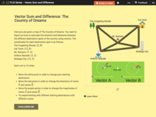
Vector Sum and Difference: The Country of Dreams
Find your way around using vectors. Scholars use an interactive to learn about vector addition. They answer a set of questions about modeling a route on a map using vectors.
Mr. Nussbaum
Battle of Fort Sumter
Fort Sumter, the site of the Civil War's first battle, taught the Union and the Confederacy an important lesson: they would both need to take stronger steps than anticipated if they wanted to win the war. History pupils read about the...
Stanford University
Stanford University Library: Hart Project
Explore the collection of 364 photographs which are plotted within this 3-D map experience recreating Alfred A. Hart's journey along the Central Pacific Railroad. The goal of his 1860s expedition was to solicit investment in the...
Colorado State University
Colorado State University Libraries: Garst Collection: Animal Geography
Interactive map for discovering which animals live on which continent.
University of Iowa
University of Iowa Libraries: The Atlas of Early Printing
View this interactive reference tool to learn about the history of printing in Europe during the fifteenth century. Features a map that displays layers of information that can be viewed together or individually along with a timeline of...
American Association of Physics Teachers
Com Padre Digital Library: Open Source Physics: Double Pendulum Poincare Map
A double pendulum model where the angles and angular velocities can be manipulated and the effects observed.
American Association of Physics Teachers
Com Padre Digital Library: Open Source Physics: Kicked Rotor Dynamics Model
Simulation analyzing the motion of a rotor that is repeatedly kicked. Adjust the settings for kick strength and speed and observe the results.
American Association of Physics Teachers
Com Padre Digital Library: Open Source Physics: General Relativity Schwarzschild
Visualization that uses the Schwarzschild metric, showing the orbit light travels near a black hole.
American Association of Physics Teachers
Com Padre Digital Library: Open Source Physics: Particle Worldline Model
Simulation exploring the behavior of particles as they approach a black hole using Schwarzschild coordinates.

