US National Archives
WWII: Mediterranean and N. Africa 1939-45 – Monty
Is Field Marshal Montgomery the right man to command the land forces in France for D-Day? That's the question facing young historians as they explore an interactive resource that focuses on the Mediterranean and North Africa theatre from...
Curated OER
Ancient Mediterranean Lands: A Timeline of Mediterranean Civilizations
Seventh graders create a timeline for the Mediterranean civilizations. In this Mediterranean activity, 7th graders make a living timeline for the Mediterranean civilizations.
Curated OER
Ancient Mediterranean Lands: Rome
Seventh graders research ancient Roman civilizations, trade routes, aqueducts, and agriculture. In this Ancient Rome lesson, 7th graders view a picture of the Roman Aqueduct Pont du Gard and discuss its use in ancient Rome. Students read...
Curated OER
Ancient Mediterranean Lands: A Timeline of Mediterranean Civilizations
Sixth graders explore world history by participating in a class agriculture activity. In this wheat weaving lesson, 6th graders identify the different Mediterranean regions that adopted early agriculture methods and expanded their...
Curated OER
Cargoes from Three Continents Ancient Mediterranean Trade
Sixth graders begin the instructional activity by researching the different types of ships and shipbuilding techniques used to help trade in the Mediterranean Sea. Using different objects, they determine what one can tell about a...
Curated OER
Ancient Mediterranean Lands: Greece
Sixth graders explore the processes developed by the Ancient Greeks, particularly olives and olive oil. In this Greek culture and inventions lesson, 6th graders read an article and design a flap book. Students collect the olive oil from...
Curated OER
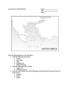
Ancient Greece Map Worksheet
Since the beginning of time, geography has shaped the development of human civilization, and ancient Greece is no exception. This instructional activity supports young historians with exploring this relationship as they first identify...
Curated OER
Mediterranean Lands: A Pilgrimage Through Time and Space
Students will use context clues and examine several maps to answer series of short answer questions over range of geographical topics, identify specific places, practice using GoogleEarth to compare satellite views to those produced two...
Curated OER
Trade in the Ancient Mediterranean
Young scholars begin the lesson by locating cities and other points of interest in the ancient world. In groups, they use the internet to research the types of ships used during this time period and discuss the reasons why trade was...
Curated OER
Ancient Mediterranean Lands: Greece
Learners study maps and structures of Ancient Greece and realize how these structures impact times. In this structures lesson plan, students view the structures of how Ancient Greece was put together and discuss how these structures...
Ms. Catsos
Ancient Rome Map Worksheet
It wasn't just the great leaders of ancient Rome that shaped their civilization—the geography of the region played a major role as well. After first identifying major land masses, bodies of water, and city states on a map of Europe,...
University of Pennsylvania
Canaan and Ancient Israel
Planning for your next activity on ancient Israel, but not sure where to start? Check out this assortment of activities to help get the ball rolling. It includes a range of ideas on topics, such as Greek and Egyptian mythology,...
Curated OER
Children's Crusade
In this geography worksheet, students read an excerpt about the Crusaders compromised of two of children. They use the map given to determine how far apart each army marched before reaching the Mediterranean Sea. In addition, students...
Curated OER
Land or Sea?
Sixth graders access a database to search for desired information, using "and" or "or" connectors where necessary. They choose a connector and search a prepared database of European countries to locate which countries border certain...
Curated OER
The Middle East: Land of Contrasts
Students explore the ancient city of Petra. In this Middle East lesson, students watch "The Royal Tour of Jordan," and then discuss the history of Petra. Students conduct research on selected sites in the city and use their findings to...
Curated OER
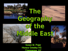
The Geography of the Middle East
Topographic, political, and satellite maps establish the world of the Middle East for your class- a land about which they have heard quite a lot, but might not really understand. This presentation would be a good introduction into a unit...
Curated OER
Forests of the World
In this forests worksheet, students read a one page informational excerpt on different forests throughout the world. They then use what they learned to answer the 20 questions on the worksheet. The answers are on the last page of the...
Curated OER
Monsoon Winds to the "Land of Gold"
Students recognize environmental factors that influenced maritime trade routes and the establishment of major trading centers in classical times. They evaluate perceptions of the ancient world through ancient maps and primary source...
Beverly Hills High School
Mapping Napoleon's Empire at Its Height (1812)
The complicated political history of Europe becomes apparent as young historians create a map of the borders of France when Napoleon's Empire was a its height in 1812.
Delegation of the European Union to the United States
The Geography of Europe
What is the European Union? Where is it? Why is it? To begin a study of the EU, class members examine the physical geography of Europe and the size and population density of 28-member countries in comparison to non-member countries like...
Cave Creek Unified School District
Crusades and Culture in the Middle Ages
The Crusades sounds like a glamorous time period in the Middle Ages full of glory—but was it? Scholars find and review the truth of the Crusades' influence on the world through the resource. The study guides, separated individually by...
Smithsonian Institution
Battle of the Bulge: America Responds to a German Surprise
World War II and the Battle of the Bulge are the focus of a history resource. Exercises include analyzing images, writing letters in the mindset of a soldier, and even immersing oneself in a cold experience to better empathize with the...
Global Oneness Project
Far From Home
A timely and provocative lesson inspires high schoolers to tackle the Syrian refugee crisis. They analyze a compelling photo essay before discussing and writing about it.
Education World
Every Day Edit - A Giraffe in Paris
In this everyday editing learning exercise, learners correct grammatical mistakes in a short paragraph about a giraffe walking to Paris. The errors range from punctuation, capitalization, grammar, and spelling.


