Curated OER
Dangerous Roads in Your Community
Students collect information about dangerous streets and intersections in community, interview law enforcement officials and safety experts to find out what they think can be done to reduce accidents, write in-depth article using these...
CK-12 Foundation
Points in the Coordinate Plane
Map your way to success in understanding coordinate points. Individuals drag town landmarks to their appropriate locations on a coordinate plane representing a map. They answer a set of challenge questions to see if their answers are...
Curated OER
Salt of the Earth: A Caddo Industry in Arkansas
Middle schoolers explore the history of the Caddo Salt Industry found in Arkansas. Along with learning about how salt deposits formed in Arkansas, learners study the process of salt production and how valuable salt is as a natural...
Curated OER
Australian Aboriginal Art and Storytelling
Young explorers investigate Australian Aboriginal culture by listening to traditional Dreamtime stories and examining dot paintings created by Aboriginal artists. In addition, they locate the country on maps, discuss the geography of...
United Learning
The Great Age of Exploration (1400-1550)
Delve into the Age of Exploration with this activity-packed resource! Complete with a pre-test, discussion questions and quiz for a 30-minute video on the period, map activities, timeline of discoveries, vocabulary, etc. this is a...
EngageNY
Grade 10 ELA Module 3: Unit 2, Lesson 1
Scholars work through an investigation process to narrow down a question to research. Learners begin by examining the research process, creating a portfolio, and vetting two or three possible topics. For extended work, they search for...
CK-12 Foundation
Location on the Earth: Longitude and Latitude
To what degree do learners understand coordinates? Get them some practice in Yosemite National Park in a simple, fun interactive. Pupils explore a map and locate coordinates of popular sights within the park, then answer questions...
CK-12 Foundation
Regular and Irregular Polygons: Polygon States
Colorado would probably object if Wyoming enlarged its borders. Scholars use an interactive map to change the borders of U.S. states to see how angles change. They then answer questions about regular and irregular polygons.
CK-12 Foundation
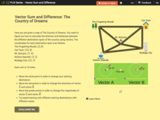
Vector Sum and Difference: The Country of Dreams
Find your way around using vectors. Scholars use an interactive to learn about vector addition. They answer a set of questions about modeling a route on a map using vectors.
ReadWriteThink
Biography Project: Research and Class Presentation
I Have A Dream ... that after the lesson, all individuals master the reading, writing, researching, listening, and speaking skills the biography project helps them develop. Martin Luther King, Jr. serves as a topic example for a model...
Curated OER
Then and Now
Students list the similarities and differences seen as they compare and contrast historical and current street maps of their local communities.
Curated OER
Piecing It Together!
Young scholars use clues to identify states on maps. They work together to identify the state a major city is in as well. They share their map with the class once it is completed.
Curated OER
Planning a Railroad
Students use a topographical map to plan a route from Doknner Summit to Truckee, then compare it to the route selected by Theodore Judah.
Curated OER
ESOL Government and Commmunity Resources
Students study vocabulary words associated with community services. They label each community service on an index card and match a phrase with the service. They identify community service buildings in the area on a local map.
Curated OER
Tallahassee Project
Sixth graders gather information from technological sources such as TV, radio, and Internet as well as from newspapers and maps and produce a final printed report. They use the data to create a spreadsheet and read a Florida state...
Curated OER
SAMMY DISCOVERS SHAPES AT SCHOOL
Students study maps and use them for real world experiences.
Curated OER
An Encounter of Former Foes
Students examine a timeline on the internet showing the relationship between the American Government and the Nez Perce in the 19th Century. After looking at the timeline and included map, students answer questions.
Curated OER
Africa
Second graders explore Africa. They label the popular places in Africa on a map. Students label the different cities and monuments that are popular in Africa. They discuss the similarities and differences between cities in Africa and...
Curated OER
Social Studies
Third graders explore maps and models. They discuss communities and the buildings within their community. Students construct a model of the downtown area of their town. They construct a map of their town and write facts about the...
Curated OER
Sorting the Loyalist Documents
Students organize the Canadian Loyalist primary source documents and add more information to their primary source document concept maps.
Curated OER
Pioneer Trails and Towns
Third graders research pioneer trails to discover how they have changed. In this pioneer trails and towns lesson, 3rd graders identify trails on a map and gather information on how those trails are now major roads and highways along town...
Curated OER
U.S. Geography: The Northeast
Students investigate U.S. Geography by creating a map in class. In this natural resource lesson, students create a map of the United States and research the Northeast based on their resources and recyclable materials. Students...
Curated OER
Asking For Directions
Learners draw a map of their surrounding area using appropriate landmarks and identifying characteristics. Students ask for and give directions to locations found on their maps to their partner. This lesson is intended for learners...
Curated OER
The Marvelous World of OZ
Students investigate the major themes in fantasy maps, expand basic map reading skills, write imaginative narrative essays based on the OZ map, and create their own fantasy map detail based on a core map.


