Curated OER
Decimal Multiplication
Students use base ten blocks to lead them in the concept of understanding multiplying numbers with decimals. In this multiplication of decimals lesson plan, students also use digital activities to help them with the multiplication.
Curated OER
Map Maker Map Maker
Students create their own maps. In this map making lesson, students go to Microsoft Word and create a chart. They label directions, buildings, streets, and distance.
Agriculture in the Classroom
A Holiday Tradition: Which Christmas Tree Will You Choose?
Different varieties of Christmas trees provide an interesting way to combine social studies, science, math, and technology. Class members not only research the history of the Christmas tree holiday tradition, they compare and...
EngageNY
The Inverse Relationship Between Logarithmic and Exponential Functions
Introducing inverse functions! The 20th installment of a 35-part lesson encourages scholars to learn the definition of inverse functions and how to find them. The lesson considers all types of functions, not just exponential and...
National Nanotechnology Infrastructure Network
What’s In Your Neighborhood?
Chart your way to an understanding of nanoscale. Using a Google map, learners estimate a radius around their location of 1,000 and 1,000,000 meters. Predicting what 1,000,000,000 meters would look like takes them off the charts!...
Curated OER
Pictures of Data
In this data worksheet, learners look at maps and charts and answer multiple choice questions about them. Students complete 10 questions.
Mathematics Assessment Project
Middle School Mathematics Test 3
Real-life mathematics is not as simple as repeating a set of steps; pupils must mentally go through a process to come to their conclusions. Teach learners to read, analyze, and create a plan for solving a problem situation. The...
Mathematics Assessment Project
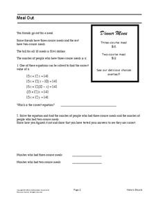
Meal Out
Middle schoolers identify an equation in one variable that models a restaurant order. They then solve the equation to determine the number of people who had each type of meal.
Curated OER
The Prairie Climate
Ninth graders research the average temperature and precipitation of a prairie region to determine the type of climate it is, and how it differs from other biomes. They examine the types of adaptions animals have made to live in the...
EngageNY
Mid-Module Assessment Task: Grade 8 Module 2
It's time for a concept check! Check for student understanding over the three types of rigid transformations. The assessment follows the first 10 lessons in this series and to test pupils' proficiency of these concepts. Individuals...
Houghton Mifflin Harcourt
Unit 5 Math Vocabulary Cards (Grade 4)
A set of 49 cards can enhance fourth graders' math vocabulary. It provides a pair of cards on each sheet, one with the word printed in bold text, and the other with the definition of the word. Topics of the cards include mostly...
Concord Consortium
School Bus Routes
Plan the way to school. Given a map of a school district, class members portray a transportation consultant hired to develop a bus transportation plan that will pick up the eligible riders and get them to school. The plan must contain...
Curated OER
Scale Factors
In this scale factors worksheet, 6th graders solve 10 different problems that include types of scale factors. First, they determine the missing dimensions in each problem. Then, students round their responses to the nearest tenth before...
Curated OER
Scale Drawing
In this scale drawing worksheet, 10th graders solve 10 different word problems that include various types of scale drawings in each. First, they determine the length of a highway on a map. Then, students determine the dimensions of a...
Curated OER
Places and Production
Students calculate United States GDP and GDP per capita, use a choropleth map to acquire information, and create choropleth maps of GDP per capita in South America. They identify regions with high and low GDP per capita
Curated OER
Mapping A Stream
Students participate in mapping an actual waterway. They include reach lengths, transects, compass reading, and scale determinations. They include windfalls, plant cover, types of streambed composition, and landmarks such as trees and...
Curated OER
Comparing School Bus Stats
Engage in a lesson that is about the use of statistics to examine the number of school buses used in particular states. They perform the research and record the data on the appropriate type of graph. Then they solve related word problems.
Curated OER
Investigation 9 - Bird Study
Fourth graders examine specific bird characteristics and become more aware of the ecosystems that support each bird. They engage in bird walks, mapping the areas where they find evidence of bird activity.
Curated OER
Money
Third graders review the values of quarters, dimes, nickels, and pennies. They discuss how the different types of coins can equal the same amount. Students give examples of ways to make a given amount under $1.00. They explain what the...
Curated OER
Let's Take a Trip!
Sixth graders plan a trip for a family of four choosing their travel plan by studying maps to decide upon a route and visiting Websites to get airline and travel schedules. They use ratios and proportions as well as converting fractions...
Curated OER
Triangles
In this triangles worksheet, 10th graders solve and complete 23 various types of problems. First, they match the triangle description with the most specific name and write the letter on the line provided. Then, students classify the...
Curated OER
Geometric Transformations
Learners examine images and preimages of a mapping and identify isometry. They view images by M.C. Escher, observe teacher demonstrations, and create a translation image, a rotation image, and a dilation.
Curated OER
Shadows and Skyscrapers
Eighth graders explain the relationship between the position of the sun, a city's latitude and shadow length. Ratio's, geometry, and algebra are used to determine the shadow lengths and building heights. A sun angle (altitude) charts to...
Curated OER
Scale Drawing
In this measuring lengths worksheet, students determine which units to use when measuring lengths, estimating lengths, and the errors made when measuring, Students estimate the lengths of each of the lines illustrate to the nearest unit....
