Polar Trec
Playground Profiling—Topographic Profile Mapping
The Kuril islands stretch from Japan to Russia, and the ongoing dispute about their jurisdiction prevents many scientific research studies. Scholars learn to create a topographic profile of a specific area around their schools. Then they...
Teacher Printables
Concept Map
Prepare your class for a unit by introducing them to the main ideas and topic that will be covered. While you explain the concepts, have your class fill out this graphic organizer, which provides space to write in a topic and six related...
Curated OER
Customized Topographic Maps and Models
Students explore the information depicted on topographic maps. They construct a 3-D topographic map of a local area. They go on a field trip to the depicted area and compare the 'real world' with their models.
Kate Stickley
Reading the World: Latitude and Longitude Lesson latitude and longitude, maps, coordinates on a map, prime meridian, reading maps, equator, globes
Find five activities all about longitude and latitude! Use oranges to show the equator and prime meridian, plot birthdays on a map using coordinates, and plan a dream vacation.
Curated OER
Maps and Modes, Finding a Mean Home on the Range
Fifth graders investigate data from maps to solve problems. In this data lesson, 5th graders study maps and collect data from each map. Students present their data in a variety of ways and calculate the mode, mean, median, and range.
National Geographic
Mapping the Shape of Everest
With Mount Everest as the motivator, your earth science class learns about topographic maps. Begin by showing a film clip from The Wildest Dream: Conquest of Everest, featuring fearsome virtual imagery of a path up world's tallest peak....
Baylor College
Mapping the Spread of HIV/AIDS
Where is HIV/AIDS most prevalent and what are the current trends regarding HIV? Have groups work together to map the world's HIV/AIDS rates, then create a class map with all the data. Lesson includes cross-disciplinary concepts including...
Cedar Ridge Elementary
Thinking Map Templates
Help your class understand and organize concepts, facts, ideas, and events with a set of graphic organizers and flow charts. Included in this packet is a bridge map, multi-flow map, flow map, double bubble map, bubble map, circle map and...
Curated OER
What Do Maps Show?: Lesson 1 Introduction to Maps
Students brainstorm a list of the different types of maps they have seen or used. Using the activity sheet, they look through a social studies book to find all the maps and to determine what they are used for. Using a poster, they review...
Curated OER
Orienteering - Lesson 1 - Maps & Map Scales
Lesson 1 of 10 lessons in this orienteering unit is about maps and map scales. After all, orienteering is all about maps, compasses, and finding ones' way around. It is imperative to be able to read maps and understand the relevance of...
Curated OER
Just Draw Me a Map!!!!
Middle schoolers draw a map to give directions to someone rather then give them too many relative locations.
Curated OER
Mapping America
While learning about the Louisiana Purchase, pupils practice map skills. This motivating lesson has them answer questions about the Louisiana Territory and the United States. It provides a quick and easy way review of skills and the...
Curated OER
Using the Landscape Picture Map to Develop Social Studies Skills
Enhance your class' geography skills using this resource. Explore a variety of concepts including production and distribution, and people and the environment. Learners make predictions and identify locations on maps. This is a creative...
Perkins School for the Blind
Beginning Map Skills
Maps can be so much fun, they help you understand spatial relationships, distance between objects, and can foster direction skills. Budding cartographers with visual impairments use the Wheatley Tactile Diagramming Kit to create their...
Curated OER
How To Make a Science Concept Map
Here is a clever way to get your pupils thinking about a science topic they'd like to research for a report, or a project they'd like to do for a science fair. The three-step process is easy to follow, and it really should help your...
Curated OER
Science Concept Maps
A collection of concept maps has some terms filled in and others left blank for young scientists to fill in. This library can provide you with many pop quizzes for all of your middle to high school science curriculum.
Curated OER
Exploring Arizona's Biotic Communities Lesson 1: Mapping Biotic Communities
As part of a unit on Arizona's biotic communities, young ecology learners create a map. They describe how humans and animals adapt in their habitat. They take notes and create graphic organizers from articles they read. Beautiful maps,...
Curated OER
Unit II Worksheet 4 - Constant Velocity/Motion Maps
This is a smart approach to displacement concepts. Physics learners analyze a motion map and then draw qualitative graphs for time versus displacement and time versus velocity. Get your class thinking critically through the use of a very...
Curated OER
Unit II: Worksheet 5 - Velocity and Motion Maps
A chart with eight rows makes up this handout. The columns are labeled with two graphs ("x vs. t" and "v vs. t"), a written description, and a motion map. One cell in each row is filled in, leaving the rest for your class to complete....
PBS
Concept Map
Make the thought process visible with a handy concept map organizer. As learners develop their main ideas in research, writing, or creative development, they can add details and like ideas to the worksheet as needed.
CK-12 Foundation
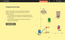
Pythagorean Theorem to Determine Distance: Neighborhood Map
Find the distance between various locations in a neighborhood. Scholars use the interactive to find distances between locations on a map. The map is overlaid onto a grid to provide coordinates for each location, and pupils apply...
Curated OER
Geography Awareness Week: Practice Mapping Skills
You won't get lost, after learning map skills during Geography Awareness Week.
Do2Learn
Brainstorming Map Array
Getting ideas down on paper is often the first step when starting a project or new unit of study. Try out this straightforward brainstorming map with your class. Learners write in a topic and use the six bubbles that branch out of the...
Curated OER
Soil: Food Mapping
Students examine the concept of food mapping . In this agriculture lesson, students explore food and agriculture systems in the United States in the past and today. Students complete food mapping activities.


