McGraw Hill
Study Guide for Bridge to Terabithia
Bridge to Terabithia is a story about friendship that brings magic into ordinary life. Study guides may not be magical, but the guided questions, graphic organizers, extension activities, vocabulary, and discussion questions help...
Curated OER
Project Whistlestop:Missouri Vacation Learning Unit
Fourth graders reserach the state of Missouri. In this Missouri History lesson, 4th graders plan a vacation to a region of Missouri. Students work in collaborative groups to determine all aspects of the trip. Students use math...
Curated OER
Mapping the Census
Students learn why the census makes a difference. In this U.S. Census lesson plan, students learn the key elements of cartography, examine the difference between data and their representation, and create a map using census data.
Population Education
Population Map
Here is a very interesting graphic of a world map where each country's size is adjusted accordingly to its population. The bottom row of the document also includes several maps depicting the major shifts and growth of the world...
Alabama Learning Exchange
Coordinate Geometry
Where do the coordinates lead? As children brainstorm ways to find the location of different buildings, they learn about coordinate points and how to use them to locate areas on a grid or map. They practice using ordered pairs by playing...
Curated OER
Walk Two Moons: Discussion Web
Is Phoebe a good friend to Sal or not? After reading chapters twenty-five and twenty-six of Walk Two Moons, class members use the provided graphic organizer to develop an argumentative piece. Writers must decide if the two...
Curated OER
China Quest
Read and research information on China. Young researchers complete a knowledge hunt about China then locate and describe each location using directional words. They recognize the word meaning through context clues and application practice.
Constitutional Rights Foundation
Sam Houston: A Study in Leadership
Learners read a short excerpt from a speech by Sam Houston and answer corresponding questions as well as engage in additional activities, including writing a persuasive essay and discussing topics in small groups. The resource helps lay...
Curated OER
What Do Maps Show?: Lesson 4 How to Read a Topographic Map
Learners examine the use of topographic maps as two dimensional representations that show elevations and slopes with contour lines. They read maps of the Salt Lake City, Utah area and complete the associated worksheets that show map...
Orlando Shakes
The Great Gatsby: Study Guide
Uncover the exciting world of the Roaring Twenties with The Great Gatsby study guide. Individuals become critics as they write a review of the production. Scholars also read historical information and analyze the differences between the...
Curriculum Corner
Fairy Tale Unit of Study
What makes a fairy tale a fairy tale? Use a 27-page packet to supplement your next fairy tale unit. With sequencing activities, story map worksheets, character analyses and story elements graphic organizers, and fairy tale highlight...
Penguin Books
Teacher's Guide: Where the Crawdads Sing by Delia Owens
An 11-page teacher's guide that focuses on Delia Owens' bestseller Where the Crawdads Sing is packed with discussion questions and activities. Text-dependent questions, activities, and writing prompts are also included....
National Geographic
The Monsoon
Few things are as fascinating as the challenge of climbing Mount Everest. This lesson investigates how monsoon weather impacts climbers. To begin, you are instructed to show various video clips. The only one directly provided, however,...
Curated OER
Mapping Perceptions
Students create and read maps. In this map skills instructional activity, students draw a map of their neighborhood, then use skills acquired during map-making to interpret a classmates map and a map of the Ming Dynasty.
Curated OER
Lesson 2: Mapping Our Home
Students recognize the importance of community participation in the census. In this U. S. Census lesson plan, students use map-reading skills to find answers and learn the difference between senators and members of Congress.
Curated OER
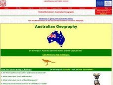
Australian Geography
In this map reading instructional activity, students label a map of Australia by adding the names of states and cities. They answer eight questions about the map.
Curated OER
Where Am I: How to Read a Map
Third graders develop an understanding of maps. They explore what a map is, who uses maps, and how to use maps. Students investigate the compas rose. They create a compose rose which illustrates the cardinal directions. Students practice...
Curated OER
Learning About Maps
Students take a "field trip" with the teacher through the school then draw a diagram of what they saw. They bring the maps to the computer lab where they create electronic maps using the software program Neighborhood Map Machine.
Curated OER
Topographic Mapping Skills
In this geography worksheet, students read an excerpt about topographic maps and why they are useful for various jobs. They also respond to eleven questions that follow related to the excerpt and locating specific map points on the map...
Curated OER
Way to Go! Create a Road Map Game
Young scholars create a travel game of one of the United States. They research a state of their choice and create a travel game using a common road map. They interpret map symbols as they calculate map mileage for their games. They...
National Geographic
Australia, Antarctica, and Oceana
Go on a traveling adventure throughout Australia, Oceana, and Antarctica! This textbook excerpt offers a full unit of study that can easily be supplemented by extra projects or research materials. Learners study maps, read about...
Illustrative Mathematics
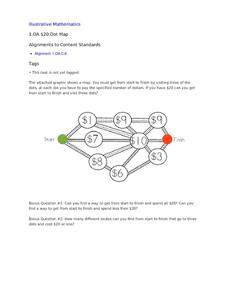
$20 Dot Map
Challenge the addition skills of young learners with this open-ended math problem. The task is simple, get from start to finish by connecting a series of three numbers. The trick is that the sum of the numbers must be less than...
EngageNY
Reading the Map and Beginning Chapter 1
Seventh graders begin their study of Linda Sue Park's A Long Walk to Water by discussing scenarios related to the novel with a partner. The discussion topics invite pupils to consider how various factors, such as war and poverty,...
PBS
Arthur Compass Rose
Keep your class headed in the right direction with this printable compass rose. Large and easy to read with a smiling picture of Arthur in the middle, this resource would make a fun addition to the desk of any primary grade...


