Seterra
Northern Europe: Countries - Map Quiz Game
Remembering geography is a tiring and tedious task to many scholars. Change it up by assigning the map quiz game. Elementary and middle schoolers alike test their knowledge and compete with the clock to match as many countries as...
Curated OER
The Country of Peru
For this Peru worksheet, students label places in Peru and draw, trace, and color parts of the country as well. Students complete 11 activities.
Richmond Community Schools
Map Skills
Young geographers will need to use a variety of map skills to complete the tasks required on this worksheet. Examples of activities include using references to label a map of Mexico, identify Canadian territories and European...
Curated OER
Countries and Nationalities
In this countries and nationalities worksheet, students fill in the blanks to sentences, complete a word search, label flags, and more. Students complete 6 activities.
Curated OER
Euro-Tourism
High schoolers design a tourist brochure using Publisher. They research an assigned European country. Students describe tourist attractions in their country and other interesting characteristics.
Curated OER
Clothes World: Beginning ESL lesson
Take a tour around the world with this ESL presentation about international clothes. From South African tribal wear to Scottish kilts, your English learners will appreciate the vivid pictures and clear country labels for each slide. The...
Curated OER
Land or Sea?
Sixth graders access a database to search for desired information, using "and" or "or" connectors where necessary. They choose a connector and search a prepared database of European countries to locate which countries border certain...
Curated OER
Food and Countries Match
Beijing duck? Italian pizza? Japanese sushi? Language learners match food words with their country of origin. An answer key is included with the colorfully illustrated worksheet.
Curated OER
A World of Information
Students analyze data and statistics about countries around the world. They read graphs and charts, color a world map to illustrate the top ten statistics about the world, and write a paragraph to summarize their information.
Curated OER
Folk Dances from Spanish Speaking Countries
Students explore dance activities from three different Spanish speaking countries.
Curated OER
Geography/Current Events Project
Using the Balkan region as an example, fourth graders review the five themes of geography as a class. They identify the physical and human characteristics of a region before labeling the countries and landforms on a map. They then...
Curated OER
El Mundo Hispano
Colorful maps are clearly labeled in this PowerPoint to show viewers where different Hispanic countries are located within Central and South America. Each country is listed on its own slide with a title, the capital, close-up map, flag,...
Curated OER
Country Capitals
Learners locate country capitals on a world map. In this map skills lesson, students review the definition of the word country and discuss what a capital is. Learners locate and label capital cities on a world map using a map marker.
Curated OER
Philippines- Neighboring Countries & Water Boundaries
In this Philippines worksheet, students answer multiple choice questions and label the diagram with neighboring countries and water boundaries. Students complete 16 questions.
Curated OER
The Country of Chile - Map Work
In this map worksheet, students label a map of Chile by following 11 directions given at the bottom of the page. They label landforms and water bodies associated with the country.
Curated OER
Africa Outline Map: Labeled
In this Africa outline map worksheet, students explore the political boundaries of the continent of Africa the countries located there. Each of the nations is labeled on the map.
Curated OER
Country Capitals
Students define the meaning of country capital. In this country capital instructional activity, students identify the symbol and find country capitals. Students locate and label capital cities on a map and insert the capital symbol.
Curated OER
Countries of the World
Students in a ESL classroom examine a world map and study the various countries' names. The study the cultures of selected countries and create a vocabulary list. Finally they label an empty map with the countries' names and a short...
Curated OER
The Country of Kenya
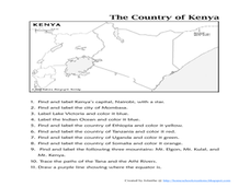
In this map completion worksheet, learners observe a map and map scale of Kenya to find and label bodies of water, cities, countries, and the equator. Students answer 11 questions.
Curated OER
The Country of Venezuela
For this map skills of Venezuela worksheet, students use an outline map to find an label important cities landforms, and bodies of water. Students label and color code 10 answers.
Curated OER
Bizarre Food
Students research foods from other countries. In this multicultural food lesson, students view a list of foods that kings and queens ate on an overhead transparency and go to the website www.jamessolheim.com/teachers1.htm to read about...
Curated OER
Africa Unite!
Students work in pairs to research assigned African countries. They compile their research to label a continent map of Africa, present their research to the class and design a game of trivia using their findings.
Curated OER
What City and Country
In this city and country worksheet, students analyze 6 labeled pictures of world landmarks. Students write the name of the city and country where they are located. Example: Eiffel Tower, Opera House, Great Wall, Colosseum.
Curated OER
Changing the Different Currency of Different Countries
Students change the money used in different countries into our currency. In this algebra lesson plan, students rewrite word problems using variables and inequalities. They label each unknown with a letter and identify the steps needed to...


