Curated OER
Map Coordinates: Monkey Map
Here's an engaging, meaningful, and clever lesson on map skills for elementary schoolers. Pupils combine story writing with mapping skills to create an original piece of work. They utilize a worksheet embedded in the plan to guide them...
CK-12 Foundation
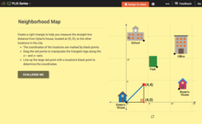
Pythagorean Theorem to Determine Distance: Neighborhood Map
Find the distance between various locations in a neighborhood. Scholars use the interactive to find distances between locations on a map. The map is overlaid onto a grid to provide coordinates for each location, and pupils apply...
Curated OER
Map Your School
Learners participate in a project to map their school. They measure and graph various areas around the school. Young scholars find the longitude and latitude of the school and research the school's history, and highlight special...
Teach Engineering
What is GIS?
Is GIS the real manifestation of Harry Potter's Marauders Map? Introduce your class to the history of geographic information systems (GIS), the technology that allows for easy use of spatial information, with a resource that teaches...
Curated OER
Planning a Garden Using a Grid
Third graders plan for a garden. In this garden planning lesson plan, 3rd graders investigate the use of a grid to accurately map out and plan for a vegetable garden. Students predict the space requirements for different vegetables.
Teach Engineering
What's Wrong with the Coordinates at the North Pole?
Here is an activity that merges technology with life skills as individuals use Google Earth to explore the differences between coordinate systems and map projections. The self-guided worksheet is the fourth segment in a nine-part unit....
Curated OER
Grid Frame Mapping
Students map and describe small area of the schoolyard and discuss habitats.
Curated OER
Important Decisions Don't Just Happen! Using Data to Plan Your Services
Students interpret statistics. In this data instructional activity, students examine and organize given data. They present the data in a grid format. Using the census data, students determine the best location for a...
Edgate
Great Grids
Learners use grid boxes as a measurement tool and discover how grids are used for mapmaking and scaling down an area. They begin by attempting to draw a model shape drawn by the teacher by using the gridding process. At the conclusion of...
Curated OER
Distances on Coordinate Grids
In this grid worksheet, 5th graders use a grid map with coordinate points to answer six questions regarding distance between locations.
Curated OER
Mapping the Bone Field: An Area and Scale Exercise
Here is an excellent cross-curricular lesson. Learners relate multiplication to area by making a grid on graph paper, and then creating the same grid in real space outside in the school yard.
Curated OER
Map Grids
Students study map grids and explore how they can be used to locate positions of objects or features on a map. They read a story and then participate in a grid activity using a large map of the setting of the story.
Curated OER
Goldilocks and the Coordinate Grids
Where this lesson idea is lacking in materials, it makes up for with creativity! Using "Goldilocks and the Three Bears" as the background, mathematicians plot points on a coordinate grid to create props for the story. The polygons all...
Curated OER
Mapping a Site Using a Coordinate Plane
Learners map their playground as if it were an archeological site. They locate objects on the playground and determine their location using coordinate points. A related lesson is Coordinate Grid: Mapping an Archeological Site.
Illustrative Mathematics
Latitude
The greater the latitude, the less of the Earth is north. Scholars graph the relationship between the latitude and the percentage of the Earth that is north of the latitude. Using the graph and the table, class members interpret values...
EngageNY
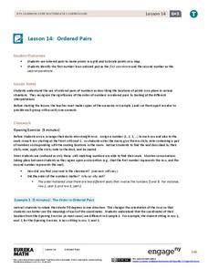
Ordered Pairs
Scholars learn to plot points on the coordinate plane. The activity introduces the idea that the first coordinate of a coordinate pair represents the horizontal distance and the second coordinate represents the vertical distance.
Curated OER
Draw an Inch, Walk a Mile
Students work in small groups to solve the problems presented. The main project, mapping the classroom, use these discussions to collaborate in creating a tangible demonstration of their understanding.
Curated OER
Coordinate Grid: Mapping an Archaeological Site
Middle schoolers examine how archaeologists preserve context of sites through use of rectangular grid or Cartesian coordinate system, and develop sense of distance by pacing off and estimating distances.
Curated OER
Explore Surface Types on a Journey Around Earth
Students explore satellite data. In this technology cross-curriculum math and world geography lesson plan, students locate specific map areas using a microset of satellite data. Students use technology and math skills to determine...
Teach Engineering
Who Can Make the Best Coordinate System?
Working with a map that does not have a coordinate system on it, small, collaborative teams must come up with a coordinate system for their map. Groups then explain their coordinate structure to the class.
Curated OER
Locating IIT Using Ordered Pairs
Students investigate ordered pairs. In this math activity, students plot and locate ordered pairs in a coordinate plane and are exposed to how to read and create a map.
Curated OER
Exploring Perimeter
Students explore perimeter. In this geometry and measurement lesson plan, students create squares and rectangles using given perimeters. Students construct four sided shapes with given perimeters using the computer program "Math Keys:...
Curated OER
Locating Places - Making a Map Grid
Students learn how to use a letter and number map grid. In this map grid lesson, students look at a landscape map and describe how to locate the airport. They compare the descriptions of different students to determine how they are the...
Curated OER
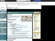
Grids
Take your study of coordinates online! Groups of students complete an online graphing introduction, plotting the points of virtual objects. A worksheet is included for extra practice.


