K12 Reader
United States Geography
Encourage reading for information with a text about United States geography. Kids read a short passage about the landforms in the United States, including mountain ranges and natural resources, and answer five reading comprehension...
Ed Helper Clip Art
USA States
Looking for a map of the Unites States of America? Look no further than this printable map designed to accompany your geography instruction and to give map skills a boost.
Curated OER
Landforms and Resources of the United States and Canada
In this North American geography activity, students read about the physical features and resources of the United States and Canada. Students take notes and answer 3 short answer comprehension questions as they read the selection.
Curated OER
The United States and Canada: Climate and Vegetation
Display U.S. and Canadian climate and vegetation through this text-companion worksheet. Learners read about the geography of these regions, take notes, and answer 3 comprehension questions as they read the selection. A graphic organizer...
Little 10 Robot
Geography Drive USA™
A trivia-style virtual road trip in which the player's car is moved from state to state as questions are correctly answered. Ideally, a player would learn about different states by reading the simple brochures available in the...
Curated OER
United States Regions
In this United States political map instructional activity, students examine regional census boundaries of the US. State boundaries are also included.
University of Richmond
Canals 1820-1860
While canals are not a common mode of transportation today, they were part of the fuel for America's industrialization. However, most of them were located in the North, also feeding regional differences and sectionalism. Using an...
CK-12 Foundation
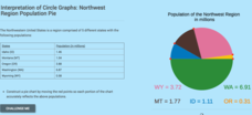
Interpretation of Circle Graphs: Northwest Region Population Pie
Given populations of the five Northwestern states, learners create a circle graph. Using the data and the pie chart, they make comparisons between the populations of the states. Finally, the pupils determine how the chart will change...
Curated OER
United States of America
In this writing instructional activity, students read short paragraphs about United States facts. Students then generate questions about the paragraphs using given facts.
Curated OER
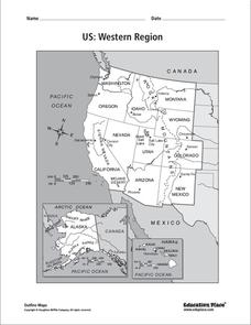
US: Western Region Map
For this United States Western Region worksheet, students examine the state boundaries and landforms found in this region. The map also highlights each of the state capitals.
Curated OER
Southern States Word Search
Sixteen of our southern states are hidden in this basic word search. Learners must find words that are hidden in every way possible within the search - even backwards! Luckily, an answer key does accompany this resource.
K12 Reader
National Symbols
What are the most prominent symbols of the United States? Learn about the bald eagle, the American flag, and the Statue of Liberty in a reading comprehension activity that includes a short passage and five reflective questions.
US Institute of Peace
Simulation on Conflict Prevention in the Greater Horn of Africa
Is containing a conflict possible in the Horn of Africa? Young peacekeepers engage in a simulation that examines the multi-faceted conflict that exists between the countries of Ethiopia and Eritrea. Representatives from ten countries in...
Curated OER
U.S. Geography for Children: State Capitals
In this United States map skills worksheet, students locate and label specified states and their capitals, and create icons and a map key to show something for each state that is famous. Students answer 5 questions.
University of California
The Civil War: Strategies and Battles
Was it the War against Northern Aggression or the War to Unify the Union? Scholars investigate the key battles and strategies of the American Civil War to determine just why the North was victorious in the end.
Curated OER
Pennsylvania Vocabulary Word Jumble
For this Pennsylvania worksheet, students unscramble the letters in 20 words to spell key cities, people, resources or regions in the state of Pennsylvania. There is a word bank.
Humanities Texas
Primary Source Worksheet: George Washington, Farewell Address
Invite your young historians to consider how the first president of the United States envisioned the future of the new nation with this primary source analysis worksheet on George Washington's Farewell Address.
Curated OER
State Cards
In this state cards worksheet, students cut out 9 cards, each of which has a picture of one state in the United States on it. These states are all located in the Midwest and Northwest regions. These cards could be used for a matching game.
National Wildlife Federation
Hot, Hotter, Hottest: Extreme Weather's Impact on Our Resources
How dry is it? It's so dry, the river only runs twice a week! Through an analysis of maps and discussions, pairs learn about droughts across the United States in the ninth of 12 lessons. They then read about, answer questions, analyze...
Artisan Global
QuakeFeed Earthquake Map, Alerts and News
Amateur seismologists explore Earth's earthquakes in real time using a variety of map styles and parameter selections.
Curated OER
Climate Change in Canada
In this Canada worksheet, students read a 6 page detailed informational text about climate change in Canada. Students then complete 10 essay/short answer questions.
Curated OER
Eastern States Word Search
In this geography word search worksheet, students locate and circle the 13 states located in the Eastern region of the United States. A word bank is provided.
Curated OER
Western States Word Search
In this geography word search instructional activity, students locate and circle the 11 states located in the Western region of the United States. A word bank is provided.
Curated OER
New Mexico
In this New Mexico worksheet, students read a two page text about the history of the state of New Mexico. Students answer ten true and false questions.


