Curated OER
Lines of Symmetry
First graders create symmetrical designs using a computer program. In this lines of symmetry lesson, 1st graders review their symmetrical designs and discuss other ways symmetrical designs can be made. Students work in pairs...
Curated OER
LRO and the Apollo-11 Landing Site
In this Apollo-11 landing site worksheet, students read about the NASA Lunar Reconnaissance Orbiter (LRO) that will collect images at a higher resolution than ever before. Students study a grid showing the lunar landing site from Apollo...
Curated OER
Where is it?
Students use a coordinate grid. They investigate and discuss what caused certain objects to be in specific places. They choose a room in their home to map and place objects in specific locations.
Curated OER
Perimeter Patterns
Sixth graders calculate perimeter of rectangles with different dimensions. In this perimeter activity, 6th graders define length, width and perimeter. Students complete a perimeter activity using a web tool to change the...
Curated OER
Park Brochures
Sixth graders investigate natural environments by researching national parks. In this brochure making lesson, 6th graders explore a specific national park and research it's information by utilizing the web. Students create travel...
Curated OER
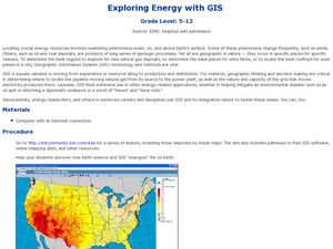
Exploring Energy with GIS
Learners examine GIS technology as it is used to locate energy sources. For this GIS lesson, student access an assigned website to locate a series of lessons using the GIS software. They use the maps that are located on the primary...
Curated OER
IBEX Creates an Unusual Image of the Sky!
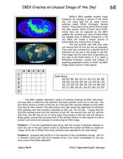
In this IBEX satellite worksheet, learners read about the Energetic Neutral Atoms that are detected by the IBEX satellite. Students use a given hypothetical data string to determine the number of particles detected and create an 'image'...
Curated OER
Where in the World...?
Students use longitude and latitude to locate various cities, regions, landforms, and bodies of water around the globe. They use The New York Times Learning Network's crossword puzzle 'Longitude and Latitude' to sharpen their atlas skills.
Curated OER
Dot to Dot: Patterns in the Night Sky
Sixth graders are introduced to several major constellations and locate them in the night sky. They graph the constellations on grid paper and work in groups to research common myths and stories associated with specific constellations.
Curated OER
Cherishing the Water of Life
Learners work in small groups to brainstorm a list of all creatures, plants, natural, and artificial processes that use or depend on fresh water. The class views an aquarium filled with water representing all the water in the world. The...
Curated OER
Marine Archaeology
Learners examine marine archaeology. In this archaeological data lesson, students see how archaeologists use data to make inferences about shipwrecks. Learners read data and make their own inferences, write about marine life and...
Curated OER
Siting Wind Power
Young scholars analyze a variety of curves that describe the power extracted from the wind by a variety of commercially produced wind turbines. They utilize site specific topographic maps and political boundary data to evaluate and make...
Curated OER
Lewis and Clark: Prized Possessions
Students consider the role of Sacagawea as part of the Corps of Discovery. In this Lewis and Clark expedition lesson, students discover details about Sacagawea's wampum belt and then create their own wampum belts using their computer and...
Curated OER
More Than One Grain of Rice
Learners explore mathematics, geography and agriculture by studying world rice production. In this production of rice instructional activity, students read One Grain of Rice and use a worksheet grid to calculate how much rice was...
Curated OER
Sunken Slave Ship
Students investigate shipwrecks. For this marine archaeology lesson, students create the site of a shipwreck by using a tub filled with sand and items from a "ship". Students excavate the site and analyze the findings.
Curated OER
Coordinates
In this coordinates worksheet, students analyze two maps and identify the coordinates of ten specific locations. Students plot sixteen points on a graph and check their answers online at the end of each exercise.
Curated OER
Latitude on World Maps
Sixth graders examine the purposes of maps. In this Geography lesson, 6th graders practice using latitude and longitude on a map.
Curated OER
Geography: Japan Project Online Lesson, Part 2
Students, in small groups, create and exchange map questions and share them with students in Japan. After examining the maps, they compare and contrast the two maps on the county Web Board. Students use a rubric to evaluate their answers.
Curated OER
Viewpoints
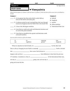
In this map worksheet, learners review latitude, longitude, equator, and prime meridian. This worksheet has 5 matching and 8 fill in the blank questions.
Mathed Up!
Enlargements
Make enlargements with and without centers. Pupils work through seven problems dealing with dilations or enlargements. The first couple items are strict enlargements without centers, while the others have centers. Class members also...
Illustrative Mathematics
Why Does SSS Work?
While it may seem incredibly obvious to the geometry student that congruent sides make congruent triangles, the proving of this by definition actually takes a bit of work. This exercise steps the class through this kind of proof by...
Mathed Up!
Translations
Introduce translations as transformations that move figures in horizontal and vertical distances with a video that shows how to translate the figures. A second video covers how to determine the translation that has occurred. Pupils...
EngageNY
Ordered Pairs
Scholars learn to plot points on the coordinate plane. The instructional activity introduces the idea that the first coordinate of a coordinate pair represents the horizontal distance and the second coordinate represents the vertical...
Curated OER
A Phylogenetic Perspective for the Cladistically Challenged
Students use M&Ms to simulate radioactive decay of elements.
