Curated OER
United States Capitals Map Quiz
In this online interactive states and captials quiz instructional activity, students examine the 50 pictured states and try to name all of the state capitals.
Curated OER
United States Identifier
Fifth graders examine and research a major region of the Unites States in groups of four. In addition, they locate the states, capitals, mammals and two bodies of water or mountain ranges found within their region. After the research,...
Arcademics
Capital Penguin
Hop across the country like a penguin from ice floe to ice floe using an interactive video game. Acting as a penguin, learners match capitals to their states. Game features allow teachers to set up competitions and check learning progress.
Little 10 Robot
Geography Drive USA™
A trivia-style virtual road trip in which the player's car is moved from state to state as questions are correctly answered. Ideally, a player would learn about different states by reading the simple brochures available in the...
Curated OER
Capitals, Oceans, And Border States
Students investigate geography by completing games with classmates. In this United States of America instructional activity, students examine a map of North America and identify the borders of Mexico and Canada as well as the Pacific and...
Curated OER
Our 50 States
Students identify the location of the 50 states using an interactive map. They practice geography skills by playing a fun game. Pupils become familiar with the state abbreviations for the US states. Students become familiar with the...
Curated OER
States/Capitals L-N: Matching
In this geography practice activity, students match the 17 listed states to the appropriate 17 listed capital cities located in the United States.
Curated OER
Projects For USA Units
Students study different regions of the United states through interdisciplinary activities. This lesson presents very creative, artistic ways for students to explore the variety of regions found in the United States.
Curated OER
Capital Cities Word Search 1
In this United States capital cities word search worksheet, students search the puzzle for 12 capital cities within the United States.
Curated OER
Capital Cities Word Search 2
For this United States capital cities word search worksheet, students identify the names of various capital cities in the United States within the word puzzle.
Curated OER
Capital Cities Word Search 3
In this United States capital cities word search worksheet, students identify the names of various capital cities in the United States within the word puzzle and test their spelling abilities.
Curated OER
Capital Cities Word Search 4
In this United States capital cities word search worksheet, students identify the names of various capital cities in the United States within the word puzzle and test their spelling abilities.
Curated OER
United States Map- State Capitals
Students explore the state capitals. In this geography lesson plan, students use a political map to identify the state capitals and place post-it notes on various capitals.
Curated OER
States and Capitals of the United States
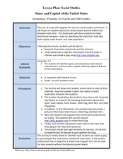
Students label states and capitals on a United States map and complete research on one of the states. In this states lesson plan, students fill in the states on blank maps.
Curated OER
Washington, D.C.: Capital of the United States
In this Washington, D.C. worksheet, students fill in a crossword puzzle as they figure out the answers to thirteen facts about the capital of the United States.
Curated OER
State Capitals- Online Interactive
In this state capitals worksheet, students learn to match the capital cities to the 50 states. Next to each name of the state, students fill in the capital city from a list that is provided. This is an online interactive worksheet.
Curated OER
The United States and Canada Review Worksheet and Study Guide
In this geography skills worksheet, students respond to 34 short answer questions about the geographic features and climates found in the United States and Canada.
Curated OER
United States Map: Capitals
In this United States outline map instructional activity, students make note of the political divisions of 50 states of the nation. This map is labeled with the 50 state capitals.
Curated OER
Mapping the United States
In this map of the United States activity, students label mountains, surrounding countries, oceans, and more. Students complete 12 tasks.
Curated OER
American States and Their Capitals
In this United States capitals worksheet, learners match the 15 states on the left side of the sheet to their respective capitals on the right side of the sheet.
Curated OER
State Capitals Fun
Third graders study the capitals of each state. In this social studies lesson plan, 3rd graders use a map of the United States to identify and locate each state's capital city. Students discuss map symbols used to identify capital cities.
Curated OER
United States Map
In this United States political map worksheet, students examine national and state boundaries. The map also highlights the location of each of the state capitals and the national capital.
Curated OER
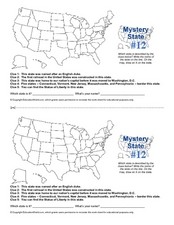
Mystery State #12
What's better than learning about US geography? Having fun while your doing it! After reviewing each of the five given clues, learners attempt to name the mystery state. A great way to reinforce geography skills and deductive reasoning...
Curated OER
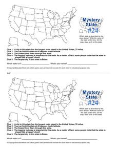
Mystery State # 24
Prepare those brains for a rousing day of learning with a fun geography activity. Your pupils use five different clues to determine the name of mystery state number 24. Where do all those potatoes come from? Idaho!


