Curated OER
Lesson 4: Fire, Rock, and Water
You can demonstrate the destructive force of volcanic mudflows to your early earth scientists using this lesson plan. Messy, but memorable, the two demonstrations require some preparation. Use one or both! Included is a link to activity...
Curated OER
Landforms Mobile
Students work together in groups to research the various types of landforms found on the Earth and locate them on a map. As a class, they discuss how the landforms affect the way people live in those areas. To end the lesson plan, they...
Curated OER
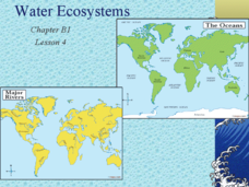
Water Ecosystems
Freshwater and Saltwater ecosystems are the focus of this Earth Science PowerPoint. Presentation is full of interesting facts, photographs, and maps. A slide with review questions appears at the end of the presentation. Very nice!
Curated OER
Volcanic Environments
A diagram showing a cross-section of Earth points out the location of different plate boundaries and displays the numbers one through five. Beneath the diagram are five photos of different types of volcanoes. The object of the activity...
NOAA
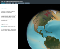
Ocean Acidification
Carbon dioxide is on the rise; does that also mean a rise in danger to humans and animals? Scholars learn what that means for the environment and more specifically the ocean. They examine data on the pH of different ocean areas and learn...
Curated OER
Ring of Fire
Students locate some of the 1,500 active volcanoes on a world map. Then by comparing their maps with a map of the world's tectonic plates, they discover that volcanoes occur because of the dynamic nature of the Earth's lithosphere.
Curated OER
Where is Everybody?
Students collect data from different grade levels at their school and develop thematic maps which show population density, and determine how this might affect the school and themselves in the future.
Curated OER
Around the World At 30o North Latitude
Reinforce the use of an atlas and reference materials with writers. They discover how geographic location can make living easier or harder. They draw an assigned journey on a map, categorize survival needs, and prioritize options during...
Curated OER
Plotting A Hurricane Using latitude and Longitude
Students explore map and plotting skills by tracing the movement s of hurricanes through the Earth's systems. a hurricane map is developed from daily media reports.
Curated OER
Rain Forests: A Disappearing Act?
Students examine and locate rainforests on maps, and research the patterns of their destruction. They develop a bar graph of rainfall and temperature data, write a journal entry, and research the people, animals, and plants/products of...
Curated OER
Time Zones
Students study the reason why time zones exist and how they are established. They predict time zones for different places on Earth.
Curated OER
March of the Polar Bears: Global Change, Sea Ice, and Wildlife Migration
Students study global change and how these changes impact wildlife. In this polar bears lesson plan students analyze maps and data to understand climate change.
Curated OER
American Journeys: Right Place, Right Time
Sixth graders measure distances on a map using string and a ruler. They complete mathematical word problems about measurement.
Curated OER
Blast It! (Learning About Copper)
Opening with background information on copper use and mining, this worksheet assesses junior geologists' reading comprehension. A map activity is available, but the map is not. There is a useful set of vocabulary matching cards and a...
Curated OER
Splish Splash
Students study drinking water. In this environment lesson, students draw the path of drinking water from the place of precipitation to the tap after researching a map and information from the United States Geological Survey water...
Curated OER
Weather
In this earth science worksheet, students use the clues given at the bottom of the sheet to solve the crossword puzzle related to weather. They identify various cloud types and how they are formed. Students also identify atmospheric...
Curated OER
Symbols and Legends
Young scholars use a legend and symbols to identify features on a map.
Curated OER
Charting Neptune's Realm: Profiles
Students identify and describe the importance of nautical profiles in early navigation. They draw a profile of a street or mall and explore the effectiveness of different types of directions.
Curated OER
Wow! You're Eating Geography
Learners examine patterns of food producing areas, and identify foods that are grown locally, in the U.S., and around the world. They map and graph the major food crops of their local area, the U.S., and other countries, and discuss the...
Curated OER
The Geography - Writing Connection
Students examine and describe the four physical systems of the Earth. Using two of the systems, they practice their writing skills and use vocabulary associated with the different types of landforms. They predict the types of shelters...
Curated OER
Proportions and Scale Factor for Measurement
Learners explore the concept of proportion. In this proportion lesson, students use google maps to find the distance the their school is from home. Learners discuss what a scale factor is through teacher led discussion. Students...
Curated OER
What Is El Niño?
Students access information at remote sites using telecommunications, identify impacts by reviewing past El Ni??o events, make and use scale drawings, maps, and maps symbols to find locations and describe relationships.
Curated OER
Various Industries to Help Hawaii's Economy
Students identify various industries in Hawaii and where those products/services are exported to. They create a timeline which highlights important dates and events of those different industries. Finally, they identify on a map places...
Curated OER
Garb and Grub Across the Globe
First graders discuss what part of the world their ancestors came from. They locate the locations on a map and discuss the differences and similarities of each continent and their people. They become familiar with the traditional...
Other popular searches
- Earth Scene Concept Maps
- Earth Scone Concept Maps
- Earth Science Mapping
- Earth Sciecne Concept Maps
- Mapping Earths Surface
- Mapping Earthquakes


