Curated OER
Mapmaker, Mapmaker, Make Me a Map
Second and third graders practice with basic map skills. They create their own map including a legend and a compass rose. This fabulous plan has many excellent websites linked which allow learners to explore maps of all kinds; including...
Mr. Printables
Map of The USA Jigsaw Puzzle
Encourage young learners to explore the United States with this printable map puzzle. A fun activity that engages children in learning US geography.
Curated OER
West Virginia Map
In this map activities worksheet, students use an outline of the map of West Virginia to add the state capital, major cities, and other state attractions. Students complete 3 activities.
Curated OER
Creating a Thematic Map
Students create and analyze a weather-related data table and a thematic map based upon information provided.
Curated OER
Mapping West Virginia
Fourth graders explore West Virginia. In this Unites States geography lesson, 4th graders discuss the type of land and the cities in West Virginia. Students create two overlays, with transparencies, that show the natural land and the...
West Virginia Department of Education
A State of Convenience: The Creation of West Virginia
Ever wondered why there is a West Virginia but not an East Virginia? The resource answers questions like this one and more as it takes an in-depth and detailed look at the history of West Virginia and how it became a state. Several...
Curated OER
Regions of Virginia
For this geography worksheet, 5th graders identify the regions of the state of Virginia and sort them according to location. Then 10 questions focus upon the specifics of different regions.
Curated OER
Mapping Mistakes
Students examine early European maps and explore geographic errors. They also view maps of the geography of North America. Students discuss the obstacles faced by early explorers in mapping unexplored territory. They consider what the...
Curated OER
West Virginia Outline Map
In this West Virginia outline map worksheet, learners examine political boundaries of the state and the placement its capital city as well as its major cities. This map is not labeled.
Curated OER
Story Map Book Report
This is an example of what a story map book report can look like using mind wing teaching concepts. Consider this idea as a way to provide special needs or those with learning disabilities a way to communicate what they know or learned...
Curated OER
A "Sweet" Lesson in Economics
Students discover how to determine the flavor of a jellybean using different key documents. In this economics lesson, students discuss Virginia economics and begin an activity in which they will help decide on the what jellybean flavors...
Curated OER
Virginia's Five Geographic Regions
Tenth graders study the products and industries of five major geographic regions in Virginia. They use web based resources to examine maps of Virginia and to make a large classroom map which they label with the products and industries....
Curated OER
Mapping the New World Lesson Plan
Learners compare two maps of the same area from different time periods. In this American History lesson, students look at two maps of the English colonies from 1636 and 1651. They discuss why the maps changed and predict maps from the...
Curated OER
How Big is the Playground: Creating a Map
Students create a topographical map of an area outside of the school. For this mapping lesson, students compile data on angles, distances, and key landmarks for a predetermined area on the school grounds to create a map using Geometer's...
Raymond C. Jones
Story Mapping History Frame
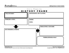
Map out the conflicts throughout history with a graphic organizer. It includes a section for kids to list the participants in an event, the problems or goals, and the theme or lesson learned.
Curated OER
Virginia cities
In this Virginia cities worksheet, students fill in the map with the cities in Virginia next to the dots on the map. Students fill in 8 cities including the capital.
Curated OER
United States Map Lesson
Students explore basic map skills. In this United States geography lesson plan, students define "country" and "state," locate their state on a United States map, and identify and trace state boundaries defining their state and...
Curated OER
United States Map- State Capitals
Students explore map skills. For this state capital lesson, students view a United States Political Map and identify and use post-it notes to label the state capitals.
Curated OER
Concern in East Virginia
Students investigate the statehood of West Virginia. In this lesson on statehood, students use primary sources to examine the separation of Virginia from Wes Virginia. The lesson incorporates a field trip as a means to put knowledge into...
Curated OER
Virginia: The Land and its First Inhabitants
Students review the five geographical regions of the state of Virginia. Using a map, they locate and label Virginia, surrounding states and the crops grown in the area. They present their map to the class and complete a worksheet to end...
Curated OER
Virginia Geographic Regions
Third graders observe the five geographic regions of Virginia which have distinctive characteristics based on their landforms and bodies of water. They then describe the types of landforms and bodies of water in the region where they live.
Curated OER
Virginia State Map
In this geography of Virginia worksheet, students color the map and label major cities and physical features. Students also study a second map showing the location of the state of Virginia in the United States.
Curated OER
John Smith Map Lesson Plan
Fourth graders answer questions about John Smith, and also they figure out what was necessary are needed for surviival. Students are given a replica of Smith's 1612 map, they then answer questions using the map as their resource. ...
Curated OER
Salt Relief Map of Virginia
Fourth graders create a salt relief map of the four regions of Virginia. They indentify land forms and bodies of water, and summarize how they made their project.
Other popular searches
- Landform Map of Virginia
- Agriculture Map of Virginia
- Map of Virginia Resources
- Topography Map of Virginia
- West Virginia Map
- 18th Century Virginia Map
- Land Form Map of Virginia
- Virginia Cultural Map
- Virginia Map
- Virginia Map Activity
- Cultural Map of Virginia
- Virginia Map Skills


