Curated OER
Early Explorers
Fifth graders study early explorers. In this World history lesson, 5th graders draw an outline of a map labeling each part, build geographical features out of dough, and paint each of the land and water features.
Curated OER
Geography Booklet
Sixth graders explore geography terms. Students use resources to find real examples of landforms in the world. They create a map showing the landform. students label the surrounding features, countries and states. Students use each...
Curated OER
Contour Map Worksheet #4
There are only four questions here. There is a contour map of Cottonwood, Colorado and the creek that crosses it. Earth scientists tell in what direction the creek flows, identify the highest elevation on the map, draw a topographic...
Curated OER
Let's Make a Map
Second graders draw maps of their playground, noting objects such as trees and play equipment. Working in groups, they make maps of different parts of the school and assemble them into a schoolwide map. They make maps on a field trip to...
Curated OER
Map of Asia
In this map worksheet, 3rd graders will study a map of Asia. Students will use this map to label and/or familiarize themselves with various aspects of the continent.
Curated OER
Map of Antarctica
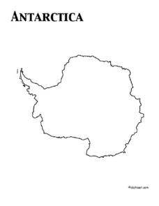
In this map worksheet, 3rd graders will study a map of Antarctica. Students will use this map to label and/or familiarize themselves with various aspects of the continent.
Curated OER
Electric Field Mapping / Equipotential Lines
Students determine the equipotential lines surrounding a charged object. In this physics lesson, students draw lines to identify areas. They relate the spacing of the field lines to the strength of the charge.
Agriculture’s Lasting Heritage
Apples Around Us
Apple tasting launches an investigation of the story and travels of John Chapman, also known as Johnny Appleseed. After listening to his story, class members craft a summary of the tale, chart his journeys on a map, and sample different...
Curated OER
The Rocks Under Illinois
The goal of this fine geology lesson is to have learners create a map that shows how the rock layers are arranged far underground where they can't be seen. The ambitious lesson plan requires high schoolers to learn the law of...
Curated OER
Giving Students a Little Latitude
Students use a world outline map to locate places using coordinates of latitude and longitude. They answer questions about places based on their knowledge of the map and on their research and make up more questions of this sort for each...
Curated OER
European Cities
Learners study European cities and label countries on a map, match cities to countries, and answer true and false questions. In this European cities lesson plan, students also guess the names of cities they see pictures of.
California Polytechnic State University
Australian Geography Unit
At the heart of this resource is a beautifully detailed PowerPoint presentation (provided in PDF form) on the overall physical geography of Australia, basic facts about the country, Aboriginal history, and Australia culture and lifestyle.
Curated OER
Antarctica
In this map activity, 3rd graders explore a map of the continent of Antarctica. Students will color and label the map of the continent.
Curated OER
Poland
For this Poland maps worksheet, 6th graders research, study and label the regions, states and landmarks on a map of Poland. Students hang their maps up on the wall.
Curated OER
Germany
In this map of Germany worksheet, students view a map of Germany and then label its regions, major cities and important landmarks on a paper version of a map of Germany.
Curated OER
France
In this map of France worksheet, students view and label a map of France with its regions, major cities and important landmarks. Students include a compass and legend to accompany their map.
Curated OER
India
In this map of India learning exercise, students label a map of India with its regions, major cities, important landmarks and include a rose compass and legend.
Curated OER
Ireland
In this map of Ireland worksheet, students label an Ireland map with its regions, major cities, important landmarks, compass rose and a legend.
Curated OER
Switzerland
For this map of Switzerland worksheet, learners view and label on a map of Switzerland its regions, major cities, important landmarks, compass rose and a legend.
Curated OER
Thailand
In this map of Thailand activity, students view and label a map of Thailand with its regions, major cities, important landmarks, compass rose and a legend.
Curated OER
Vietnam
In this map of Vietnam worksheet, students view and label on a map of Vietnam its regions, major cities, landmarks, compass rose and a legend.
Happy Housewife
State Notebooking Pages
When learning about US geography, it can hard to remember facts about 50 different states. Help your young scholars organize all of this information with a collection of easy-to-use note-taking guides.
Ed Helper Clip Art
Main Idea Mountain
After reading a text, learners fill out a graphic organizer in the shape of a mountain, with the main idea as the peak.
Curated OER
Saudi Arabia -- Future city
Seventh graders summarize an article on Masdar. In this summarizing lesson students clearly explain three of the four points provided in an outline of the article. The students write an essay and identify six physical features of the...
Other popular searches
- Labeling a Map
- Africa Map Labeling
- Midwest Map Labeling
- Geography Map Labeling
- Labeling a Map Continents
- Labeling Map Parts
- Labeling Parts of Map


