KOG Ranger Program
Fire Behavior in Forests
Understanding the ways a fire will act is a key factor in fire safety and fire prevention. Young campers focus on how the weather and terrain can affect the behavior of a fire with topographic maps and different scenarios.
Curated OER
Mapping Your Schoolyard Habitat
Students explore the terrain, structures, plants and signs of habitats around their schoolyard. They draw a sketch map showing the different areas around the schoolyard. Students identify the location of weeds and native plants on their...
Global Oneness Project
The Value of Ancient Traditions
Imagine having to give up cell phones, computers, and TV? What would be lost? What gained? An examination of the Drokpa, a nomadic people who live in the grasslands of Tibet, provides class members an opportunity to consider how access...
Curated OER
Making Maps
For this map making worksheet, students learn about the science of making maps, which is cartography. They then answer the 11 questions on the worksheet. The answers are on the last page.
Conneticut Department of Education
Instructional Strategies That Facilitate Learning Across Content Areas
Imagine 28 instructional strategies, appropriate for all subject areas and all grade levels. Directed Reading-Thinking Activities (DRTA), Question-Answer Relationship (QAR) activities, KWL charts, comparison matrixes, classification...
NOAA
Into the Deep
Take young scientists into the depths of the world's ocean with the second lesson of this three-part earth science series. After first drawing pictures representing how they imagine the bottom of the ocean to appear, students investigate...
Curated OER
Idea Mapping
Students generate, share and display ideas as a group. They break into small groups to work on hand-drawn maps made up of concentric circles. they come before the group and make a similar diagram by charting each other's characteristics.
Curated OER
Mapping Your Watershed
Students examine student created maps to locate geographical features such as hills, cliffs, flat meadows, stream beds, etc. They use watershed topo maps to identify landmarks, water flow, and elevation of several features. In addition,...
It's About Time
Where are the Volcanoes?
Middle school geologists map the volcanoes closest to themselves, learn about map distortion, and infer possible future volcano locations. A focus on latitude, longitude, and volcanoes beneath the ocean helps connect the lesson.
Curated OER
A Different Kind of Rock Star: Part 2
Learners examine our society's fascination with Mars. In this journalism instructional activity students read an article that outlines the various ways Mars has captured our imagination and are given topics for discussion and a chart to...
Curated OER
Design an Island
Young scholars make a map of an imaginary island using the topographic symbols provided from a worksheet. Students place lakes, dwellins, reefs, etc. in areas where they would logically be located from understanding how the topography...
Curated OER
Weather Forecasting Unit
Students study weather concepts, mapping, characteristics in this series of lessons.
Curated OER
Design an Island
Students explore islands. They create a two- or three-dimensional map of an island. They explain how the topography of an area influences the location of water sources, ecosystems, and human settlements. Lesson includes adaptations for...
Curated OER
Having a Hot Time on Mars!
In this cosmic radiation on Mars worksheet, students study a radiation map of Mars taken by the MARIE instrument on the Odyssey spacecraft. Students answer 4 questions using the radiation map and they answer questions about the exposure...
Howard Hughes Medical Institute
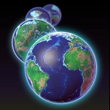
EarthViewer
Can you imagine Washington DC and London as close neighbors occupying the same continent? Learners will be fascinated as they step back in time and discover the evolution of the earth's continents and oceans from 4.5 billion years ago to...
Curated OER
Settlement Exploration: Then and Now
NASA has crafted an imaginative and memorable series of lessons, "NASA and Jamestown Education Module." This lesson is one of the five components. In it, middle schoolers connect history and science by comparing the settlement of...
Curated OER
Tracking the Salt Front
Using the Hudson River as the focus, learners discuss the difference between salt water and fresh water environments, analyze maps and graphs, and complete addition and subtraction problems. This lesson comes with a wealth of...
Orange County Water Atlas
Location, Location, Location…
Young geographers discover not only how to read and recognize coordinates on a map, but also gain a deeper understanding of latitude and longitude and how climate changes can vary significantly across latitudes.
Curated OER
Water Cycling in the Wilderness: Alaska quarter reverse
The Alaskan wilderness contains every imaginable element of the water cycle: it has flowing streams, cool spring rain, and frozen glaciers. Pupils use a series of worksheets to identify and define evaporation, condensation, and...
Jefferson Lab
Optics: Mirrors and Lenses
Did you see that or did I imagine it? Optical illusions are often created with mirrors and lenses, and here is a presentation that covers many different types of mirrors and lenses and how they work. Flat, concave, and convex mirrors, as...
Curated OER
Watershed
Students study watersheds and use topo maps to help explore where they are located. In this watershed activity students delineate their watershed on their own.
Curated OER
Globe Skills Lesson 10 Apollo 11
Young scholars develop their globe skills. In this geography skills lesson, students use a globe and a softball to replicate distance between the earth and its moon.
Curated OER
Oceanic Heat Budget Activities
Students map and research imaginary islands located in different parts of the world. They describe the weather and climate of their island and show how local currents, water temperatures and waves may influence the weather patterns.
Curated OER
Rainfall Measurement
Students are introduced to rainfall measurement and develop a network of rain gauges. Students measure rainfall, plot rainfall maps and calculate total rainfall volumes during rainstorms.


