Curated OER
Tobacco: Promotion Tactics and the Law
Youths aged 13 & 14 are most likely to notice and remember in-store tobacco promotions. Class members dissect tobacco advertising tactics and learn about relevant legislation by participating in guided discussion. Assessing...
Fremont Unified School District
4th Grade California Relief Map Project
Bring life to your next California geography lesson with this great project! Learners design a three-dimensional wall relief map of California, painting and decorating regions using a variety of materials and labeling major geographical...
It's About Time
Organic Substances
Host an exciting lab in which learners burn fruit rinds to better understand hydrocarbons. A reading passage and analysis questions wrap up the lesson.
Curated OER
Trekking to Timbuktu: The Geography of Mali -Teacher Version
Students investigate the geography of Mali. They locate Mali on a satellite map, explore various websites, describe the landscape and climate, label a map, and write an essay about the Niger Riger.
Curated OER
The Country of South Africa-Map Activity
In this South Africa map worksheet, learners label given features and places on a blank map. A reference web site is given for additional activities.
Curated OER
Mapping Germany
In this Germany worksheet, students label the map of Germany with different landmarks. Students label the map with 10 different cities, rivers, and borders.
Curated OER
The Middle East
Pupils investigate the countries of the Middle East. In small groups, they conduct Internet research, conduct a debate, draw and label a map, and present their information to the class in the form of a presentation.
Curated OER
Mapping China
Students identify cities in China on a map. In this map skills instructional activity, students locate the continent of Asia and the country of China. Students use a blank map to label China and bordering countries.
Curated OER
Mapping Japan
For this Japan worksheet, students label cities, islands, seas, and more. Students label 11 different areas of the country of Japan.
Curated OER
The United Kingdom
In this United Kingdom activity, students label the capitals and color the countries of the United Kingdom. Students complete 8 tasks.
Curated OER
Monsoon Asia
In this Asia map worksheet, students label the countries on the provided blank outline map of Asia. The countries labelled should be countries that experience monsoons.
Curated OER
Living in the UK
Students research the countries in the United Kingdom. In this geography lesson, students visit suggested websites and complete the included worksheets. Students work in pairs to complete the questions. This is a WebQuest lesson.
Curated OER
Prepositions of Place
In this prepositions worksheet, students read picture labels with prepositions of place, and then write labels under pictures. Students complete 2 activities.
Curated OER
China: How to Put Some "Tang" in Your Medieval Dynasties
Fourth graders label the countries that border China and the physical features of Asia. They discuss the physical features of Asia and label them on the other map.
Curated OER
Sea and Learn: A Fleet of Nations
Students observe a timeline and listen to reasons for the Battle of Trafalgar. They look at a list of nationalities in the British fleet and use a map and an atlas to locate the birthplace of the sailors in Nelson's fleet. They then...
Curated OER
North Africa & Southwest Asia Map Quiz
In this geography skills instructional activity, students examine the blank outline map of North Africa and Southwest Asia. Students label the countries located in the region.
Curated OER
Understanding Ethnic Labels and Puerto Rican Identity
Middle schoolers brainstorm a list of stereotypes associated with the Hispanic or Latin culture. In groups, they use the internet to research issues of importance to the Puerto Rican community. They focus on the cultures that speak...
Curated OER
Interdependence in a Global Community
Students locate the geographic origin of a variety of products used in our society. They find countries in an atlas or on a wall map. They define the term imports and emphasize the theme of MOVEMENT and use it to explain interdependence.
Curated OER
Iraq, Where's That?
Students identify the Middle Eastern countries on the map and the oil-producing countries of OPEC in the region. They examine whether the presence of important producing oil fields qualifies as a characteristic of this region.
Curated OER
Helping Countries in Turmoil
Students create an advertisement that promotes a nonprofit. In this service learning lesson, students research emerging democracies and brainstorm ways to help local nonprofit organizations.
Curated OER
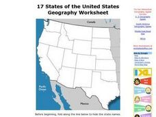
17 states
In this states worksheet, students label states in the United States that are on the west side of the country. Students label 17 states.
Curated OER
South America Map
In this South America worksheet, students view a blank map of South America that they can color or label. Students do this for all the countries in South America.
Curated OER
Map of Finland
In this map of Finland worksheet, students label the cities in Finland. Students can also color this map, cut it out, or put it together with other countries.
Curated OER
Map of Africa
For this Africa worksheet, students analyze a labeled map of Africa. The map shows all the countries and regions as well as the bodies of water. There are no questions to answer.


