Hi, what do you want to do?
Curated OER
Glaciers Worksheet #1
The landscape impacted by glacier activity is drawn at the top of this worksheet. Ten multiple choice questions follow, some relating to the diagram, and some about the quality of soil left by glaciation. It is not often that you come...
Curated OER
Volcanoes: Fifth Grade Lesson Plans and Activities
Fifth graders explore volcanoes and the rocks they produce using the Internet. The lab portion of the lesson prompts young scientists to compare and describe igneous rocks. Next, they critique a pair or more of...
Curated OER
Earthquakes: Fifth Grade Lesson Plans and Activities
After learning about P waves and S waves, fifth graders view the intensity of earthquakes by examining seismographs and images of earthquake damage. Young scientists then forecasting future quakes by analyzing data about...
Curated OER
Mid-Ocean Magnetism
Students investigate magnetic evidence that supports the theory of sea floor spreading.
Curated OER
Hazards: Fifth Grade Lesson Plans and Activities
After comparing earthquake and volcanic hazards to one another, fifth graders take a closer look at damage associated with a volcanic eruption. They then create a simulation of mudslides due to a volcanic eruption. Using different...
Curated OER
Earthquakes
Sixth graders explore reasons for earthquakes. They discuss and describe the types of faults. Using the internet, 6th graders research a specific location of a former earthquake. They describe the damage, magnitude, the epicenter,...
Curated OER
Faulty Movement
Students discover the faults throughout the Earth. They describe the different types of faults and how they are related to earthquakes. They build models of the faults.
Curated OER
Plotting Earthquakes
Students, after plotting earthquake locations on the map, should correctly; identify the pattern of earthquake locations and identify the ring of fire.
Curated OER
The Science Behind Tsunamis
Natural disasters can be teachable moments that create more scientifically literate citizens.
Curated OER
Sea Connections: Marine Ecosystems
Students identify producers and consumers from marine ecosystems and describe the balance among them in the environments. After constructing a food chain from a marine ecosystem, they examine human activities that can upset the balance...
Curated OER
Find the Epicenter
Eighth graders visit the Virtual Earthquake Web site and complete activities that demonstrate how geologists locate the epicenters of earthquakes. The site uses actual data from historic earthquakes.
Curated OER
Whole Lotta Shaking Going On
Students explore earthquake activity in California. They observe the historical data and create databases and graphs of the earthquakes. Students analyze the data and form a hypothesis about future earthquakes.
Curated OER
Earthquake
Students view a video and conduct a problem solving activity to explain the effect different waves have on the earth's structure and what effect they have on different structures.
Curated OER
American Journeys: Right Place, Right Time
Sixth graders measure distances on a map using string and a ruler. They complete mathematical word problems about measurement.
Curated OER
Creating Craters
Students explore parts of an impact crater and compare and contrast craters found in Earth, the Moon, and Mars. Crater formation is modelled and the relationship of mass, velocity, and size of the projectile to the crater formation is...
Curated OER
A Whole Lotta Shakin'
Students read first hand accounts of earthquake survivors in order to begin the describe the different types of earthquake waves and the order in which they arrive. They engage in using earthquake waves as a means to indirectly study the...
Curated OER
Earthquakes
Students observe the melting of ice. For this phase change lesson, students observe ice as it melts. They discuss the process and create a Venn diagram comparing water and ice.
Curated OER
Bhutan, the Last Shangri-La: Sandwich Squash: How the Himalayas Were Formed
Students create and record a model of mountain formation. They identify major mountain building formations. Students understand how the Himalaya Mountains were formed, why they are located near Bhutan, and why they are becoming larger.
Curated OER
Earth System Science
Students explore the Earth and its ability to support life. They discuss the geosphere and the water cycle and complete the Water Wonders activity. After completing the activity, they respond in their journals and reflect upon the...
University of Oregon
The Electronic Universe Project: Plate Boundaries/plate Tectonics
Visit this site to learn more about the different types of plate boundaries. Includes color pictures and easy-to-understand examples of how and why plates move the way they do.
Other
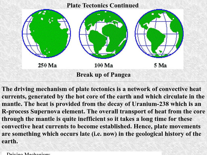
University of Delaware: Plate Tectonics
This site is a very simple overview of plate tectonics. It includes a map of all the major plates and a diagram of the layers of the earth.
Science Education Resource Center at Carleton College
Serc: Heat on the Move
This activity is meant to be one of many common experiences that help students understand that convection is a major driving force on our planet.
Other popular searches
- 7 Crustal Plates
- Movement of Crustal Plates
- Seven Crustal Plates
- Crustal Plates Map
- All Crustal Plates
- Crustal Plates Lab
- The 7 Crustal Plates
- 84 Crustal Plates


