Kate Stickley
Reading the World: Latitude and Longitude Lesson latitude and longitude, maps, coordinates on a map, prime meridian, reading maps, equator, globes
Find five activities all about longitude and latitude! Use oranges to show the equator and prime meridian, plot birthdays on a map using coordinates, and plan a dream vacation.
Teach Engineering
What's Wrong with the Coordinates at the North Pole?
Here is an activity that merges technology with life skills as individuals use Google Earth to explore the differences between coordinate systems and map projections. The self-guided activity is the fourth segment in a nine-part unit....
Orlando Shakes
The Great Gatsby: Study Guide
Uncover the exciting world of the Roaring Twenties with The Great Gatsby study guide. Individuals become critics as they write a review of the production. Scholars also read historical information and analyze the differences between the...
Curated OER
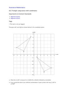
Triangle Congruence with Coordinate
Two triangles are displayed on a coordinate plane. Youngsters apply a reflection and a translation to demonstrate their congruence. This exercise makes a terrific tool for teaching these concepts, or a way to assess learning.
Curated OER
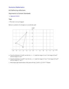
Reflecting Reflections
A triangle rests in quadrant two, from which your class members must draw reflections, both over x=2 and x=-2. This focused exercise strengthens students' skills when it comes to reflection on the coordinate plane.
Teach Engineering
Searching for Bigfoot and Others Like Him
Individuals create a GIS data layer in Google Earth that displays information about where one might find seven different cryptids. The class members research to find data on cryptid sightings they can include in their data...
Teaching Tolerance
Fairness Fair
How can we create a more fair world? Chances are, class members have some ideas! After reading a text about fairness, individuals create skits around the ideas of fairness. Extend the learning and make their presentations a...
Teaching Tolerance
Identity Artifacts Museum
Who are you? It's a simple question, but younger learners have the opportunity to express their complex identities by making artifacts that represent parts of their identities. After engaging in the activity, they share who they are with...
Social Studies for Kids
Social Studies for Kids: Latitude and Longitude
A collection of latitude and longitude mapping activities ranging from pin-pointing exact locations on the globe to researching the history behind this basic geography concept.
National Geographic
National Geographic: Introduction to Latitude and Longitude
In this lesson, students learn to determine the latitude and longitude of locations within the United States, while making observations about climate and the ways in which these measurements can be useful. Includes maps and discussion...


