Mathematics Assessment Project
Sorting Equations of Circles 2
How much can you tell about a circle from its equation? This detailed lesson plan focuses on connecting equations and graphs of circles. Learners use equations to identify x- and y-intercepts, centers, and radii of circles. They also...
Curated OER
The Big Circle
Students explore geography by participating in a mapping activity. In this concentric ring lesson plan, students utilize a poster board, string and markers to identify their current location within the entire world. Students write about...
CK-12 Foundation
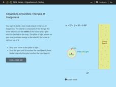
Equations of Circles: The Sea of Happiness
Map this! Help your young mathematicians draw a circular island on a map. Given specifics of the location and size of an island on a map, pupils transform a circle to meet the given requirements. They then determine the location of the...
Curated OER
Why All Maps Lie
Eighth graders discover the fundamental advantages/disadvantages of both maps and globes. They see that maps may distort size, shape, distance and direction. They discuss the advantages and applications of 5 types of map projections and...
Curated OER
United States Map- Map Legend/City Symbols
Young scholars investigate the United States map. In this map skills geography lesson, students explore city symbols on the map legend and identify them. Young scholars use post-it notes to mark various symbols.
Curated OER
From Maps to Models
Students explore watersheds through the use of a topographic map. They observe topographical maps and discuss their characteristics. In groups, students create a model clay island and make a topographical map of it. Afterward, groups...
Curated OER
How To Read A Map
In this map skills worksheet, students view a map and answer five short answer questions by using the map key as a guide.
Curated OER
Mapping Out the Story
Discuss the reading comprehension strategy of summarization with your elementary schoolers! They read a chapter from their social studies textbook, Regions Near and Far, and create a map, or word web, for the chapter. They identify...
Mathematics Assessment Project
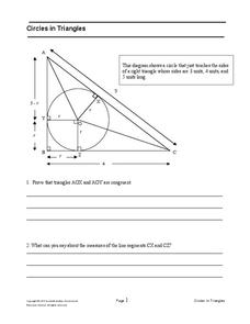
Circles in Triangles
Circles, and triangles, and tangents, oh my! In the assessment task, learners first answer questions leading to the radius of an inscribed circle for a given right triangle. They then use the result to independently determine the radius...
Curated OER
Geography Terms
Introduce the terms and concepts related to basic map and geography skills. Terms include full definitions and cover latitude, longitude, the Equator, Tropic of Cancer, Tropic of Capricorn, Prime Meridian, and the International Date Line.
Curated OER
Plotting Earthquakes
Young scholars plot earthquakes on a map. In this lesson on earthquakes, students will explore recent earthquake activity in California and Nevada. Young scholars will plot fault lines and earthquake occurrences on a map.
Curated OER
Countries Involved in World War II
Learners create their own floor map of Europe, Northern Africa, and the Pacific. They locate, identify, and speak for one of the countries involved. In addition, they classify the country they represent as an Axis Power or as an Allied...
Curated OER
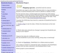
Bluebirds Project: Mapping Species
In this bluebirds project: mapping species activity, students create a map based on data for bluebirds in their area, then answer 5 questions about the mapping of the species. This page has numerous links to helpful web resources.
Curated OER
Introduction to the United States Map
Students identify a map of the United States. In this United States map lesson plan, students study a map of the United States and find various locations on the map. Students then locate and list the state that touches their state.
Curated OER
Simple Route Map
Students identify the best route between various locations on a map. In this map skills lesson, students use a landscape picture map to find routes to and from certain places. Students use map markers to highlight the routes.
Curated OER
United States Map - Lesson 11
Students explore lakes of the United States. In this geography lesson plan, students identify noteworthy lakes on a map of the United States.
Curated OER
Mapping Your Schoolyard Habitat
Students explore the terrain, structures, plants and signs of habitats around their schoolyard. They draw a sketch map showing the different areas around the schoolyard. Students identify the location of weeds and native plants on their...
Curated OER
United States Map
Students describe cities they are familiar with. In this United States Map lesson, students understand how cities are listed on a map. Students become aware of a map legend and the information in it.
Curated OER
United States Map- State Capitals
Students explore map skills. For this state capital lesson, students view a United States Political Map and identify and use post-it notes to label the state capitals.
Curated OER
Literature Circle Role Descriptions
In this literature circle role descriptions worksheet, students identify the role they play in the literature circle. The different roles include: summarizer, vocabulary finder, questions writer, story mapper. Each role has three to...
Curated OER
Mapping the Library
Learners compare their school library with another library such as: town library, for example, or a virtual library and identify the most important features. Students use their observations to create a map of the school library that can...
Bowland
Alien Invasion
Win the war of the worlds! Scholars solve a variety of problems related to an alien invasion. They determine where spaceships have landed on a coordinate map, devise a plan to avoid the aliens, observe the aliens, and break a code to...
Curated OER
Simple Route Map
Students demonstrate how to locate features on a Landscape Picture Map. In this map skills lesson, students locate and circle places where they would go to mail a letter, return a library book, or play a baseball game.
Curated OER
Introduction to the United States Map
Students explore the United States using a map. In this map lesson, students discover how to use a United States map and a globe to locate places.
Other popular searches
- Brainstorming Circle Maps
- Blank Circle Maps
- Circle Maps Animals
- Pet Circle Maps
- Language Arts Circle Maps
- Using Circle Maps
- Writing, Thinking Maps, Circle
- Thinking Maps, Circle


