Curated OER
Orienteering: Map Skills
Students use a map to locate six specific landmarks on a course using a map. They identify how maps can help us and write a paragraph describing how to get from one landmark to another on the map.
Curated OER
Orienteering: Map Skills
Students discover orienteering. In this orienteering lesson, students search for six specific landmarks. Students brainstorm how maps and landmarks are helpful.
World Maps Online
Introduction to the World Map
Students identify the differences between maps and globes. In this map skills instructional activity, students are shown a globe and a map and recognize the differences. Students use post-it notes to locate several locations on the world...
Curated OER
Math with Maps and Globes
Students round out their math skills with these ‘round the world' ideas. In this math and geography lesson, students try out time zone sticks, a polar race, and tic-tac-globe to engage them in learning more about globes and the...
Curated OER
Middle Ages Traveler
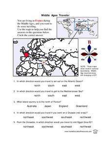
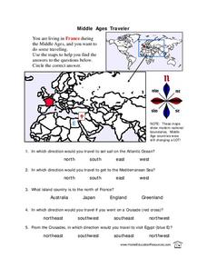
In this map worksheet, young scholars are given three maps of France to use to answer multiple choice questions. Students complete an activity from the perspective of a Middle Ages traveler.
Curated OER
Lesson Plan on Map Skills for South Asia
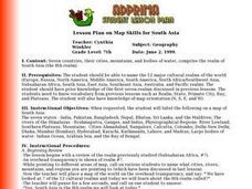
Seventh graders observe and discuss an overhead transparency map of South Asia. In small groups, they label a blank map of South Asia, and listen to a lecture on the realm.
Curated OER
Middle Ages Traveler
In these Middle Ages worksheets, students use the maps to help them find the answers to the questions that help them understand the directions of north, south, east and west. Students also color another map of France according the...
Curated OER
Cultural Mapping
Young scholars are introduced to the cultural diversity in Australia. Using new vocabulary, they define multiculturalism and explore their own cultural backgrounds. In groups, they complete a series of worksheets to develop a better...
Cornell University
Too Much of a Good Thing?
Continuing their study of beneficial insects, young entomologists discover where in the world some of these bugs are. By labeling, coloring, and using the scale on a map, pupils explore the territories and arrival of the Asian lady...
Curated OER
Old World and New World - Why Contact Took So Long
Students use a globe to determine why contact between the old world and the new world took a long time. In this map skills lesson plan, students analyze routes between regions to determine why it took so long for the old world and the...
Curated OER
Australia
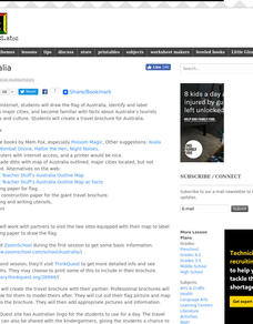
Young scholars research Australia using the Internet. They draw a flag, identify and label Australia's major cities. They discover facts about Australia's tourists attractions and culture. They design a travel brochure using the facts.
Curated OER
Australian Aboriginal Art And Storytelling
Students explore Aboriginal storytelling traditions through the spoken word and through visual culture. They listen to stories of the Dreamtime told by the Aboriginal people and investigate Aboriginal storytelling in contemporary dot...
Science 4 Inquiry
Edible Plate Tectonics
Many people think they can't observe plate tectonics, but thanks to GPS, we know that Australia moves at a rate of 2.7 inches per year, North America at 1 inches per year, and the Pacific plate at more than 3 inches per year! Scholars...
Curated OER
Australia
Sixth graders study the continent of Australia. In this Geography lesson plan, 6th graders create an Australian city using their knowledge of Australian cities. Students participate in a game about the continent.
Curated OER
Australian Aboriginal Art and Storytelling
Young explorers investigate Australian Aboriginal culture by listening to traditional Dreamtime stories and examining dot paintings created by Aboriginal artists. In addition, they locate the country on maps, discuss the geography of...
Curated OER
The Whiningdingdilly
Students read the book The Whiningdingdilly and complete a Venn Diagram, write a friendly letter, find misplaced animals, and morph animals and humans. In this The Whiningdingdilly lesson plan, students practice reading, writing, map...
Curated OER
Australian Travel Adventure
Seventh graders are introduced to the states and territories within Australia. Using the internet, they bookmark sites and take notes on what they want to share with their classmates. They also complete a map study on the country to...
Curated OER
Floods
Students explore Earth science by answering study questions on-line. In this natural disasters lesson plan, students research Australia flood statistics over the past 40 years and identify patterns. Students utilize the web to view...
Curated OER
Continents of the World
Second graders participate in a lesson about how people are the same, how people are different and where the continents are located. They go on a trip around the woworld to visit a country in each continent.
Curated OER
Expanding Children's Geographic and Economic Worlds
Students learn their addresses and gain a sense of connection between their neighborhood and the rest of the world and the universe.
Curated OER
What Makes a Tropical Rainforest Special?
Students examine the characteristics of the tropical rainforest. Using a map, they locate the rainforests found around the world, continents and the equator. Using the internet, they research the various layers of the rainforest and...
Curated OER
Shadow Trackers
Students use online websites to inquire about the cycle of day and night. In this web based lesson, students are able to see the movement of the sun and Earth. Students can look at different parts of the Earth as if they were on the Sun...
Curated OER
The Seven Continents Scavenger Hunt
Who doesn't enjoy an engaging scavenger hunt? Here, scholars listen to, and discuss, the informative text, Where is my Continent? by Robin Nelson. They then explore the seven continents and four major oceans using...


