Curated OER
State Poster Fair: US Geography, Social Science, Art
Students research a US state, design and construct a state 'poster' to display important facts about that particular state. They present their work to the class.
Curated OER
Come Visit My State!
Fourth graders conduct research on a selected state in the United States. They complete a WebQuest and conduct research on a variety of websites. Students then organize and present a visual display about their state that includes a...
Curated OER
Mexico: A Look At Its Culture and Geography
Students canvass the Mexican geography, culture, dress, language, crafts, and traditions in this unit of eight lessons. The Mexican Independance Day is compared to our own and the contributions of the Mayan, Azetec, and Spanish are...
Curated OER
State Geography
Students reinforce their knowledge of the locations of the states. They need to know where the states of the United States are located in relation to each other. Students review the states symbols, capitals and landmarks as well within...
Curated OER
Learning the 50 States
Students become familiar with all 50 states over the course of ten days.
Curated OER
Our Fifty States
Seventh graders identify and locate all fifty states in the United States and their capitals. Individually, they research one state identifying when it became a state, its motto, song, flower and nicknames. To end the lesson plan, they...
Curated OER
Geography Golf
Young scholars practice their knowledge of states and capitals while at the same time working on motor skills. This activity also promotes working together in small groups.
Curated OER
Study of States in the five U.S. Regions
Fourth graders identify the five regions and the states within them. They research a state from each of five regions, then they choose one of those states to do an extensive research report on following teacher guidelines. They work in...
Curated OER
State Research
Students apply previous knowledge of the United States to label a classroom map and then work independently to complete an online scavenger hunt. This lesson is intended for an upper-elementary classroom studying American History and/or...
Curated OER
Rhode Island State Map
In this geography of Rhode Island worksheet, students color and label a map with the major cities and physical features. Students also study a U.S. map to learn the location of the state of Rhode Island.
Curated OER
Our State Road Trip
Students take a virtual tour of the country of China instead of a state. Using the Internet, they examine the differences between a political and physical map and use latitude and longitude to locate specific places. They also research...
US Mint
Absolutely and Relatively: The Puerto Rico Quarter Reverse
How much does your class know about Puerto RIco? How much can they learn from the back of a 2009 quarter? Use the coin, part of a series of quarters that depict US territories, to teach learners about the geography, culture, and history...
Curated OER
Map Your State: Regions of Arizona
Fourth graders define vocabulary and locate physical features on maps. In this mapping activity, 4th graders explore regions of Arizona through landforms found on topographic maps. Students research the history and culture of...
Curated OER
U.S. Geography: California
For this map skills about the state of California worksheet, learners locate and label specific places and areas and create a map key and symbolize the economy and areas of personal interest. Students answer 5 questions.
Workforce Solutions
Workforce Solutions 4-5 Lessons
Four lessons focus on job opportunities in Texas. In the first lesson, scholars examine the geography of Texas in preparation for analyzing data that showcases the economy of different regions. Lesson three challenges pupils to research...
Scholastic
Owl Moon Teaching Plan
Capture the engagement of young readers with this collection of activities based on Jane Yolen's book, Owl Moon. Following a shared reading of this children's story, the class explores the geography of the American Northeast,...
Curated OER
This Is America! Flag Collage
In a visual essay of their thoughts about "What America Means to Me," kids of any age can create a collage about their country. Originally intended to be created physically, learners could share their projects online by using an...
Concord Consortium
Look High and Low
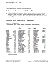
From the highest high to the lowest low here's a resource that won't fall flat. Given data on the area and the highest and lowest elevations of each of the 50 states, learners decide which states are the least flat and the most flat. Of...
DocsTeach
Lewis and Clark's Expedition to the Complex West
Lewis and Clark's famous expedition is a prime example of the United States' westward expansion. Aspiring historians examine maps from Lewis and Clark's journey, as well as discuss their interactions with Native American tribes. The...
Sharp School
Travel Brochure Project
Designing a travel brochure is a classic project that will help your class members develop a variety of skills, such as researching informational texts, designing creative visual products, and communicating what you have learned.
PBS
What's In a Name?
What is in a name? Eager historians trace the geographical history of places in the United States with Spanish names. Using a worksheet activity, clues, and web research developed in conjunction with the PBS "Latinos in America" series,...
Curated OER
Texas Commemorative Maps: Honoring Our Past
To celebrate Texas, groups plan and create a commemorative map for a topic or theme in Texas history. The richly detailed plan and the approach could easily be adapted to any state. Samples are included.
Houghton Mifflin Harcourt
One Land, Many Trails: Challenge Activities (Theme 5)
Bring history to life through literature. The first in a series of three challenge activities designed to accompany Theme 5: One Land, Many Trails does just that through unique projects connected to historical fiction and nonfiction...
Houghton Mifflin Harcourt
One Land, Many Trails: Extra Support Lessons (Theme 5)
Grammar, vocabulary, and comprehension strategies are all part of the journey toward understanding a text. The last in a series of three extra support lessons designed to accompany Theme 5: One Land, Many Trails provides a wealth of...
Other popular searches
- State Political Maps
- State of Georgia Maps
- State Outline Maps
- State and Local Maps
- State Outlines Maps

