Space Awareness
Let's Map the Earth
Before maps went mobile, people actually had to learn how to read maps. Pupils look at map elements in order to understand how to read them and locate specific locations. Finally, young cartographers discover how to make aerial maps.
Teach Engineering
What is GIS?
Is GIS the real manifestation of Harry Potter's Marauders Map? Introduce your class to the history of geographic information systems (GIS), the technology that allows for easy use of spatial information, with a resource that teaches...
Compton Unified School District
How Can We Locate Places?
How can we locate places? Maps, of course! Expose second graders to the tools available in maps and discuss how these tools can help people find locations. Students also look at communities, including what makes a community and the...
CK-12 Foundation
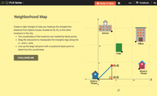
Pythagorean Theorem to Determine Distance: Neighborhood Map
Find the distance between various locations in a neighborhood. Scholars use the interactive to find distances between locations on a map. The map is overlaid onto a grid to provide coordinates for each location, and pupils apply...
K-State Research and Extensions
Water
How are maps like fish? They both have scales. The chapter includes six different activities at three different levels. Scholars complete activities using natural resources, learn how to read a map, see how to make a compass rosette,...
American Museum of Natural History
Map Your Own World
Young archaeologists practice their mapping skills by creating a detailed site map of their room or another room in their home. After indicating walls, windows, doors, and closets, they add furniture and objects, labeling each item.
NASA
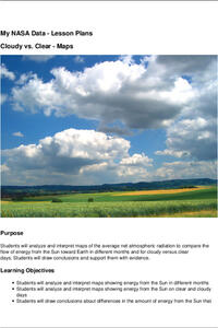
Cloudy vs. Clear - Maps
Find out the science of how clouds keep Earth cooler on hot days. Using guided discussions, investigators analyze and interpret maps of how much solar energy Earth receives at different times of the year. Participants draw conclusions...
Curated OER
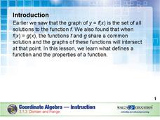
Domain and Range
Relations, and functions, and line tests, oh my! An instructional slideshow demonstrates the definitions of a relation, a function, and the domain and range of a relation. Viewers then learn how to use mappings and vertical line tests to...
Student Achievement Partners
You've Been Lied To: The REAL Christopher Columbus
Looking for resources that explore alternative perspectives of the Christopher Columbus story? Check out the images, videos, cartoons, primary source documents, and other texts in a packet designed to spark debate.
Bill of Rights Institute
America's Transition to a Global Economy (1960s-1990s)
Just how do we live in a global society? Scholars investigate an AP review video to see the transition in the latter half of the 20th century to a global economy. The final video of nine installments helps them examine and analyze the...
Polar Trec
Playground Profiling—Topographic Profile Mapping
The Kuril islands stretch from Japan to Russia, and the ongoing dispute about their jurisdiction prevents many scientific research studies. Scholars learn to create a topographic profile of a specific area around their schools. Then they...
Bulgarian Creative Writing Competition
Creative Writing Workshop
Looking for suggestions on how to organize a creating writing workshop? For topic suggestions appropriate for various grade levels? Check out a resource packet, designed for English language arts instructors, that is packed with ideas...
Corbett Maths
Enlargements with Fractional Scale Factors
Enlargements make it bigger, right? A video shows viewers how to perform a basic dilation with a fractional scale factor. They learn how to use the scale factor to find the location of the transformed vertex by multiplying the horizontal...
University of North Carolina
Summary: Using it Wisely
Sometimes summarizing keeps a writer from going deeper into their analysis—don't fall into that trap. Learn the difference between summarizing and analyzing using an insightful resource. Focusing on introductions, the lesson shares...
Mary Pope Osborne, Classroom Adventures Program
The Backpack Travel Journals
Strap on those backpacks, it's time to travel through history with this literature unit based on the first four books of The Magic Tree House series. While reading through these fun stories, children create story maps, record interesting...
National Woman's History Museum
Sacagawea
Mind maps are great tools. Teach your classes how to use mind maps to collect, organize, and retain information with a instructional activity that asks learners to research the life of Sacagawea and use mind maps to record their findings.
ESRI
Juneteenth: An American History through Maps
An interactive website traces the history of Juneteenth celebrations from their origin in Galveston, Texas, on June 19th to the present day. Using interactive maps, learners can find information about the African-American population...
Newseum
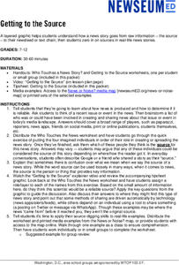
Getting to the Source
Reliable news stories are based on facts from reliable sources. Young journalists learn how to evaluate the reliability of news sources by watching a short explainer video. Teams apply their new source-digging skills to a current news...
Orange County Water Atlas
Location, Location, Location…
Young geographers discover not only how to read and recognize coordinates on a map, but also gain a deeper understanding of latitude and longitude and how climate changes can vary significantly across latitudes.
CK-12 Foundation
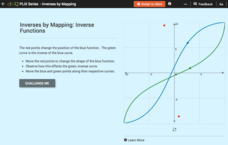
Inverses by Mapping: Inverse Functions
Map your way to successfully understanding inverse functions. Pupils use an interactive map to investigate how changes in the graph of a function affect the graph of its inverse. The results of the activity lead to the conclusion that...
TED-Ed
A Digital Reimagining of Gettysburg
Why would Robert E. Lee order Pickett's Charge, an action that changed the course of the Civil War? Geographer and historian Anne Knowles uses digital technology to explain what she thinks is the missing piece in trying to understand...
Teach Engineering
Projections and Coordinates: Turning a 3D Earth into Flatlands
Introduce your class to map projections and coordinates, the basics for the work done in a GIS, with an activity that uses Google Earth to challenge learners to think about the earth's shape.
Penguin Books
A Teacher's Guide to the Signet Classics Edition of Cyrano de Bergerac by Edmond Rostand
Edmond Rostand's Cyrano de Bergerac has enjoyed popularity since its debut in 1897 due in large part to the themes it addresses. Instructors planning on using the play with their classes will find much to like in this teaching guide. The...
Civil War Trust
Map the Civil War
Mapmaking was a very important element in successfully planning attacks on enemies during the Civil War. Guide pupils through the process of pacing to find the average length of their steps, measure the distance between one object to the...


