Teach Engineering
Who Can Make the Best Coordinate System?
Working with a map that does not have a coordinate system on it, small, collaborative teams must come up with a coordinate system for their map. Groups then explain their coordinate structure to the class.
Polar Trec
Playground Profiling—Topographic Profile Mapping
The Kuril islands stretch from Japan to Russia, and the ongoing dispute about their jurisdiction prevents many scientific research studies. Scholars learn to create a topographic profile of a specific area around their schools. Then they...
Radford University
Getting Around Millbrook
When is the distance formula not accurate? Referencing a map of the school, pairs determine the walking distance between two locations. Creating coordinates for each location, pupils determine the distance between the two points and...
EngageNY
Similarity
Use the coordinate plane to show two figures are similar. The lesson incorporates congruence transformations and dilations to move a figure on to another figure. Pupils determine that if a similarity transformation exists...
Mathematics Vision Project
Module 7: Connecting Algebra and Geometry
The coordinate plane links key geometry and algebra concepts in this approachable but rigorous unit. The class starts by developing the distance formula from the Pythagorean Theorem, then moves to applications of slope. Activities...
Curated OER
What's Your Temperature?
Learners take a look at the local newspaper and focus on the weather section. They get into small groups, and each one looks at the same map, but of a different part of the country. They must prepare a presentation that shows how...
EngageNY
Informal Proofs of Properties of Dilations
Challenge the class to prove that the dilation properties always hold. The lesson develops an informal proof of the properties of dilations through a discussion. Two of the proofs are verified with each class member performing the...
EngageNY
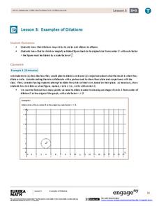
Examples of Dilations
Does it matter how many points to dilate? The resource presents problems of dilating curved figures. Class members find out that not only do they need to dilate several points but the points need to be distributed about the entire curve...
Radford University
Finding a Location for Your Kitchen Island
Where is the best place to work? Small groups map out a kitchen on a coordinate plane and find the centers of the work triangle to find the best place to install an island. The teams use algebraic methods to locate the center by finding...
EngageNY
The Geometric Effect of Some Complex Arithmetic 1
Translating complex numbers is as simple as adding 1, 2, 3. In the ninth lesson in a 32-part series, the class takes a deeper look at the geometric effect of adding and subtracting complex numbers. The resource leads pupils into what it...
Illustrative Mathematics
Why Does SSS Work?
While it may seem incredibly obvious to the geometry student that congruent sides make congruent triangles, the proving of this by definition actually takes a bit of work. This exercise steps the class through this kind of proof by...
Mathematics Assessment Project
Sorting Equations of Circles 2
How much can you tell about a circle from its equation? This detailed lesson plan focuses on connecting equations and graphs of circles. Learners use equations to identify x- and y-intercepts, centers, and radii of circles. They also...
Space Awareness
How To Travel On Earth Without Getting Lost
Have you ever wanted to travel the world? Take a virtual trip with a geography lesson that uses longitude and latitude, the position of the sun, an astronomy app, and a classroom globe.
MARS, Shell Center, University of Nottingham
Defining Regions Using Inequalities
Your young graphers will collaboratively play their way to a better understanding of the solution set produced by the combining of inequalities. Cooperation and communication are emphasized by the teacher asking questions to guide the...
Curated OER
Radiation Comparison Before and After 9-11
Using the NASA website, class members try to determine if changes could be detected in cloud cover, temperature, and/or radiation measurements due to the lack of contrails that resulted from the halt in air traffic after the attacks...


