Ed Helper Clip Art
USA States
Looking for a map of the Unites States of America? Look no further than this printable map designed to accompany your geography instruction and to give map skills a boost.
K12 Reader
United States Geography
Encourage reading for information with a text about United States geography. Kids read a short passage about the landforms in the United States, including mountain ranges and natural resources, and answer five reading comprehension...
Curated OER
United States Regions
In this United States political map instructional activity, students examine regional census boundaries of the US. State boundaries are also included.
Curated OER
Landforms and Resources of the United States and Canada
In this North American geography activity, students read about the physical features and resources of the United States and Canada. Students take notes and answer 3 short answer comprehension questions as they read the selection.
Curated OER
The United States and Canada: Climate and Vegetation
Display U.S. and Canadian climate and vegetation through this text-companion worksheet. Learners read about the geography of these regions, take notes, and answer 3 comprehension questions as they read the selection. A graphic organizer...
Little 10 Robot
Geography Drive USA™
A trivia-style virtual road trip in which the player's car is moved from state to state as questions are correctly answered. Ideally, a player would learn about different states by reading the simple brochures available in the...
University of Richmond
Canals 1820-1860
While canals are not a common mode of transportation today, they were part of the fuel for America's industrialization. However, most of them were located in the North, also feeding regional differences and sectionalism. Using an...
Curated OER
Southern States Word Search
Sixteen of our southern states are hidden in this basic word search. Learners must find words that are hidden in every way possible within the search - even backwards! Luckily, an answer key does accompany this resource.
Curated OER
United States of America
In this writing instructional activity, students read short paragraphs about United States facts. Students then generate questions about the paragraphs using given facts.
CK-12 Foundation
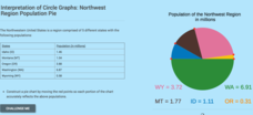
Interpretation of Circle Graphs: Northwest Region Population Pie
Given populations of the five Northwestern states, learners create a circle graph. Using the data and the pie chart, they make comparisons between the populations of the states. Finally, the pupils determine how the chart will change...
Curated OER
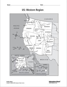
US: Western Region Map
For this United States Western Region worksheet, students examine the state boundaries and landforms found in this region. The map also highlights each of the state capitals.
Curated OER
South US Region Map
In this United States regional outline map, students examine the state boundaries of the states in the Southern Region. Capital cities are denoted with stars.
K12 Reader
Eastern Woodland Natives
Supplement your social studies instruction with a reading passage about the Eastern Woodlands. After reading the passage, learners respond to five related questions.
Curated OER
State Cards
In this state cards worksheet, students cut out 9 cards, each of which has a picture of one state in the United States on it. These states are all located in the Midwest and Northwest regions. These cards could be used for a matching game.
Curated OER
U.S. Geography for Children: State Capitals
In this United States map skills worksheet, students locate and label specified states and their capitals, and create icons and a map key to show something for each state that is famous. Students answer 5 questions.
Curated OER
Eastern States Word Search
In this geography word search worksheet, students locate and circle the 13 states located in the Eastern region of the United States. A word bank is provided.
Curated OER
Western States Word Search
In this geography word search instructional activity, students locate and circle the 11 states located in the Western region of the United States. A word bank is provided.
Curated OER
New Mexico
In this New Mexico worksheet, students read a two page text about the history of the state of New Mexico. Students answer ten true and false questions.
Curated OER
South US Region
For this United States political map worksheet, students examine the Southern Region state boundaries. The map also highlights each of the state capitals denoted by stars. The states, capitals and major landforms are labeled.
Curated OER
US: Midwest Region
In this United States political map learning exercise, students examine the state boundaries of the Midwestern Region. The map also highlights each of the state capitals denoted by stars.
Curated OER
US: Northeast Region Map
In this United States political map worksheet, students examine the state boundaries of the Northeast Region. The map also highlights each of the state capitals denoted by stars.
Curated OER
US: Northeast Region: Unlabelled
In this United States political map activity, students examine the Northeast Region state boundaries. The map also highlights each of the state capitals denoted by stars.
Curated OER
Travel T-Shirts U.S. Regions Activity
In this U.S. regions worksheet, students create a T-shirt logo for each of the 8 regions of the United States.
K12 Reader
National Symbols
What are the most prominent symbols of the United States? Learn about the bald eagle, the American flag, and the Statue of Liberty in a reading comprehension activity that includes a short passage and five reflective questions.


