Curated OER
North America Outline Map
In this blank North America outline map worksheet, students study the political boundaries of the continent. This outline map may be used for a variety of geographic activities.
Curated OER
North America Map Quiz
In this online interactive geography quiz activity, students respond to 19 identification questions about the countries located in North America.
Curated OER
Major Lakes of North America
In this North American learning exercise, high schoolers explore the locations of the major lakes on the continent. The map may be used for a variety of geography lessons.
Curated OER
North America
In this map of North America worksheet, students study the map of North America and then write the names of the 11 countries on the provided lines.
Curated OER
North America Capitals Map Quiz
In this online interactive geography quiz worksheet, students respond to 16 identification questions regarding capital cities of North American countries.
Curated OER
North American Rivers Map Quiz
For this online interactive geography quiz worksheet, learners examine the map that includes 13 rivers in North America. Students match the names of the rivers to the appropriate places on the map.
Curated OER
Geography Words, Page 1
In this geography words and maps worksheet, students examine maps of North and South America. Students respond to 12 multiple choice questions regarding the maps.
Devine Educational Consultancy Services
Geography Student Workbook, Australia
Your youngsters will be experts on the geography of Australia after working with these activities and worksheets, which review the continent's weather, major landforms, dimensions, history, and climate.
Curated OER
Americas: Political Map
In this North America and South America outline map worksheet, students examine the political boundaries of the 2 continents.
Curated OER
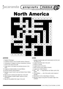
North America Puzzle
For this geography worksheet, students complete a crossword puzzle in reference to North America. They identify capitals of some countries, the specific landforms of different areas, and languages spoken. There are 21 clues to solving...
Curated OER
North America Puzzle Answer Sheet
In this geography worksheet, students name the capitals of various countries found in North America. They also identify the various weather patterns across the continent and specific bodies of water. There are 21 descriptions and 21...
Curated OER
World Map Labels
In this geography skills worksheet, students identify the countries and bodies of water labelled on the maps of the world, Africa, Asia, Canada, Europe, the Caribbean, the Middle East, North America, Australia, and South America.
Curated OER
Where in the World is Mrs. Waffenschmidt? #23
Mrs. Waffenschmidt is hanging out at the Paricutin Volcano in Mexico. But your class won't know that until after they read the fact-filled paragraph that divulges her location. Each sheet includes two sections to be cut and handed out....
K12 Reader
Conflict Over North American Lands
Readers are introduced to some of the conflicts that arose over land and resources in the Americas in a two-part cross-curricular comprehension worksheet that asks kids to study the article and then to use information provided to...
Curated OER
North American Mountain Ranges Map Quiz
In this online interactive geography quiz worksheet, students respond to 7 identification questions regarding North American mountain ranges.
Curated OER
The Geography of Russia
In this geography of Russia learning exercise, students read a 4 page article about the geography of Russia and complete short answer questions and assignments based on the article. Students complete 6 assignments.
Curated OER
World Map
In this world map worksheet, students practice their geography skills as they label the 7 continents and 5 oceans. A word bank in included.
Richmond Community Schools
Map Skills
Young geographers will need to use a variety of map skills to complete the tasks required on this worksheet. Examples of activities include using references to label a map of Mexico, identify Canadian territories and European...
Curated OER
Geography Words
This worksheet uses maps of South America and Canada to combine basic geography vocabulary and using prepositions. Students use the maps to answer questions about the locations of various countries on the two maps. This would be a good...
Curated OER
Americas: Physical Map
In this Americas physical map worksheet, students make note of the major landforms and bodies of water located on the North American and South American continents.
Curated OER
Number The Stars Geography
In this social studies activity, students look for the location of Denmark and then color the continents of Europe and North America.
PBS
NASA's Eyes on the 2017 Eclipse
How did the 2017 eclipse look in Los Angeles—or Chicago? Experience both views, plus many more, using a lesson from PBS's Space series for middle schoolers. Scholars follow the movements of the sun, moon, and Earth during the most recent...
New York State Education Department
US History and Government Examination: August 2010
Geography has played a complex role in America history. The Atlantic Ocean has served as a buffer to protect the United States from European Wars, but its proximity to Cuba, however, left it vulnerable to nuclear war during the Cuban...
Curated OER
Endangered Species
In this geography worksheet, learners identify how to manipulate data on a range of endangered species. They create a bar graph of endangered animals from Africa, Asia, Australia, North America, or South America. Students use a...
Other popular searches
- North America Geography
- North American Geography
- North America World Geography
- Geography North America Maps


