K12 Reader
United States Geography
Encourage reading for information with a text about United States geography. Kids read a short passage about the landforms in the United States, including mountain ranges and natural resources, and answer five reading comprehension...
Curated OER
United States Regions
In this United States political map instructional activity, students examine regional census boundaries of the US. State boundaries are also included.
Curated OER
Landforms and Resources of the United States and Canada
In this North American geography activity, students read about the physical features and resources of the United States and Canada. Students take notes and answer 3 short answer comprehension questions as they read the selection.
CK-12 Foundation
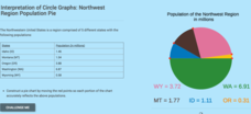
Interpretation of Circle Graphs: Northwest Region Population Pie
Given populations of the five Northwestern states, learners create a circle graph. Using the data and the pie chart, they make comparisons between the populations of the states. Finally, the pupils determine how the chart will change...
Curated OER
United States of America
In this writing instructional activity, students read short paragraphs about United States facts. Students then generate questions about the paragraphs using given facts.
K12 Reader
Eastern Woodland Natives
Supplement your social studies instruction with a reading passage about the Eastern Woodlands. After reading the passage, learners respond to five related questions.
Curated OER
U.S. Geography for Children: State Capitals
In this United States map skills worksheet, students locate and label specified states and their capitals, and create icons and a map key to show something for each state that is famous. Students answer 5 questions.
K12 Reader
National Symbols
What are the most prominent symbols of the United States? Learn about the bald eagle, the American flag, and the Statue of Liberty in a reading comprehension activity that includes a short passage and five reflective questions.
Humanities Texas
Primary Source Worksheet: George Washington, Farewell Address
Invite your young historians to consider how the first president of the United States envisioned the future of the new nation with this primary source analysis worksheet on George Washington's Farewell Address.
Curated OER
Constitutional Acts (Chapter 3)
Help your students review constitutional acts in this review worksheet, which could also be used as a class quiz. Five matching questions and five multiple choice questions address checks and balances, the powers of the Senate and House,...
National Wildlife Federation
Hot, Hotter, Hottest: Extreme Weather's Impact on Our Resources
How dry is it? It's so dry, the river only runs twice a week! Through an analysis of maps and discussions, pairs learn about droughts across the United States in the ninth of 12 lessons. They then read about, answer questions, analyze...
Curated OER
Climate Types
For this weather worksheet, students identify the type of vegetation found in particular regions across the United States. Then they list the six groups of climates in the Köppen Classification System. Students also describe the...
Curated OER
King Andrew And His Critics
In this United States history worksheet, students utilize a word bank of 10 terms or phrases to answer 10 fill in the blank questions about the Andrew Jackson and his critics. A short answer question is included as well.
K12 Reader
Taiga Ecosystems
Introduce your class to another type of ecosystem, the taiga ecosystem, through a reading passage. Class members read the text and then respond to five reading questions about the content of the passage.
Chicago Botanic Garden
Climate Change Impacts on Ecosystem Services
The fourth activity in a series of five has classes participate in a jigsaw to learn about global impacts of climate change and then share their new information with a home group. Groups then research impacts of climate change (droughts,...
K12 Reader
Chaparral Ecosystems
Explore the impact of wildfires with a reading passage about ecosystems. Pupils read the passage and respond to five questions related to the content of the text.
Curated OER
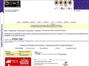
Pennsylvania Vocabulary Word Jumble
For this Pennsylvania worksheet, students unscramble the letters in 20 words to spell key cities, people, resources or regions in the state of Pennsylvania. There is a word bank.
Curated OER
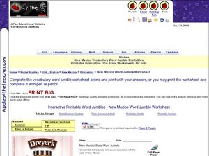
New Mexico Vocabulary Word Jumble
In this New Mexico worksheet, students unscramble the letters in 20 words to spell key places, people, resources or regions of the state of New Mexico. There is a word bank provided.
Curated OER
Temperature Line Graphs
In this temperature learning exercise, students create 3 line graphs from data tables showing dates and recorded temperatures. This learning exercise includes an answer key.
Curated OER
Alaska
In this Alaska worksheet, students complete 6 pages of readings and questions about the state of Alaska. Included are general facts, First Nation groups, European arrival, industry and people. Each page has a short text and 6 multiple...
Curated OER
Eisenhower & the New Modern Republicanism (5)
In this online interactive history worksheet, students respond to 10 matching questions regarding the presidency of Eisenhower and New Modern Republicanism. Students may check their answers immediately
Humanities Texas
Primary Source Worksheet: Theodore Roosevelt, Excerpt from “The Square Deal” Speech
Talk about a timely resource! As part of a series of primary source exercises, individuals read and respond to questions about Theodore Roosevelt's "The Square Deal" speech. Roosevelt reminds us of what our social system should be.
Mathematics Vision Project
Module 5: Modeling with Geometry
Solids come in many shapes and sizes. Using geometry, scholars create two-dimensional cross-sections of various three-dimensional objects. They develop the lesson further by finding the volume of solids. The module then shifts...
Curated OER
U.S. Geography for Children: The Northeast
In this map skills of the northeastern United States learning exercise, learners observe an outline map, locate and label the states, and designated landforms and bodies of water; and create symbols and a map key for sources of economy...


