Other
Percentage of the World's Population Under Various Political Systems
Time-line graphs and maps give visual representations of countries and populations under various kinds of political systems: autocracy, monarchy, communist state, etc.
Other
Metrocosm: How We Share the World
In this geographic interactive, students can visualize the world via the following six ways: GDP, government debt, population, births, wealth and billionaires.
Other
Population Reference Bureau: The World at 7 Billion
This interactive map offers statistical data on population, birth and deaths, life expectancy, HIV/AIDS, family planning, and poverty across the world in 2011. The information is also available as a table for all topics. A fascinating...
Other
Fiarfield University: The Urbanization of the World
A focused look at urbanization in first and third world societies . Interesting charts compare urbanization trends in more vs. less developed regions of world.
BBC
Bbc News: Disposable Planet
The Earth's population is soaring, but its resources are finite. Can we provide food, water, energy? Watch a slideshow on our planet's future, and take a quiz to measure your impact on the Earth.
Other
Mr. Dowling's Passport: Life Expectancy Around the World
From the CIA World Fact Book, this chart displays life expectancy statistics by country. Also links to data from the last two years.
Houghton Mifflin Harcourt
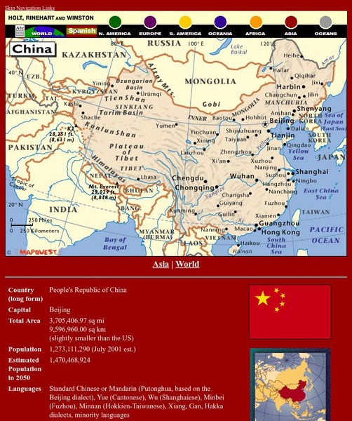
Holt, Rinehart and Winston: World Atlas: China
See a map of China and surrounding countries, and get basic facts and stats about China: capital, total area, population, languages, and more.
Houghton Mifflin Harcourt
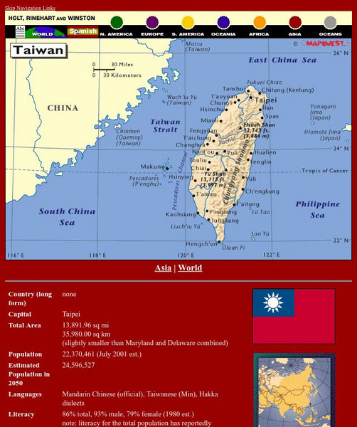
Holt, Rinehart and Winston: World Atlas: Taiwan
Grab quick facts about Taiwan (capital, total area, population, languages, literacy, religions, government, currency, industry, and more) while looking at a map, complete with cities, elevations, bodies of water, longitude, and latitude....
Other
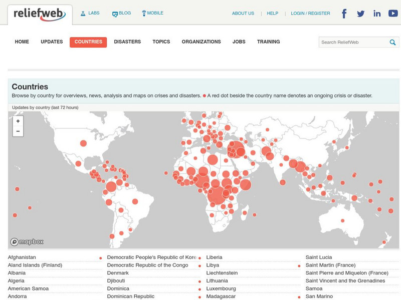
Relief Web: Countries
This resource provides information on countries throughout the world, current news, and different types of maps.
Curated OER
Etc: Maps Etc: Population Distribution of Asia, 1921
A base map of Asia from 1921 showing the general population distribution of the region at the time. "The climate of southeastern Asia is so warm and moist that food plants grow there in abundance. Nearly half the people of the world live...
Curated OER
Animated Map of Human Population
This animated map shows world population growth from the year 1 to 2020 A.D. Note the changing years as you observe the growth on a map of the world.
Other
Islam Project: Maps
A series of historical and near-present-day maps that span Islamic history. Starting with A.D. 750, the maps illustrate both the spread of Islam (from Medina outward to Africa, the Middle East, Europe, and other parts of the world) and...
Other
Matthew White: Historical Atlas of the Twentieth Century
An interactive atlas of the world, The different maps show how the governments, populations, socio-economic trends, and religions have changed over time throughout the world.
Curated OER
Etc: Maps Etc: Cities and Towns of the United States, 1898
A map from 1898 of the contiguous 48 states showing the distribution pattern of the major cities and towns at the time. The size of the dots indicate comparative populations. "Most of the manufacturing of the world is carried on in...
Curated OER
Unesco: Palau: Rock Islands Southern Lagoon
Rock Islands Southern Lagoon covers 100,200 ha and includes 445 uninhabited limestone islands of volcanic origin. Many of them display unique mushroom-like shapes in turquoise lagoons surrounded by coral reefs. The aesthetic beauty of...
Curated OER
Unesco: Colombia: Malpelo Fauna and Flora Sanctuary
Located some 506 km off the coast of Colombia, the site includes Malpelo island (350 ha) and the surrounding marine environment (857,150 ha). This vast marine park, the largest no-fishing zone in the Eastern Tropical Pacific, provides a...
Curated OER
Unesco: India: Kaziranga National Park
In the heart of Assam, this park is one of the last areas in eastern India undisturbed by a human presence. It is inhabited by the world's largest population of one-horned rhinoceroses, as well as many mammals, including tigers,...
Curated OER
Unesco: Canada: Wood Buffalo National Park
Situated on the plains in the north-central region of Canada, the park (which covers 44,807 km2) is home to North America's largest population of wild bison. It is also the natural nesting place of the whooping crane. Another of the...
Curated OER
Unesco: New Zealand: New Zealand Sub Antarctic Islands
The New Zealand Sub-Antarctic Islands consist of five island groups (the Snares, Bounty Islands, Antipodes Islands, Auckland Islands and Campbell Island) in the Southern Ocean south-east of New Zealand. The islands, lying between the...
Curated OER
Unesco: Kenya: Kenya Lake System in the Great Rift Valley
The Kenya Lake System in the Great Rift Valley , a natural property of outstanding beauty, comprises three inter-linked relatively shallow lakes (Lake Bogoria, Lake Nakuru and Lake Elementaita) in the Rift Valley Province of Kenya and...
Curated OER
Unesco: Mexico: Historic Centre of Mexico City and Xochimilco
Built in the 16th century by the Spanish on the ruins of Tenochtitlan, the old Aztec capital, Mexico City is now one of the world's largest and most densely populated cities. It has five Aztec temples, the ruins of which have been...
Curated OER
Unesco: Indonesia: Cultural Landscape of Bali Province
The cultural landscape of Bali consists of five rice terraces and their water temples that cover 19,500 ha. The temples are the focus of a cooperative water management system of canals and weirs, known as subak, that dates back to the...
Curated OER
Unesco: Cameroon: Sangha Trinational
Situated in the north-western Congo Basin, where Cameroon, Central African Republic and Congo meet, the site encompasses three contiguous national parks totalling around 750,000 ha. Much of the site is unaffected by human activity and...


