Hi, what do you want to do?
Curated OER
And Your Point Is . . .? Part I
Students, in groups, complete a WebQuest titled "Love Canal Debate". They follow the WebQuest to research and write papers on different points of view regarding the Love Canal environmental disaster.
Curated OER
Parliamentary Structure and Process on " Deck"
Tenth graders design a "deck" of individual slides on Power Point to synthesize, in a graphic organizer, their recently acquired knowledge of different levels of government in Canada.
Curated OER
Prescription For Survival
Students engage in a instructional activity that is focused upon the survival of populations located in third world countries. They conduct research using a variety of resources while focusing upon the delivery of healthcare with the...
Curated OER
Yi Peoples--Sanctioning Taboo In China
Students identify the minority and ethnic groups in China. Using the internet, they discover the types of languages spoken and research the policies in place to manage minorities. In groups, they role-play the different ethnic groups...
Curated OER
Human Rights Squares
Students read the Universal Declaration of Human Rights (UDHR) and then participate in an activity in which they discuss instances where human rights have been violated.
Curated OER
Militia of the American Revolutionary War
Students explore the role of the colonial militia n the American Revolutionary War. Using traditional and internet resources, students, complete a research worksheet designed to provide information about the militia. Worksheet is...
Curated OER
Lesson Plan on Important Citizens in the American Civil War
Learners, in groups, half representing the Confederacy, half the Union, conduct research to find out about important Civil War era citizens from each side. They explore the effect these people had on the war and what effect the war had...
Curated OER
Lesson Plan on Military Leaders in the American Civil War
Students, in groups, half representing the Confederacy, half the Union, conduct research to find out about important Civil War military leaders from each side. They find the answers to a variety of questions regarding their military...
Curated OER
Breaking News English: Prisoners
In this North Pole worksheet, students read the article, answer true and false questions, complete synonym matching, complete phrase matching, complete a gap fill, answer short answer questions, answer discussion questions, write, and...
The Newberry Library
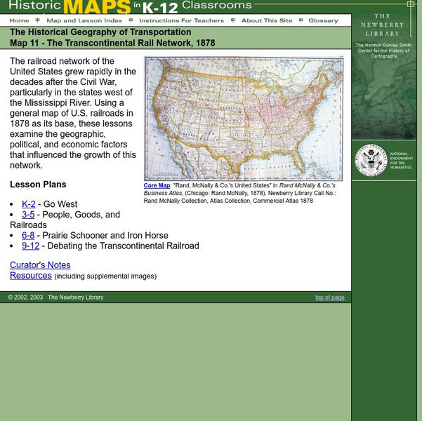
Newberry: Historical Geography: Map 11: The Transcontinental Rail Network, 1878
Lesson for K-12 using historical maps examine the geographic, political, and economic factors that influenced the growth of railroads.
United Nations
United Nations: Cartographic Section: The World Today [Pdf]
Here is an up-to-date political map of the world today. Very detailed with a good key.
Other
Just Maps: World Maps
An index of maps and flags of countries throughout the world. Also provides political maps, time zones, population, and religious maps of every region of the world.
The Newberry Library
Newberry: Political and Military History: Map 15: The World at War, 1944
Lesson for K-12 using historical map teaches students about the relationship between perspectives of the world and map projections.
Latimer Clarke Corporation
Altapedia Online: World Map Resources
Features downloadable World Political and Physical Maps that include country names, country borders, ocean features, island names, and lat/long graticules. Clicking on any part of the map enlarges it.
Other
Ohio Wesleyan University: World Political Boundaries
This site has a photograph of a detailed, colorful map of political boundaries around the world with a zoom feature for a closer look. A brief description of how economic boundaries relate to political ones.
Latimer Clarke Corporation
Atlapedia: World Maps/middle East
Learn the locations and countries in the Middle East from this political map. Click on the link at the top of the page to see a physical map of the same region. Clicking on the country's name will take you to information about that country.
United Nations
United Nations: Cartographic Section: The World in 1945 [Pdf]
Find out what the political world map looked like after World War II in 1945. Enlarge the map so you can see what countries belonged to the UN, which were still dependent territories, and which did not belong to the UN.
E-learning for Kids
E Learning for Kids: Math: Bus Station: Position on a Map
Help Jamal read maps, describe directions, and identify coordinates in this series of interactive exercises.
University of Oregon
Mapping History: American History
Interactive and animated maps and timelines of historical events and time periods in American history from pre-European times until post-World War II.
University of Texas at Austin
The Perry Castaneda Library Map Collection
This collection contains more than 250,000 maps covering all areas of the world, and ranging from political and shaded relief maps to the detailed and the historical. Select from a region of the world or an area of highlighted interest.
PBS
Pbs: Geography of Music the World in the Age of Revolutions
This interactive map helps illuminate the relationships among the various composers as well as connections between music and its historical and cultural context. It also illustrates the importance of the physical and cultural...
Central Intelligence Agency
Cia: World Factbook: Jamaica
This resource from the CIA World Factbook provides a detailed fact sheet of Jamaica. The content covers the country's geography, people, government, economy, communications, transportation, military, and transnational issues. It includes...
Central Intelligence Agency
Cia: World Factbook: Japan
This resource from the CIA World Factbook provides a detailed fact sheet of Japan. The content covers the country's geography, people, government, economy, communications, transportation, military, and transnational issues. It includes...
Latimer Clarke Corporation
Atlapedia Online
This site provides both physical and political maps of countries of the world in full color. Also contains key facts and statistics.
Other popular searches
- Political Map of World
- Blank World Political Map
- World Political Map Labeled
- Political Map of the World


![United Nations: Cartographic Section: The World Today [Pdf] Graphic United Nations: Cartographic Section: The World Today [Pdf] Graphic](https://static.lp.lexp.cloud/images/attachment_defaults/resource/large/FPO-knovation.png)

