Curated OER
Warm Thoughts About the Cold
“What do you think life is like at the South Pole?” After responding to this journal prompt, class members read and discuss the New York Times article, “At South Pole, New Home for a New Era.” Using resources available from the Times’...
Curated OER
World Map and Globe-Equator, North Pole, and South Pole
Students identify the Equator, North Pole, and South Pole on a map. For this geography lesson, students use a world map and circle the North and South Pole. Students locate the Equator on a globe and use a map marker to highlight it.
Curated OER
North And South Pole Venn Diagram
In this compare and contrast worksheet learners use a Venn diagram. Students compare and contrast the North Pole and the South Pole. No information is provided.
Curated OER
Polar Explorers-Sir Ernest Shackleton
Students discuss Sir Ernest Shackleton and his participation in the Discovery expedition in 1901 to the South Pole. Students write a persuasive letter of application to an ad Shackleton placed in a London newspaper looking for recruits...
National First Ladies' Library
Brrrr! Expeditions to the North and South Poles
Students examine the first successful explorations of the North and South Poles, through a study of the four men who accomplished them. They present the fruits of their research on posters, or with PowerPoint presentations.
Curated OER
Earth's Features
In this geography learning exercise, students label a map of the world with the Arctic Circle, Tropic of Capricorn, Tropic of Cancer, Equator, North Pole, South Pole, and the Antarctic Circle.
Curated OER
Equator, North Pole, and South Pole
Students identify the Equator, North Pole, and South Pole on the globe. In this map skills lesson, students use a globe marker to locate specific locations on the globe. Students find where they live in relation to the Equator.
Curated OER
World Map and Globe - Four Main Directions
Students study the four main directions on a map. In this map lesson, students locate the North and South pole, and learn the four cardinal directions. They use the compass rose on a map to help with the directions. (Map is not included...
Curated OER
United States Map - Lesson 7: Four Main Directions
Students locate the North and South Poles, and learn the definitions of the four directions by using a United States Map and a globe. In this directions lesson plan, students define north, south, east, and west on a map and a globe.
Curated OER
Antarctica I
Students explore exploring and expiditions then simlate their own on campus. They divide into small "expedition groups." Have each team report back to the class about their expeditions, using written, oral, or videotaped presentations.
Curated OER
Four Main Directions
Students describe directions using a globe for north, east, south and west. In this mapping lesson plan students identify the north and south pole. Students understand the importance of the equator and the Prime Meridian. Students...
Curated OER
United States Map
Students access prior knowledge and locate the North and South Poles on the map. In this mapping lesson, students understand the position of the United States relative to the poles. Students answer questions about the globe.
Curated OER
Maps and Globes: Where in the World are We?
Students explore maps and globes. In this introduction to map and globe concepts lesson, students identify features of physical maps, political maps, and globes. Students locate land and water, and recite a poem about the names of the...
Curated OER
Polar Expeditions
Middle schoolers consider the implication of polar exploration. In this polar exploration lesson, students research the expeditions that Admiral Peary, Dr. Cook, Captain Scott, and Roald Amundsen made to the North and South Poles. Middle...
Curated OER
Day and Night
In this day night compare and contrast worksheet, students examine a picture of the earth and of the sun labeling day, night, equator, sun, North Pole, and South Pole.
Curated OER
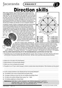
Direction Skills
In this geography worksheet, students read an excerpt on what directions tell someone. They respond to 6 short answer questions related to the neighborhood illustration found on the second page of the worksheet.
Curated OER
Color the Hemispheres
In this Earth's hemispheres and poles worksheet, students color the North Hemisphere blue and the South Hemisphere red. Students then label the equator, the north pole, and south pole.
Curated OER
Exploiting Antarctica
Middle schoolers read the story and diary "Lizzie's diaries from Antarctica and Antarctica" to get massive clean-up. Students discuss their knowledge of life in Antarctica and raise the fact of the Amundsen-Scott South Pole Station and...
Curated OER
Rising Sea Levels: UK and Bangladesh
Students explore the possible effects of global warming. In this geography/global warming lesson, students identify regions using an atlas and complete a global warming worksheet. Students perform an experiment in which they simulate...
Curated OER
Why Amundsen Killed His Dogs
Middle schoolers use Internet, video and text resources to gather information about the Amundsen/Scott race for the South Pole in 1911-12, dog sledding, and the ethical treatment of animals for science. They set up a debate to determine...
Curated OER
We've got the whole world in our hands
Students explore spatial sense in regards to maps about the globe. In this maps lesson plan, students label oceans, locate the continents and poles, follow directions, and explain the symbols on a map.
Curated OER
Give Me Some Latitude
For this latitude worksheet, students use an atlas or other reference to respond to 4 multiple choice questions about the equator and the poles.
Curated OER
Latitude on World Maps
Sixth graders examine the purposes of maps. In this Geography lesson, 6th graders practice using latitude and longitude on a map.
Curated OER
Using the Four Main Directions in the Classroom
Students use the four main directions to locate features in the classroom. In this direction instructional activity, students review the 4 main directions using a world map. Students use a magnetic compass to locate the north wall in...
