Hi, what do you want to do?
Curated OER
Educational Technology Clearinghouse: Maps Etc: Colorado, 1919
A map from 1919 of Colorado showing the State capital of Denver, major cities and towns, railroads, the Rockies and other mountain systems, lakes, and rivers.
Curated OER
Educational Technology Clearinghouse: Maps Etc: Colorado, 1902
A map from 1902 of Colorado showing the State capital of Denver, counties, major cities and towns, railroads, the Rockies and other mountain systems, lakes, and rivers.
Curated OER
Educational Technology Clearinghouse: Maps Etc: Colorado, 1920
A map from 1920 of Colorado showing the State capital of Denver, counties and county seats, major cities and towns, railroads, the Rockies and other mountain systems, lakes, and rivers.
Curated OER
Educational Technology Clearinghouse: Maps Etc: Colorado, 1920
A map from 1920 of Colorado showing the State capital of Denver, counties and county seats, major cities and towns, railroads, the Rockies and other mountain systems, lakes, and rivers.
Curated OER
Educational Technology Clearinghouse: Maps Etc: Colorado, 1911
A map from 1911 of Colorado showing the State capital of Denver, counties and county seats, major cities and towns, railroads, the Rockies and other mountain systems, lakes, and rivers. A grid reference in the margins of the map lists...
Curated OER
Educational Technology Clearinghouse: Maps Etc: Colorado, 1920
A map from 1920 of Colorado showing the State capital of Denver, counties and county seats, major cities and towns, railroads, the Rockies and other mountain systems, lakes, and rivers. A grid reference in the margins of the map lists...
Curated OER
Educational Technology Clearinghouse: Maps Etc: Colorado, 1914
A map from 1914 of Colorado showing the State capital of Denver, counties and county seats, major cities and towns, railroads, the Rockies and other mountain systems, lakes, and rivers. A grid reference in the left margin of the map...
Curated OER
Educational Technology Clearinghouse: Maps Etc: Denver and Vicinity, 1916
A map from 1916 of the Denver and Central Rocky Mountain area showing the railroad routes into the mining areas and south to Pueblo and the southern routes of the Atchison Topeka and Santa Fe Railway.
AdLit
Ad lit.org: Reading Discussion Guide: Princess Academy by Shannon Hale
High on the side of rocky Mount Eskel, far from the valleys where gardens are green and lush, where lowlanders make laws, Miri's family has lived forever, pounding a living from the stone of the mountain itself. For as long as she can...
Smithsonian Institution
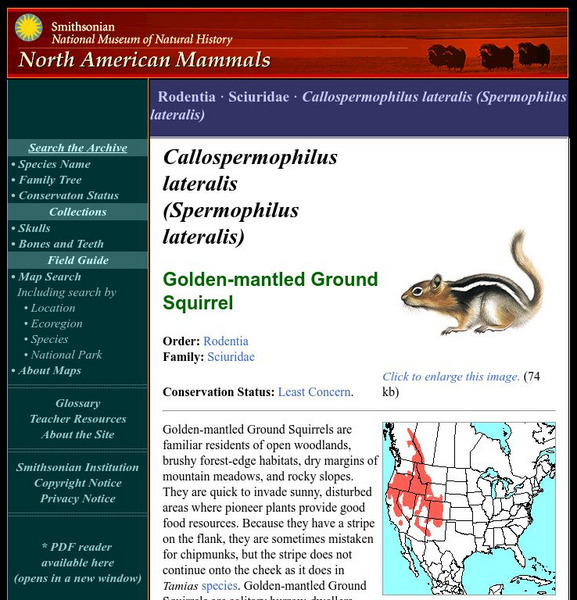
National Museum of Natural History: American Mammals: Golden Mantled Ground Squirrel
Golden-mantled Ground Squirrels are familiar residents of open woodlands, brushy forest-edge habitats, dry margins of mountain meadows, and rocky slopes. They are quick to invade sunny, disturbed areas where pioneer plants provide good...
Smithsonian Institution
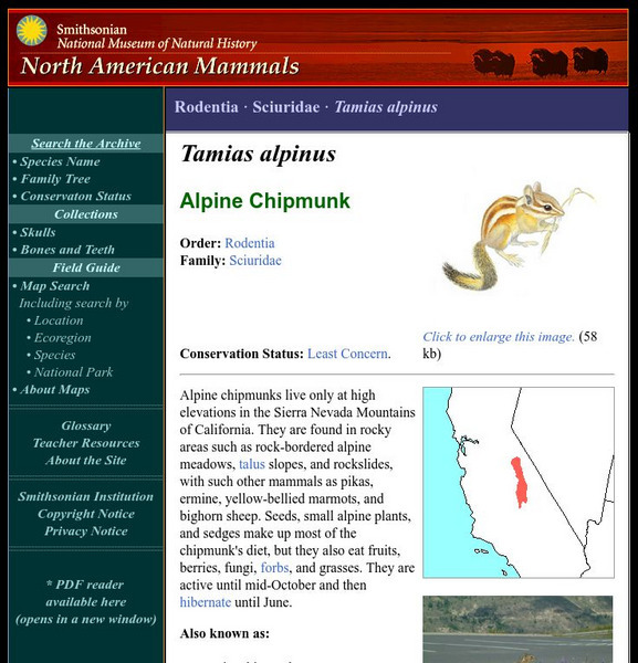
National Museum of Natural History: American Mammals: Alpine Chipmunk
Alpine chipmunks live only at high elevations in the Sierra Nevada Mountains of California. They are found in rocky areas such as rock-bordered alpine meadows, talus slopes, and rockslides, with such other mammals as pikas, ermine,...
Curated OER
Etc: Port Royal (After Champlain), 1603 1639
A facsimile from a map by Samuel Champlain (1613) of the Port Royal basin (Annapolis Royal), Nova Scotia. The map is keyed to show (A) our habitation, (B) Champlain's garden, (C) road made by Poutrincourt, (D) island, (E) entrance, (F)...
Curated OER
Educational Technology Clearinghouse: Maps Etc: Denver Basin, 1911
A geologic map of a section of the Colorado Front Range near Denver and Golden showing the structure and topography of the common border between the Great Plains and Southern Rockies. The map is keyed to show rock types, formations, and...


