University of Georgia
University of Georgia: The United States of North America in 1796
A large map from 1796 of the U.S. States and Territories at the time.
University of Georgia
University of Georgia: A Map of North America (1784)
A large and detailed Dutch map of North America as known to the Europeans in 1784.
University of Georgia
University of Georgia: Hargrett Library Rare Map Collection: Topical War Map of the Southern States
A large detailed map of the central and southern U.S. from 1863. Difficult to read.
University of Georgia
University of Georgia: The Mississippi Territory (1814)
An 1814 American map of the territory of the lower Mississippi valley; part of the larger Louisiana Purchase that President Jefferson purchased from the French in 1803.
Georgia State University
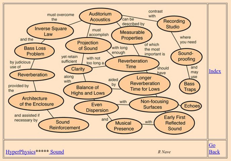
Georgia State University: Hyper Physics: Auditorium Acoustics
Home page for a hypertext physics course on auditorium acoustics and acoustical design.
Georgia State University
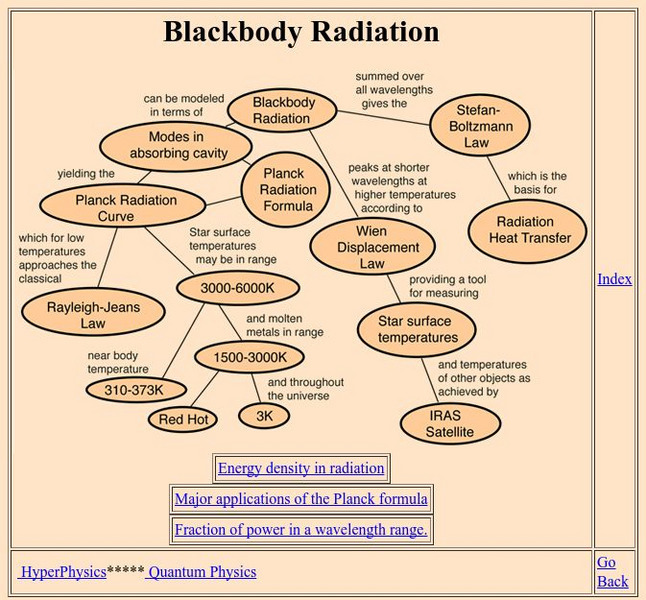
Georgia State University: Hyper Physics: Blackbody Radiation
An indexing page for the HyperPhysics site. This page includes a concept map of links to pages that contain information related to blackbody radiation. Each individual page consists of informative graphics and clear explanations.
Georgia State University
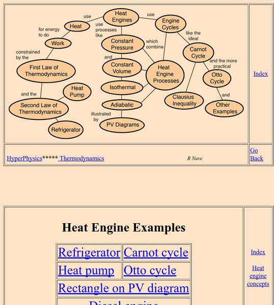
Georgia State University: Hyper Physics: Heat Engine Concepts
An indexing page for the HyperPhysics site. The page contains a concept map of links to a variety of other pages which discuss concepts related to heat engines. All pages contain informative graphics and excellent explanations.
Georgia Department of Education
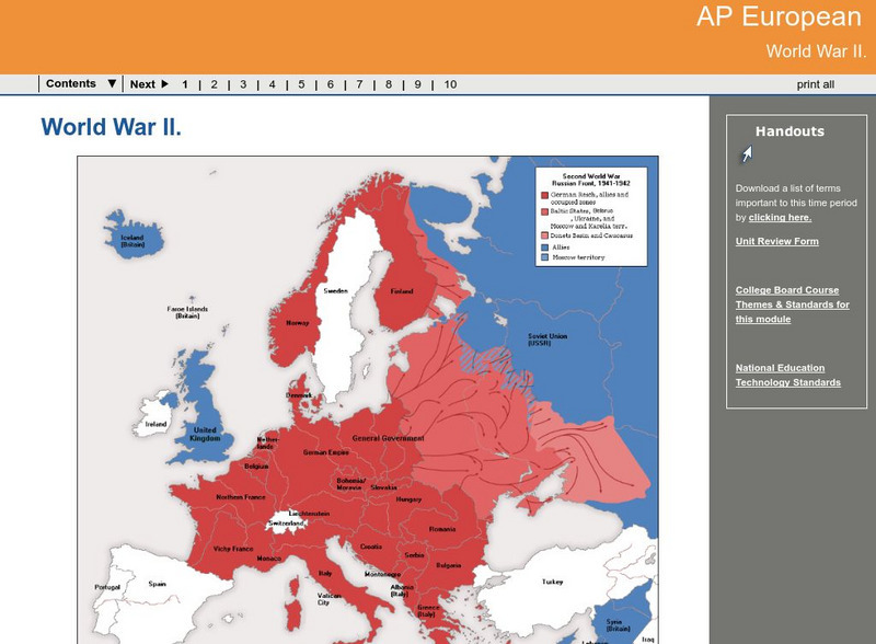
Ga Virtual Learning: Ap European: World War Ii
AP European History learning module on World War II traces the beginnings of the war from a dissillusioned Europe through the course of the war. Module includes assignments, enrichment activities, downloads, maps and assessment for...
Curated OER
Educational Technology Clearinghouse: Maps Etc: Colonial Georgia, 1732 1763
A map of Colonial Georgia, showing the proclamation line of the original United States established at the end of the American Revolutionary War in 1763, the boundary when Georgia was established from the Carolinas as a buffer between the...
Curated OER
Etc: Georgia Claims and Spanish Boundary, 1776 1802
A map of Georgia and Spanish Florida showing the boundaries established and territorial disputes between 1776 and 1802. The map shows the undisputed territory on the Atlantic, the disputed territory by Georgia and the United States...
Curated OER
The u.s. At the Close of the Revolution, Showing Land Claims of States, 1911
A map of the United States at the close of the American Revolution showing the western land claims extending to the Mississippi River by the individual states after the Treaty of 1783 with Britain. The map shows the frontiers with the...
Curated OER
Educational Technology Clearinghouse: Maps Etc: Georgia, 1914
A map from 1914 of Georgia showing the State capital of Atlanta, counties and county seats, major cities and towns, railroads, lakes, rivers, and the Atlantic coastline. A grid reference at the bottom of the map lists counties, principal...
Curated OER
Educational Technology Clearinghouse: Maps Etc: Georgia, 1920
A map from 1920 of Georgia showing the State capital of Atlanta, counties and county seats, major cities and towns, railroads, lakes, rivers, and the Atlantic coastline. A grid reference in the margins of the map lists counties,...
Curated OER
Educational Technology Clearinghouse: Maps Etc: United States, 1789
A map of the United States in 1789, showing the State territorial claims, territories, and areas of territorial dispute. The map is color-coded to show States, territories, British possessions, and Spanish possessions, and shows the...
Curated OER
Educational Technology Clearinghouse: Maps Etc: Georgia, 1912
A map from 1912 of Georgia showing the State capital of Atlanta, counties and county seats, major cities and towns, railroads, lakes, rivers, and the Atlantic coastline. A grid reference in the margins of the map lists counties with...
Curated OER
Educational Technology Clearinghouse: Maps Etc: Georgia, 1902
A map from 1902 of Georgia showing the State capital of Atlanta, major cities and towns, railroads, and rivers.
Curated OER
Educational Technology Clearinghouse: Maps Etc: Georgia, 1906
A map from 1906 of Georgia showing the State capital of Atlanta, major cities and towns, railroads, lakes, rivers, and the Atlantic coastline.
Curated OER
Educational Technology Clearinghouse: Maps Etc: Georgia, 1892
A map from 1892 of Georgia showing the State capital of Atlanta, counties and county seats, major cities and towns, railroads, lakes, and rivers.
Curated OER
Educational Technology Clearinghouse: Maps Etc: Georgia, 1909
A map from 1909 of Georgia showing the State capital of Atlanta, major cities and towns, railroads, northern mountains, lakes, rivers, and the Atlantic coastline.
Curated OER
Educational Technology Clearinghouse: Maps Etc: Georgia, 1919
A map from 1919 of Georgia showing the State capital of Atlanta, major cities and towns, railroads, northern mountains, lakes, rivers, and the Atlantic coastline.
Curated OER
Educational Technology Clearinghouse: Maps Etc: Georgia, 1922
A map from 1922 of Georgia showing the State capital of Atlanta, major cities and towns, railroads, northern mountains, lakes, rivers, and the Atlantic coastline.
Curated OER
Educational Technology Clearinghouse: Maps Etc: Georgia, 1920
A map from 1920 of Georgia showing the State capital of Atlanta, counties and county seats, major cities and towns, railroads, lakes, rivers, and the Atlantic coastline.
Curated OER
Educational Technology Clearinghouse: Maps Etc: Atlanta, Georgia, 1914
A city plan from 1914 detailing Atlanta, showing the city streets and street names, Union train depot and the rail routes, the State Capitol building and Governor's mansion, the Oakland Cemetery, and L. P. Grant Park, and major landmarks.
Curated OER
Educational Technology Clearinghouse: Maps Etc: United States, 1821
A map of the United States and territories in 1821 after the Missouri Compromise, showing the Free States and territories, the Slave States and territories, and the transitional territories at the time. The map is color-coded to show the...


