Lonely Planet
Lonely Planet: Map of Argentina
A basic color map of Argentina is offered at this site, with major cities identified.
University of Georgia
University of Georgia: Hargrett Library: Rare Map Collection
The Hargrett Library at the University of Georgia offers visitors the opportunity to view images of over 800 maps that go back almost 500 years. Researchers get a first-hand look at the lives of early Americans with these original maps...
Houghton Mifflin Harcourt
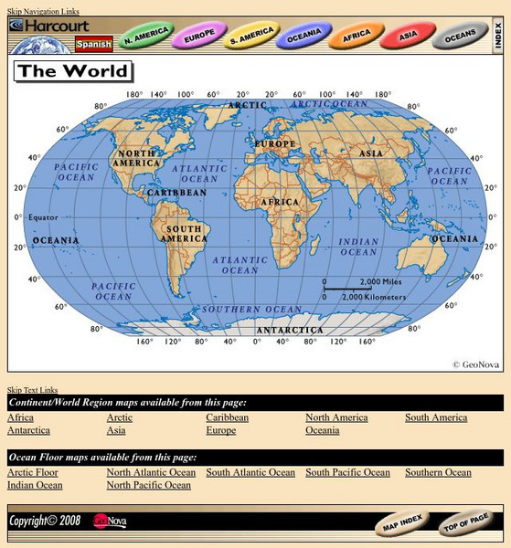
Harcourt: School Publishers: World Atlas: The World
Provides continent, country, and ocean floor maps from all over the world. Click on a continent's name to access the detailed maps which also include statistical facts on each available country.
Other
Ecuador Pictures
A pictorial photo gallery of Ecuador that demonstrates the beauty of this small South American country. View animals, landscapes, towns, monuments, parks, the Rainforest, waterfalls, and so much more.
Houghton Mifflin Harcourt
Holt, Rinehart and Winston: World Atlas: Suriname
View an excellent map of Suriname accompanied by current, detailed information about this interesting country.
Curated OER
Ecuador map.jpg (42166 Bytes)
Comprehensive reference tool with an abundance of country specific information about the South American country of Ecuador. Content covered includes photos, symbols, provinces, history, economy, geography, climate, population, culture,...
Curated OER
Ecuador Map .Gif (35419 Bytes)
Comprehensive reference tool with an abundance of country specific information about the South American country of Ecuador. Content covered includes photos, symbols, provinces, history, economy, geography, climate, population, culture,...
Curated OER
Map of Ecuador
The BBC gives information about the Latin American country of Ecuador with details on geography, culture, its leaders, and its news media. Updated in April, 2005. Check out the link to the timeline.
Curated OER
Perry Castaneda Map Collection: Latin America Map
This political map of Latin America and South America is in color and features major cities.
Curated OER
Ecuador Nature map.gif (10759 Bytes)
Comprehensive reference tool with an abundance of country specific information about the South American country of Ecuador. Content covered includes photos, symbols, provinces, history, economy, geography, climate, population, culture,...
Curated OER
Galapagos Map mc.gif (24108 Bytes)
Comprehensive reference tool with an abundance of country specific information about the South American country of Ecuador. Content covered includes photos, symbols, provinces, history, economy, geography, climate, population, culture,...
Curated OER
M Colombia politico.jpg (271104 Bytes)
Comprehensive reference tool with an abundance of country specific information about the South American country of Colombia. Content covered includes photos, symbols, history, economy, geography, climate, population, culture, maps, and...
Curated OER
Adventure Learning Foundation: Bolivia
Comprehensive reference tool with an abundance of country specific information about the South American country of Bolivia. Content covered includes photos, symbols, provinces, history, economy, geography, climate, population, culture,...
Curated OER
Bolivia departments.png (10876 Bytes)
Comprehensive reference tool with an abundance of country specific information about the South American country of Bolivia. Content covered includes photos, symbols, provinces, history, economy, geography, climate, population, culture,...
Curated OER
Adventure Learning Foundation: Colombia
Comprehensive reference tool with an abundance of country specific information about the South American country of Colombia. Content covered includes photos, symbols, history, economy, geography, climate, population, culture, maps, and...
Curated OER
M Colombia Mapa oficial.jpg (333910 Bytes)
Comprehensive reference tool with an abundance of country specific information about the South American country of Colombia. Content covered includes photos, symbols, history, economy, geography, climate, population, culture, maps, and...
Curated OER
M Colombia politico.jpg (271104 Bytes)
Comprehensive reference tool with an abundance of country specific information about the South American country of Colombia. Content covered includes photos, symbols, history, economy, geography, climate, population, culture, maps, and...
Curated OER
Adventure Learning Foundation: Colombia
Comprehensive reference tool with an abundance of country specific information about the South American country of Colombia. Content covered includes photos, symbols, history, economy, geography, climate, population, culture, maps, and...
Curated OER
Colombia departamentos.png (36451 Bytes)
Comprehensive reference tool with an abundance of country specific information about the South American country of Colombia. Content covered includes photos, symbols, history, economy, geography, climate, population, culture, maps, and...
Curated OER
Ecuador flag.gif (13935 Bytes)
Comprehensive reference tool with an abundance of country specific information about the South American country of Ecuador. Content covered includes photos, symbols, provinces, history, economy, geography, climate, population, culture,...
Curated OER
Ecuador.gif (274368 Bytes)
Comprehensive reference tool with an abundance of country specific information about the South American country of Ecuador. Content covered includes photos, symbols, provinces, history, economy, geography, climate, population, culture,...
Curated OER
Adventure Learning Foundation: Ecuador
Comprehensive reference tool with an abundance of country specific information about the South American country of Ecuador. Content covered includes photos, symbols, provinces, history, economy, geography, climate, population, culture,...
Curated OER
Mapapolitico ecu.jpg (189230 Bytes)
Comprehensive reference tool with an abundance of country specific information about the South American country of Ecuador. Content covered includes photos, symbols, provinces, history, economy, geography, climate, population, culture,...
Curated OER
Adventure Learning Foundation: Brazil
Useful guide with an abundance of country specific information about the South American country of Brazil. Content covered includes photos, symbols, history, economy, geography, climate, population, culture, maps, and lesson plans.


