Curated OER
Educational Technology Clearinghouse: Maps Etc: Oregon Controversy, 1792 1846
A map of the Oregon Territory between the time of exploration by George Vancouver (1792) and the Oregon Treaty of 1846. The map is color-coded to show the disputed claims of the British and United States, the Russian American line of...
Curated OER
Educational Technology Clearinghouse: Maps Etc: Middle Colonies, 1620 1702
A map of the New Jersey Colony between the establishment of the Dutch settlement at Bergen (1620) and the unification of East and West Jersey in 1702. The map shows the 'North River’ (Hudson River) and 'South River’ (Delaware River), the...
Curated OER
Educational Technology Clearinghouse: Maps Etc: Route of De Soto, 1539 1542
A map of the supposed route of Hernando de Soto's expedition taken from Tampa Bay (1539) to the Mississippi River, first reached in 1541, and the site of his death in 1542. The map shows the winter quarters of the expedition in northern...
Curated OER
Educational Technology Clearinghouse: Maps Etc: Mississippi Valley, 1682
A facsimile of a map by Jean Baptiste Louis Franquelin (1682) of the Mississippi River Valley from the Great Lakes to the Gulf of Mexico showing the explorations of Robert LaSalle (Rene-Robert Cavelier, Sieur de la Salle) as far south as...
Curated OER
Educational Technology Clearinghouse: Maps Etc: Battle at the Brandywine, 1777
A map of the area in Pennsylvania south of Philadelphia detailing the Battle of Brandywine during the American Revolution (September 11, 1777). The map shows the battle site of Chad's Ford, the Lancaster Road, the British and American...
Curated OER
Educational Technology Clearinghouse: Maps Etc: Hay Herbert Treaty, 1903
A map of the southern border of Alaska and Canada showing the area of boundary dispute and the boundary established by the Hay-Herbert Treaty between Britain and the United States in 1903. The map shows the coastline and fjords of the...
Curated OER
Etc: Maps Etc: The Thirteen Colonies at the End of the Colonial Period, 1774
A map of the British Thirteen Colonies at the end of the colonial period in 1774. The map shows the boundaries of the colonies and notes the uncolored territory east of the Mississippi and south of the Great Lakes as claimed by Georgia,...
Curated OER
Educational Technology Clearinghouse: Maps Etc: The Carolina Grant, 1665
A map of Georgia and the Carolinas, showing the land granted to eight English lords and gentlemen as joint proprietaries by King Charles II under the charter of 1663, which extended from the southern border of Virginia south to the 29...
Curated OER
Educational Technology Clearinghouse: Maps Etc: Battle of Brandywine, 1777
A battle plan of the Battle of Brandywine in Pennsylvania south of Philadelphia during the American Revolution (September 11, 1777). The American defeat of this battle allowed the British to capture Philadelphia. The map shows the...
Curated OER
Educational Technology Clearinghouse: Maps Etc: The Southern Colonies, 1606
A map of the Southern Colonies showing the current boundaries of Maryland, Delaware, Virginia, North Carolina, South Carolina, and Georgia, showing early European settlements.
Curated OER
Etc: Maps Etc: The War in Northern New York, 1777
A map of the Adirondack Mountains, southern Lake Champlain, eastern Lake Ontario, and Hudson River Valley south to Peekskill showing the important battle sites of the area during the American Revolutionary War.
Curated OER
Etc: Maps Etc: Proposed Division of Western Lands, 1784
A map of the United States and the Northwest Territory east of the Mississippi River showing the proposed division of western lands 'ceded or to be ceded’ by the states according to the Ordinance of April 23, 1784. Under this proposed...
Curated OER
Chile Arg map.jpg (70404 Bytes)
Take an exciting exploration of South America, driving northward along the Andes, crossing back and forth between Chile, Argentina, Bolivia, and Peru. Explore the natural environment, culture, and people. It includes journals,...
Other
Grand Canyon Explorer: Continental Drift
Maps and detailed descriptions of the breakup of Pangea due to a great rift opening.
ClassFlow
Class Flow: Continents of the World
[Free Registration/Login Required] This flipchart is devoted to identifying, locating, and learning facts about the 7 continents. It contains interactive maps, facts, and a short video at the end.
Other
Kids World Travel Guide: Argentina
Here are some interesting Argentina facts which were chosen and researched by kids, especially for kids. Includes history, maps, geography, attractions, animals, people, language, and food.
A&E Television
History.com: The States
Learn unique facts about each American state. You can also read a more in-depth history of each state, watch videos and play a game about all the states.
PBS
Pbs: El Nino
You can link to the anatomy of El Nino, chasing El Nino, and El Nino's reach. There is a resource page and a search page.
Other
Language Crossing: Geography of Bolivia
Features a brief description of the geography of Bolivia including the Andean highlands and the tropical lowlands.
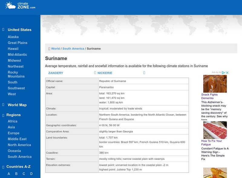
Climate Zone
Climate of Suriname
Explore the climate of Suriname at this useful website that gives information about average temperature, rainfall, and snowfall.
Curated OER
Etc: Reorganization of the Plymouth Company, 1606 1620
A map of eastern North America in 1620 showing the King James Patent of the Plymouth Company to the north and London Company to the south. In 1620, the Plymouth Company was reorganized as the Plymouth Council for New England, or the...
Curated OER
Etc: Early Explorers of the Atlantic Coast, 1492 1620
A map of the Atlantic coast of North America from the Labrador Peninsula and Gulf of St. Lawrence south to the Santee River in the Carolinas, showing the European explorations and settlements in the region between 1492 and 1620. The map...
Curated OER
Map of Paraguay
The BBC provides some quick facts and general information about Paraguay's history, leaders, and media. Links to national anthem and timeline of key events.
A&E Television
History.com: Amerigo Vespucci
Amerigo Vespucci was an Italian-born merchant and explorer who took part in early voyages to the New World on behalf of Spain around the late 15th century. By that time, the Vikings had established settlements in present-day North...


