Curated OER
The River Ran Through It
Students identify the processes that shape our rivers and form our lakes. They participate in hands-on and multimedia activities as they discover and apply the river-cutting processes of water.
Curated OER
Let the River Run
Students explore the environment by reading a story in class. In this water formation lesson, students define environmental terms such as rivers, streams, gulf, oceans and lakes. Students read the story A River Ran Wild and discuss the...
Curated OER
Lesson 7 - Our Rivers and Streams
Students examine the major rivers in Northeast Florida and how they are useful. They study the St. John's River, its tributaries, and unique characteristics.
Curated OER
Growth of a River
Students evaluate geography by drawing an image in class. In this river lesson, students identify a list of vocabulary terms associated with bodies of water. Students identify how a river is formed and draw a picture of one including the...
Curated OER
Questions About Rivers
Young scholars investigate rivers. In this geography lesson, students work in cooperative groups to read about rivers from articles they have collected. Young scholars form questions using Bloom's Taxonomy as a guide.
Curated OER
Natural Features
Students identify natural features on a map. In this geography lesson, students identify six physical features and create pictorial definitions for each term. The terms which are listed in this lesson are mountain, hill, island, river,...
Curated OER
Science: Draining the Land - the Mississippi River
Students use topographic maps to identify parts of rivers. In addition, they discover gradient and predict changes in the channels caused by variations in water flow. Other activities include sketching a river model with a new channel...
Curated OER
Rivers... for Kids
Students investigate U.S. geography by exploring it's bodies of water. In this river formation lesson, students identify the reasons rivers are needed in our country by reading assigned text. Students examine a diagram which explains how...
Curated OER
River Study
Students study physical features of a local stream. They study how to identify water features on topographic maps.
Curated OER
Know Your Watershed
Students investigate the importance and the location of their own watershed by visiting and EPA website and also work in groups to create an action plan on how to protect their local watershed.
Curated OER
River Basin to Reservoirs: A Profile of the Kansas Republican River Basin and Reservoirs
Students examine the role the river played in the settlement of towns in the basin. Student groups prepare an oral presentation on Milford Lake, Tuttle Creek Lake or Perry Lake.
Curated OER
Boundaries and People
Students map watersheds to find their boundaries. In this watershed activity students map and then give their "watershed address." Students show the trail from stream, larger stream to oceans. Students describe the...
Curated OER
The Great Water Hunt
Students create a model of the land to water ratio in a large group and search for all the places water is used at their school while on a Great Water Hunt. They identify where water can be found and compare how much of world is covered...
Curated OER
Map of Pennsylvania's Waters
In this labeling bodies of water in Pennsylvania worksheet, learners observe a map outline of the state with water sources and use the word bank of names of creeks, lakes, reservoirs, and rivers to identify them. Students label 21 bodies...
Curated OER
Culmination of Mighty Waters
Third graders investigate the concept of bodies of water. The information is obtained from the internet while conducting research. Then students draw upon prior knowledge from a film to combine information for the purpose of creating a...
Michigan Sea Grant
Exploring Watersheds
Collaboratively, students partake in a hands-on activity in which they build models of a watershed. Each group member draws an elevation map—a bird's eye view—of their model and predicts how water will flow from the high to low points....
Curated OER
Natural Features
Students identify natural features on a map. In this map skill lesson, students use a landscape picture map to identify mountains, hills, islands, lakes, and rivers. Students use post-it notes to demonstrate their location.
Curated OER
Asia Crossword
In this geography worksheet, students complete a crossword puzzle on the continent of Asia. They answer 21 questions related to the type of government systems found, capital cities, deepest lake, and lowest population density.
Curated OER
Water Table
Students study the meaning of a water table and how it contributes to the existence of streams, swamps, and lakes in Nebraska. They conduct an experiment and complete a diagram of the hydrologic cycle.
Curated OER
What's In A Name? British Surnames Derived from Places
Students study how British surnames were derived from locations. They observe that some of the more common names are still prevalent today.
Curated OER
Any Day Can Be Earth Day
You can make the spirit of Earth Day last year round with these long-term projects.
Curated OER
Soil Runoff Challenge
Students find ways to decrease soil runoff for an African Village as a part of a Peace Corps project. In this soil runoff lesson, students play a soil runoff challenge online. Students complete online activities and view a slide show to...
Curated OER
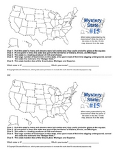
Mystery State #15
Do you know the name of the Badger State? Using five fantastic clues, your super sleuths will determine the name of mystery state number 15. A wonderful way to warm up the class!
Curated OER
WebQuest: Water, Sanitation & Health
Learners examine water issues in Africa. In this global issues lesson, students complete a webquest that requires them gather information. Learners use the information to prepare for a World Water Summit simulation.
