Curated OER
Where in the World? The Basics of Latitude and Longitude
Students are introduced to the concepts of latitude and longitude. In groups, they identify the Earth's magnetic field and the disadvantages of using compasses for navigation. They identify the major lines of latitude and longitude on a...
Curated OER
Precalculus Test
In this precalculus worksheet, students show their mastery of terminal side angles, conversion form degrees to radians and supplementary angles. There are 16 questions on this test.
Curated OER
Sixth Grade Word Problems
In this word problem worksheet, 6th graders problems using given information and mathematical equations. Students solve for 19 problems showing work as needed.
Curated OER
Where am I Located
Learners calculate and find a certain location. In this geometry lesson plan, students examine a coordinate plane for pair of coordinates. They calculate the distance between point using the distance formula and estimation.
Curated OER
Understanding Angles
In this geometry worksheet, students identify the different measure of each angle. They rotate the rays around and make observations about the angles formed. There are 15 questions and lots of examples.
Curated OER
Smack Dab in the Middle
Students read the story Smack Dab in the Middle and complete activities such as charting, writing, illustrating, graphing, and more. In this Smack Dab in the Middle lesson plan, students also discuss the book and retell the story.
Curated OER
The Coordinate Plane
Fifth graders use the attached worksheet, Where's My Location? - Directions, to play a game in which they plot points on a grid.
Curated OER
Mean and Median
Students define mean and median. In this "average" lesson, students calculate the mean and median for a list of given numbers.
Curated OER
Reflections
Students investigate the concept of reflectons. They investigate how an image has a reflection that is symmetrical. They also choose household objects in order to have real life application for finding lines of symmetry.
Curated OER
Graphing on a Coordinate Plane
Eighth graders explore the coordinate system. They identify the x and y-axis, parts of the coordinate plane, and discuss the process of plotting points. To emphasize the process of plotting points, 8th graders play an ordered pair...
Curated OER
Determining the Effectiveness of Handwashing
Students participate in an experiment in which they grow bacterial colonies. They examine the effects of antibiotics killing the germs. They discuss their findings to end the lesson.
Curated OER
Understanding and Computing Riemann Sums
In this Riemann sum worksheet, students use the Riemann sum to determine the volume of a square pyramid and the estimates of area around a circle. This four-page worksheet contains 18 problems.
Curated OER
Anza and Font in Search of Latitude
This is an integrated activity that incorporates Social Studies, Science, and Mathematics. In Social Studies, 7th graders complete an online interview and complete an online worksheet about latitude of sites on the Anza trail. In Science...
Curated OER
Constructing Tangrams
Seventh graders visualize and identify geometric shapes after applying transformations on a coordinate plane. In this tangrams lesson, 7th graders construct a set of tangrams and then answer extension questions related to measurement,...
Curated OER
Locating Points Using Cartesian Coordinates
Students discover coordinates as they explore Chicago. For this math lesson plan, students give the coordinates of a point, plot a point, and use the coordinate system in locating places on a map.
Curated OER
Geo Jammin' By DeSign - Day 1, Lesson 1: Math in Motion
Second graders, through large screen monitor, study geometric design. They participate in a diagnostic assessment in which they use pnecils, scissors and paste.
Curated OER
Finding Slope of a Line
Students calculate the slope of a line. In this algebra activity, students graph a line using the slope and y-intercepts. They define the steepness of the line using the slope.
Curated OER
Latitude and Longitude: Geography and Geometry!
Second graders use latitude and longitude coordinates to pinpoint an exact location on the map. For this geography lesson, 2nd graders utilize handouts from the Maritime Museum in order to gain practice in finding locations throughout...
Curated OER
Coordinate Graphs
Students use coordinate graphs in order to identify objects and their locations. They are shown how to plot the x and y coordinates and then are given values to be plotted during guided and independent practice. Students are assessed on...
Curated OER
Fishing for Points TI-83/83 Plus
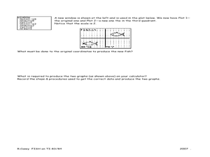
Ninth graders investigate the Cartesian coordinate plane. In this Algebra I instructional activity, 9th graders explore the coordinates of a drawing of a fish and examine the effects of moving the drawing on the ordered pairs....
Curated OER
Can you Find the Expression
Pupils collect data from measurements and weights for this experiment. In this algebra lesson, students analyze graphs they create form their data to find the expression representing the data. They label which graph provided the best...
Curated OER
Word Problems
Students solve word problems using mathematical symbols. In this algebra lesson, students collect data and analyze it. They analyze the data using a table or graph after plotting the data.
Curated OER
Cartesian Baseball
Students are told what a coordinate system is and also that it provides a way of uniquely describing each point on a plane or in space. They are given a practice problem along with the equation. Students solve the following problem:...
Curated OER
Data-gathering Activities Relating to Trees in Their Environment
Students gather data relating to trees in their environment. In this biology lesson plan, students determine heights of trees and their ages. A canopy map will indicate optimal growing areas for the tree.


