Hi, what do you want to do?
Lizard Point Quizzes
Lizard Point: World Oceans and Continents Quiz
Test your geography knowledge by taking this interactive quiz over the world's continents and oceans.
Rice University
Rice University: Ocean Currents and Tides
This URL will start you out at the site map for Rice University's study of longitude and navigation. Scroll to the section titled "Oceans" and you will find some very good information on surface currents, especially those of the South...
SMART Technologies
Smart: Final Project Map Skills
This lessons explores the different ways we can view our world along with the different parts of a map or globe.
TED Talks
Ted: Ted Ed: On Exploring the Oceans
Ocean explorer Robert Ballard takes us on a mindbending trip to hidden worlds underwater, where he and other researchers are finding unexpected life, resources, and even new mountains. He makes a case for serious exploration and mapping....
Australian Broadcasting Corporation
Australian Broadcasting Corporation: Oceans Alive: Whale Dreams
You can click on whale spotting in Australia, types of whales, global whale sanctuary and whale songs. View maps and diagrams that can help you spot whales.
Google
Google Maps: Great Barrier Reef, Australia
With these vibrant and stunning photos, you don't have to be a scuba diver-or even know how to swim-to explore and experience the Great Barrier Reef.
Digital Dialects
Digital Dialects: Geography Games: Oceans and Seas
Study a labeled world map showing the oceans and seas, and then try to match their names to their locations on a blank map.
Other
Monroe County Women's Disability Network: Maps & Globes: Water Forms
This site is provided for by the Monroe County Women's Disability Network. Some basic information about water on our planet and the various water forms that make up three-quarters of the earth's surface. Includes some simple quizzes to...
National Center for Ecological Analysis and Synthesis, University of California Santa Barbara
University of California: A Global Map of Human Impacts to Marine Ecosystems
Maps in different categories such as fishing, climate change, and pollution were pulled together into a composite map that shows the impact of humans on the world's oceans. Analysis at the time (2008) showed that 40% of the world's...
Other
Climate Central: Surging Seas
An interactive map that shows how areas will be effective by rising sea levels. See the flooding risks down to the neighborhood. Also find statistics of affected populations, homes and lands. There is also factsheets, widgets, and action...
A&E Television
History.com: Why the Construction of the Panama Canal Was So Difficult and Deadly
A staggering 25,000 workers lost their lives. And artificial limb makers clamored for contracts with the canal builders. In a quest to fulfill a centuries-old dream to connect the Atlantic and Pacific Oceans, the builders of the Panama...
Columbia University
Scientific Background on the Indian Ocean Earthquake and Tsunami
This site features information and related links that can be used by students and scientists to understand the events that led to the December 2004 Indian Ocean tsunami.
Smithsonian Institution
Smithsonian Education: Tomorrow's Forecast: Oceans and Weather [Pdf]
A lesson unit for Grades 4-9 on how the ocean affects climate and weather. Includes worksheets (also in Spanish) and maps.
Museum of Science
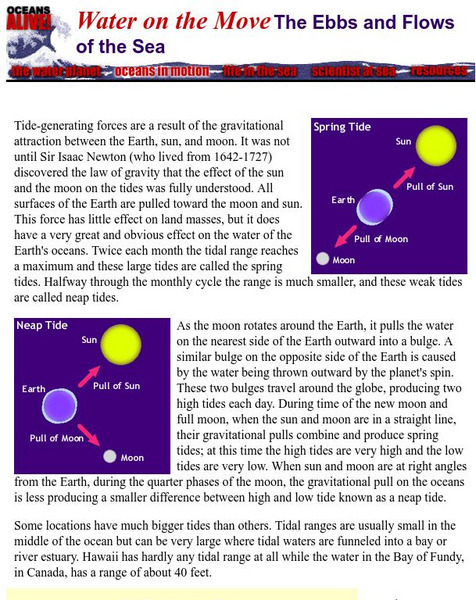
Museum of Science, Boston: Ebbs and Flows of the Sea
A simple one-page explanation of oceanic tides. Includes instructions for completing a tide-mapping activity.
ClassFlow
Class Flow: Maps and Globes
[Free Registration/Login Required] This flipchart reviews map and globe features. The seven continents, four oceans, and city-county-state-country relationships are also explained. Student assessment on directions is included.
Encyclopedia of Earth
Encyclopedia of Earth: British Indian Ocean Territory (United Kingdom)
Provides an overview of British Indian Ocean Territory (United Kingdom), including its geography, natural resources, history, government, economy, and much more. Maps and images are also included, along with sources used to create the...
NOAA
Noaa: Pmel: The North Pacific Ocean
This site includes a map of the North Pacific Ocean, links to the surrounding islands, the ocean currents, and more about the North Pacific.
Other
National Library of Australia: South Seas: Captain Cook
South Seas is an online reference guide to Captain James Cook's momentous first Pacific voyage of discovery (1768-1771). As well as providing the full text of Cook's journal and other important contemporary accounts of the voyage, it...
NOAA
Noaa: Ngdc: Images, Visualizing Data
The National Geophysical Data Center has transformed extensive ocean research into colorful video, 3D maps, charts posters and more! This site starts off with a film clip of a dive into the Marianas trench and then lead you to other...
NOAA
Noaa: Pacific Marine Environmental Laboratory: North Pacific Ocean
This site shows a map of the North Pacific Ocean and the surrounding seas. You can study the islands, or the ocean currents in detail.
Curated OER
Etc: Maps Etc: Physical Features of Europe, 1901
A map from 1901 of Europe, showing the physical features of the region. This map is color-coded to show general elevations from sea level to over 6,500 feet, mountain systems, drainage divides, lakes, rivers, coastal features, and the...
Curated OER
Educational Technology Clearinghouse: Maps Etc: Philippine Islands, 1911
A map from 1911 of the Philippine Islands, showing the major islands, cities, coastal features, and surrounding seas. The map shows the railway from Manila to Dagupan on the Lingayen Gulf (Luzon).
Curated OER
Educational Technology Clearinghouse: Maps Etc: Landforms of Asia, 1904
An outline map from 1904 of Asia showing mountain systems, plateau, plains, major lakes, rivers, coastal features, and seas of the region. This map is used as a key map for locating landform features on a traditional relief map, where...
Curated OER
Educational Technology Clearinghouse: Maps Etc: Kamchatka Peninsula, 1903
A map from 1903 of the Kamchatka Peninsula in the Russian Far East. The map shows cities, towns and ports, terrain, rivers, coastal features, and surrounding seas of the peninsula.


