Curated OER
North, South, East. or West?
In this cardinal directions practice worksheet, students find the places mentioned in 10 statements on a map of the United Kingdom. Students apply their map reading skills to identify each statement as true or false.
Curated OER
Telling Direction - Compass Rose
Keep it simple when practicing directions using this compass rose labeling worksheet. Learners read a brief text describing the cardinal and intermediate directions, then fill in the compass themselves. They can get immediate feedback...
Curated OER
Globe Lesson 3 - Cardinal Directions - Grade 6+
In this cardinal directions worksheet, students read a 2-page review of cardinal directions and use a globe to respond to 5 questions.
Curated OER
Geography Crossword Puzzle
In this history learning exercise, students answer nine questions concerning a variety of states and compass directions including north, south, east and west. Students complete a crossword puzzle.
Super Teacher Worksheets
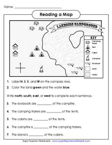
Reading a Map
Young geographers improve their map skills by practicing locating the cardinal directions on a map, identifying symbols on a map key, and describing where objects on the map are located relative to other locations.
Curated OER
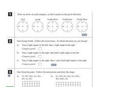
Compass Directions
In this compass activity, students solve 10 problems pertaining to compass directions. Students draw arrows on compasses according to the directions. Students also plot paths on grid paper, following directions given. This page is...
Curated OER
North Or Northern?
In this direction words worksheet, students complete a ten question multiple choice on-line interactive quiz about the correct use of direction words such as north, northern, east, eastern.
Curated OER
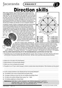
Direction Skills
In this geography worksheet, students read an excerpt on what directions tell someone. They respond to 6 short answer questions related to the neighborhood illustration found on the second page of the worksheet.
Curated OER
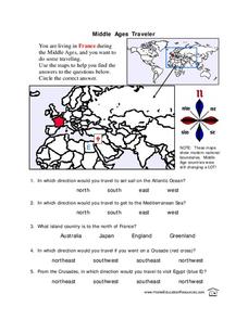
Middle Ages Traveler
In these Middle Ages worksheets, students use the maps to help them find the answers to the questions that help them understand the directions of north, south, east and west. Students also color another map of France according the...
Curated OER
Reviewing Azimuth
Combine angles and the compass rose in this labelling worksheet. Geographers begin by labeling the cardinal directions on a compass template, along with the degrees corresponding to each. They then add the azimuthal directions, labeling...
Curated OER
Primary Directions Activity
In this primary direction worksheet, students fill in directions shown by arrows: north, south, east or west. A reference web site for additional activities is given.
Random House
Mapping Skills
Spark interest and enhance your pupils' map skills using Matteo Pericoli's book, See the City: the Journey of Manhattan Unfurled. Through Pericoli's illustrations and text, learners explore the East and West...
Curated OER
Writing Vectors
In this vectors worksheet, students draw 15 vectors using a given key with direction and measurement. Students are given a specific distance and direction for each vector to draw.
Curated OER
North Dakota Reading Comprehension
In this North Dakota reading comprehension worksheet, students read a 2-page selection regarding the state and then respond to 10 true or false questions.
Curated OER
All About the Animals
Whose footprints are those? After reading Janet Halfmann's book, Little Skink's Tail, young scholars use footprints to determine where on a gridded map certain animals have been spotted. They use the map to answer 3 questions, one...
Curated OER
Map Reading
In this reading maps practice worksheet, students respond to 16 questions that require them to determine the directions north,, south, east, and, west.
Curated OER
A Walk in Winchester
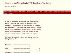
In this Winchester worksheet, students determine the number of different routes to a determined location. This one-page worksheet contains 1 problem. The answer is provided at the bottom of the page.
K12 Reader
Where On Earth Are You?
What do we use to determine the exact locations on the earth? Your kids can learn all about compass roses and latitude and longitude. Test understanding with the five reading comprehension questions included on the page.
Richmond Community Schools
Map Skills
Young geographers will need to use a variety of map skills to complete the tasks required on this worksheet. Examples of activities include using references to label a map of Mexico, identify Canadian territories and European...
Curated OER
Total English: Activity 3
In this ELL activity, students write sentences about given cities and determine whether they are south, east, north, west or centre of their countries. Students then complete a word search on nationalities.
Curated OER
Determining Direction With A Map- Online Interactive
In this map skills worksheet, students analyze a city map and study the compass rose. Students answer 10 questions about the map. This is an online interactive worksheet.
Curated OER
South Dakota
In this South Dakota worksheet, students read 9 short paragraphs about the early settlement and statehood of South Dakota. Worksheet has no other associated activities.
Curated OER
Latitude Longitude
In this latitude and longitude activity, students plot 39 latitude/longitude locations on a graph, connecting the dots as they go along.
Curated OER
Latitude Longitude
In this latitude and longitude worksheet, students plot 34 latitude/longitude locations onto a graph, connecting the dots as they go along.


