Hi, what do you want to do?
NASA
Nasa: World Map Puzzle
This site from the National Aeornautics and Space Administration provides an interesting activity with a relief map and its correlation with space. "Wouldn't it be fun to make your own miniature world, complete with mountains, valleys,...
Other
Jean Craighead George's Website
This website is about author Jean Craighead George. Offers information on her background, her books, she gives hints about becoming a writer. She also has a question and answer section where she answers questions that people most often...
Library of Congress
Loc: Earth as Art: A Landsat Perspective
A really cool site showing Satellite (Landsat 7) images of unique geographical and meteorological phenomena. Images show cloud formations to rainforest devastation.
eSchool Today
E School Today: Landforms
Understand the formation and geology of different landforms around the Earth.
Other
Ecuador 365
Enjoy a photographic journey through Ecuador in all seasons. You can travel from the jungle - full of exotic plants and animals - to the highlands with their immense snow-covered and still active volcanoes- all these you can see in...
Art Institute of Chicago
Art Institute of Chicago: Art Access: American Art to 1900
Study works of American art from the eighteen and nineteenth centuries. Works in a variety of media, including the decorative arts, are represented as are pieces by some of America's best-known artists: Copley, Church, Homer, and...
ClassFlow
Class Flow: Plate Tectonics Intro
[Free Registration/Login Required] This flipchart will take several class periods. This lesson begins to look at how the different landforms are created. There will be two follow up lessons - one on volcanoes and one on mountains.
Curated OER
Etc: Maps Etc: Mexico, Central America, and the West Indies, 1898
A map from 1898 of Mexico, Central America and the West Indies. The map includes an inset map of Cuba and the Isthmus of Nicaragua. "The surface of the Rocky Mountain highland in Mexico is quite similar to that of the great plateau...
University of Colorado
University of Colorado: Ph Et Interactive Simulations: Plate Tectonics
Explore how plates move on the surface of the earth. Change temperature, composition, and thickness of plates. Discover how to create new mountains, volcanoes, or oceans! Java is required.
Curated OER
Etc: Maps Etc: Physical Map of South America, 1898
A map from 1898 of South America showing the general physical features including mountain systems, prominent peaks and volcanoes, river and lake systems, plateaus, and coastal features. The map includes an insert of the Isthmus of...
Curated OER
Etc: Maps Etc: Physical Map of South America, 1916
A map from 1916 of South America showing the general physical features including mountain systems, prominent peaks and volcanoes, river and lake systems, plateaus, and coastal features. The map is color-contoured with land elevations...
Curated OER
Etc: Maps Etc: Physical Map of South America, 1901
A map from 1901 of South America showing the general physical features including mountain systems, prominent peaks and volcanoes, river and lake systems, plateaus, and coastal features. The map is color-coded with the highlands above...
Curated OER
Etc: Maps Etc: Physical Map of South America, 1902
A map from 1902 of South America showing the general physical features including mountain systems, prominent peaks and volcanoes, river and lake systems, plateaus, and coastal features. The map is color-coded with the highlands above...
University of Colorado
University of Colorado: Ph Et Interactive Simulations: Ph Et: Interactive Simulations: Plate Tectonics
Students studying plate tectonics will better understand its concepts with this virtual experiment that tests how plates move on the surface of the earth. Temperature, composition, and thickness of plates can be changed to create new...
World Atlas
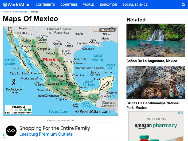
World Atlas: Mexico
Provided here is a description of Mexico's geography including its mountain ranges, coastal plains, plateaus, volcanoes and peninsulas.
Curated OER
Science Kids: Science Images: Mount Elbrus, Russia
This is a beautiful photo of Mount Elbrus, the tallest mountain in Russia and all of Europe. The snow dusted mountain is an inactive volcano which has had no recorded eruptions. Mount Elbrus is 5642 metres (18510 feet) in height. For...
Curated OER
Educational Technology Clearinghouse: Maps Etc: North America, 1868
A map from 1868 of North America, Central America, and the Caribbean showing the physical features of the region, vegetation types, ocean currents, temperatures, principal products and mineral deposits. Mountain chains are represented by...
Curated OER
Educational Technology Clearinghouse: Maps Etc: South America (Physical), 1901
A map from 1901 of South America showing the physical features of the region. This map is color-coded to show general elevations from sea level to over 6,500 feet, mountain systems, drainage divides, lakes, rivers, coastal features, and...
Curated OER
Educational Technology Clearinghouse: Maps Etc: South America (Physical), 1868
A map from 1868 of South America showing the physical features of the region, vegetation types, ocean currents, temperatures, principal products and mineral deposits. Mountain chains are represented by lines of varying thickness, with...
Curated OER
Educational Technology Clearinghouse: Maps Etc: Asia (Physical), 1868
A map from 1868 of Asia showing physical features and natural resources of the region. The map shows political boundaries of the time, with capitals, major cities, and ports. The map shows mountain systems with black lines of variable...
Curated OER
Educational Technology Clearinghouse: Maps Etc: Europe (Physical), 1868
A map from 1868 of Europe, showing the physical features, climate, and commercial resources of the region. Mountain chains are represented by lines of varying thickness, with the broader the line, the greater the elevation. The highest...
Curated OER
Educational Technology Clearinghouse: Maps Etc: Manila, 1919
A map from 1919 of the area around Manila, Philippines, from Manila bay in the north to Semirara Island in the south. The map shows the numerous islands, mountains (volcanoes), cities, and coastal features in the area, including Mindoro...
Curated OER
Etc: Maps Etc: Physical Map of South America, 1910
A physical map from 1910 of South America showing color-contoured land elevations and water depths. Elevations range from sea level to over 6,500 feet, and water depths range from sea level to below 13,000 feet. This map shows the...
Curated OER
Etc: Maps Etc: Physical Features of Europe, 1901
A map from 1901 of Europe, showing the physical features of the region. This map is color-coded to show general elevations from sea level to over 6,500 feet, mountain systems, drainage divides, lakes, rivers, coastal features, and the...


