AGSSS
World Regions
Help your learners to visualize where historical events have taken place around the globe with a map that details the major regions of the seven continents.
Curated OER
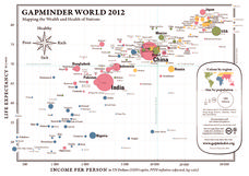
Gapminder World 2012
Here is a very interesting infographic that compares the average life expectancies, per capita incomes, and population sizes of every country in the world in 2012.
NASA
Outline Maps
Don't miss this gold mine of blank maps for your next geography lesson! Regions include traditional continents such as Asia, Europe, and Africa, as well as other major world areas such as the Pacific Rim and the Middle East.
Smithsonian Institution
Dia de los Muertos: Celebrating and Remembering
Help scholars understand the history, geography, traditions, and art of Dia de los Muertos, the Day of the Dead. Find background information for your reference as well as a detailed cross-curricular lesson plan. Learners compare...
Other popular searches
- New Mexico Geography
- Geography of Mexico
- Mexico Geography Map
- Geography Mexico
- Cultural Geography of Mexico
- The Geography of Mexico
- Physical Geography of Mexico
- Teaching Geography of Mexico
- Making Physical Maps Mexico


