University of Texas at Austin
Perry Castaneda Library Map Collection: Mexico Maps
This site provides a wealth of maps relating to the country of Mexico.
Curated OER
Mexico City
Tourist guide for Mexico City with street map and other useful information for visitors.
Curated OER
Mexico City
Tourist guide for Mexico City with street map and other useful information for visitors.
Curated OER
Mexico City
Tourist guide for Mexico City with street map and other useful information for visitors.
Curated OER
Mexico City
Tourist guide for Mexico City with street map and other useful information for visitors.
Curated OER
Unesco: Mexico: Historic Centre of Mexico City and Xochimilco
Built in the 16th century by the Spanish on the ruins of Tenochtitlan, the old Aztec capital, Mexico City is now one of the world's largest and most densely populated cities. It has five Aztec temples, the ruins of which have been...
Curated OER
Educational Technology Clearinghouse: Maps Etc: Mexico City and Vicinity, 1580
A facsimile of a map by Saverio Clavigero (1780) of Tenochtitlan (Mexico City) and vicinity around the time of the Spanish conquest in 1519. This map, according to William H. Prescott (History of the Conquest of Mexico, 1876), defies...
Houghton Mifflin Harcourt
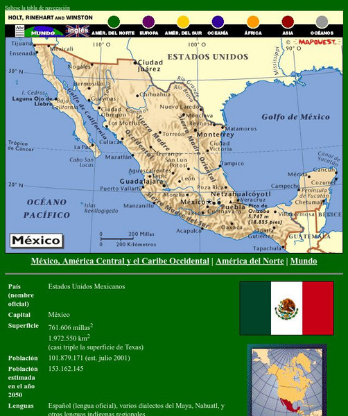
Holt, Rinehart and Winston: America Del Norte: Mexico
This site has a map of Mexico in Spanish, with informational data also presented in Spanish about the country. Land mass, population, life expectancy, literacy, industry, agriculture, minerals and resources are among the topics...
Geographic
Mexico (Maps)
Maps of Mexico, including one with major cities, and another with the Mexican states.
Curated OER
Castillo De Chapultepec
Pictures, ratings, and brief descriptions of major tourist sites in Mexico City.
Curated OER
Bas Lica De Nuestra Se Ora De Guadalupe
Pictures, ratings, and brief descriptions of major tourist sites in Mexico City.
Mex Connect
Mex connect.com: Map of Michoacan
MexConnect offers a map of Michoacan that shows the locations of the major cities located within.
Curated OER
Etc: Maps Etc: City of Mexico and Suburban Towns, 1899
"The city [Mexico City] is in what is called the Federal District, covering an area of some four hundred and fifty square miles - the government of the district like the District of Columbia is directed, by the national legislature,...
Curated OER
Etc: Vicinity of the City of Mexico, 1846 1848
A map of the area around Mexico City showing important sites of General Scott's campaign in the Mexican&ndash:American War (1846-1848). The map shows Lake Joltoca, Lake Cristobal, Lake Tezuco, Lake Xochimilco, and Lake Chalco, and...
Curated OER
Unesco: Mexico: Pre Hispanic City of Teotihuacan
The holy city of Teotihuacan ('the place where the gods were created') is situated some 50 km north-east of Mexico City. Built between the 1st and 7th centuries A.D., it is characterized by the vast size of its monuments - in particular,...
Curated OER
Etc: Maps Etc: Political Divisions of Mexico, 1916
A map from 1916 of Mexico showing the political divisions of states and territories (Quinana Roo on the Yucatan Peninsula, Tepic on the Gulf of California, and Baja California) at the time, including the state capitals and the Federal...
Curated OER
Educational Technology Clearinghouse: Maps Etc: Vicinity of Mexico, 1847
A map of the vicinity of Mexico City showing the route of General Scott from Puebla to the city during the Mexican-American War (1847), including operations and battle sites in the area.
Curated OER
Educational Technology Clearinghouse: Maps Etc: Northeast Mexico, 1846 1848
A map of eastern Mexico along the Gulf showing important battle sites during the Mexican-American War (1846-1848), including Matamoros, Monterey, and Buena Vista during the Taylor campaign, and Vera Cruz and Mexico City during the Scott...
Curated OER
Educational Technology Clearinghouse: Maps Etc: Cortes in Mexico, 1519
A map showing the expedition of Hernan Cortes in 1519. This expedition was the third to the mainland and took him all the way into Mexico. This map shows the route from the Battle of Cintla (Tabasco) to Veracruz (Villa Rica de la Vera...
Curated OER
Educational Technology Clearinghouse: Maps Etc: Cortes' March to Mexico, 1519
A map of Mexico showing the sites of the Spanish Conquistador expedition under Hernan Cortes in 1519. The map shows Juanna (Cuba), Tabasco, Vera Cruz, and Mexico City (Tenochtitlan). An inset map details the route taken by Cortez from...
Curated OER
National Museum of Anthropology, Mexico City
There are two exhibitions available online: Formative Mesoamerico and Teotihuacan. Both exhibits have pictures and narratives.
Other popular searches
- Mexico City and Countryside
- Mexico City Map
- Population Mexico City
- Pollution in Mexico City
- Mexico City Class Projects
- Mexico City Earthquake
- Mexico City Bus Tour
- Environment Mexico City
- Mexico City and Pollution
- Mexico City Air Pollution
- Mexico City Air Polution


