Curated OER
Geographical Skills-- Map Scale
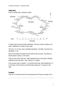
In this maps learning exercise, students study a simple map and the scale in kilometres. Students read the directions and answer one question. Students then look at a sketch map of a town and answer 2 questions. Students also read how to...
Curated OER
Scale Skills
In this mapping skills worksheet, students read an excerpt that describes three different types of scales and how to calculate distance on a map. They respond to two short answer questions using the map provided on the sheet and to...
Curated OER
Map Work: How Far?
In this map scale activity, students analyze a map of an area with several towns marked. Students use the scale (1 cm = 1 km) to answer 6 questions about the distances between towns.
Curated OER
Real World Investigation- Math and Geography- Elevation Changes
In this math and geography real world investigation, 6th graders plan a driving trip to a city that is located several states away from their home while recording the elevations of three cities that are included in the trip. They use...
Curated OER
Problem-Solving Decisions: Reasonable Answers
In this problem solving worksheet, students answer 6 questions pertaining to a story problem about a tabletop scale model of the Nile River.
Curated OER
Mapping Skills
For this mapping skills worksheet, students practice scale measurements as they respond to 8 questions that require them to measure to scale.
Curated OER
The Sustainable Olympics
In this sustainable Olympics worksheet, students utilize a large map of the British Isles, map scale a long piece of string to calculate the approximate distance between their school and 8 locations where some of the Olympic events may...
Curated OER
Make a Map
In this mapping activity worksheet, learners finish the map by following the 5 directions and using the map key. Students the map key, scale, and an inch ruler for help.
Curated OER
Tooling Around Arizona: Measuring Distances
In this measurement worksheet, student measure the distances between Arizona cities by using a the scale on an Arizona Cities map. Students complete 15 problems.
Curated OER
Diagon Alley in Toronto
In this Harry Potter instructional activity, students draw a diagram of Toronto's wizarding quarter. Students make the map as colorful and accurate as possible.
Other popular searches
- Map Scale Math Lessons
- Math Map Scales
- Map Scale Math Skills
- Math Map Scales Problems
- Math Scale Map
- Scale Math and Map Reading


