Curated OER
Virtual Field Trip
Are we there yet? Young trip planners learn about their state and plan a trip. They will select sites to see in three cities in their state, and record associated costs in a spreadsheet. While this was originally designed as a...
Curated OER
Around the Town
In the world of GPS, make sure your kids can still read maps and determine distances between locations. You will need neighborhood street maps, ideally of your class' home turf. Ask kids questions about different locations in relation to...
Curated OER
Exploring the Hudson in 1609
While this lesson focuses on a study of the Hudson River, it could be used as a template for a discussion of map skills, converting measurements, and plotting a route. The lesson includes vocabulary and other resources to make it a...
101 Questions
A Cyclist's Marriage Proposal
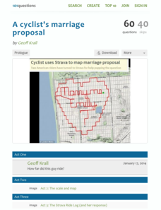
One cyclist goes to great lengths to make his proposal! Your classes must figure out just what length that is. Using a map with a bike route that spells out Marry Me, learners calculate the total distance of the ride. They base their...
Curated OER
Mapping the Transcontinental Journey
Students develop their geography skills. In this Lewis and Clark lesson, students collaborate to calculate the time and distance of different segments of the expedition. Students compare their estimate to Lewis and Clark's.
Curated OER
Exploring Maps: Lesson 2 Guide: Navigation
Young scholars explore and examine how maps have been used in navigation. They research how travelers collected observations to keep track of their positions and plotted information on maps. Each student then makes a Mercator projection...
Curated OER
Introduction to Maps
Students investigate a variety of maps to explain what each one is used for.
Curated OER
The Road Map & the Middle East
Will walls help? Read to learn how Prime Minister Ariel Sharon proposes to build walls around Isreal in hopes of isolation from Palestine. Complete an online Webquest, analyze maps, listen to audio clips, answer discussion questions, and...
Curated OER
Leaf Peeping at Sharpe!
While this lesson focuses on observations made at Sharpe Reservation, another area could be used. Learners map out a route from their class to a nature preserve. Then, they identify the color and features of the leaves, and describe...
Curated OER
Orienteering - Lesson 7 - Compasses
More compass practice! This activity has your scholars practicing getting their bearings. They will participate in a schoolyard compass game where they will have a specific starting point and then navigate through the course according to...
Radford University
Getting Around Millbrook
When is the distance formula not accurate? Referencing a map of the school, pairs determine the walking distance between two locations. Creating coordinates for each location, pupils determine the distance between the two points and...
Curated OER
Maps
In this geography worksheet, 8th graders examine two maps of the slave routes to the West Indies. There are no questions associated with this page.
Curated OER
Map Activity - Roanoke Valley
Students write directions from a starting point to a destination using a map and ads from the Yellow Pages. They define the following terms using total body response or through the use of random objects: "right-hand," "left-hand,"...
Curated OER
Exploring Maps: Navigation
Students engage in a activity that is concerned with the concept of navigation while research is conducted with the use of a variety of resources. The information is used to expand their perspective of the applications for navigation....
Curated OER
U.S. History: de Soto's Alternate Route
Eighth graders examine various maps associated with Hernando de Soto's expedition. By comparing their textbook maps with newer maps, they answer a battery of focus questions. Using Microsoft Word, 8th graders answer the questions...
Curated OER
The Crusades: Routes of Two Crusaders
Use these worksheets to kick off a great lesson on The Crusades. Eighth graders will analyze a map and four short passages to answer six reading comprehension questions.
Curated OER
The Pilgrims
Students use distance measuring tools to follow directions and chart the path the pilgrims made from Plymouth, England to Boston, Massachusetts. In this Pilgrim voyage lesson, students use a map to chart the distance traveled by the...
Curated OER
The Underground Railroad
Young scholars explore the Underground Railroad routes. In this map skills and Civil War instructional activity, students use map and globe reading vocabulary and skills to track the routes the slaves followed from the Bahamas to the...
Curated OER
Lewis & Clark Map
In this Lewis and Clark expedition map worksheet, learners examine the route of the expedition and the separate return routes of both Lewis and Clark.
Curated OER
Lewis & Clark Map
In this Lewis and Clark expedition map activity, students examine the route of the expedition and the separate return routes of both Lewis and Clark.
Curated OER
Trails West: Westward Expansion Maps
In this United States historical map learning exercise, students examine the trails that settlers of the Western United States took during the period of Western Expansion. Major cities on the routes are labeled.
Curated OER
Inspirational Mapping for the Corps of Discovery
Third graders use a computer software entitled, Inspiration, in order to create a map or web of what Lewis and Clark should have packed for their journey west. They are given the expectations of the teacher and a scoring guide is...
Curated OER
Timothy's Trip
In this route worksheet, students draw the route Timothy took on his trip based on the information given. Students draw the route on graph paper where each point equals 4 miles.


