University of Texas at Austin
Ut Library: Perry Castaneda Maps of Oklahoma
A collection of state, city and historical maps of Oklahoma. Also includes maps of national monuments and parks in the state.
University of Texas at Austin
Perry Castaneda Library Map Collection: Venezuela Maps
This site provides several country and city maps as they relate to Venezuela.
University of Texas at Austin
Perry Castaneda Library Map Collection: Maps of u.s. National Parks
Alphabetical list of maps of United States National Parks and monuments produced by the U.S. National Park Service.
University of Texas at Austin
Perry Castaneda Library Map Collection: Historical Maps: Europe, a.d.1560
Detailed map of Europe around A.D. 1560.
Brown University
Brown University Library: Lincolniana at Brown: Lincoln Broadsides
Showcases an extensive collection of advertisements, posters, maps, pamphlets, and other miscellaneous objects that document President Abraham Lincoln's place in American culture.
American-Israeli Cooperative Enterprise
Jewish Virtual Library: Home Page
A fantastic reference or introduction to Jewish history for teachers and students. You'll find information and photos of Jewish women, politics, maps, and much more.
University of Alberta
University of Alberta: The Canadian Northern Railway Maps
This collection of maps details the railway system in Western Canada in 1916. Viewer can zoom in on the maps for added detail.
Harvard University
Harvard University Library: Open Collections: Immigration to the u.s.,1789 1930
Find books, pamphlets, photographs, maps, and manuscripts about immigration to the United States, principally nineteenth-century immigration. With a timeline of key dates in U.S. immigration history and a browsable list of search themes...
University of Texas at Austin
Perry Castaneda Library Map Collection: u.s. Maps
At this site find any type of map on the U.S. and any of its states here. Great site for teachers to print out maps to use in the classroom.
Other
Civics Online: Map of the 13 Colonies
This colorful map depicts the original thirteen colonies as well as the rest of the eastern part of America, showing the owners of the land at that time.
Other
Unh Dimond Library: Historic Usgs Maps of New Hampshire
A site with a very plain map, that contains links to detailed maps of more specific areas in New Hampshire.
Texas State Library and Archives Commission
Texas State Library and Archives Commission: Hard Road to Texas 1836 1845: Lamar and the Rise of Texas Nationalism
The pride Texans feel about their state "can be traced to roots in the Republic of Texas era." Read about this era and the president who wanted Texas to stand alone and not become part of the U.S., and check out a map and other primary...
University of North Carolina
Unc University Libraries: Digital Collections: Gilmer Civil War Map Collection
A large collection of Civil War maps of the south, mostly North Carolina and Virginia. The collection can be searched by state or key word.
The Newberry Library
Newberry Library: Historic Maps in K 12 Classrooms
Great resource for teachers of geography and American history for all levels. You will find lesson plans based on the use of maps for all ages.
The Newberry Library
Newberry Library: Mapping Chicago and the Midwest, 1688 to 1906
Learning resource uses maps to tell the early history of Chicago and the Midwest and explores how nations use maps to secure control of a region.
Library of Congress
Loc: Moby Dick Literary Map
This site is from the American Treasures of the Library of Congress, this site contains information and a link to a "Moby-Dick" literary map titled "The Voyage of the Pequod." The map link provides a full-color image of this historic...
Library of Congress
World Digital Library: Map of Atlantic Coast: Chesapeake Bay to Florida
A historic map of the Atlantic coast of America created by cartographer Joan Vinckeboons around 1639 for the Dutch West India Company. A feature on the page allows the visitor to listen to and read the accompanying descriptive text in...
Library of Congress
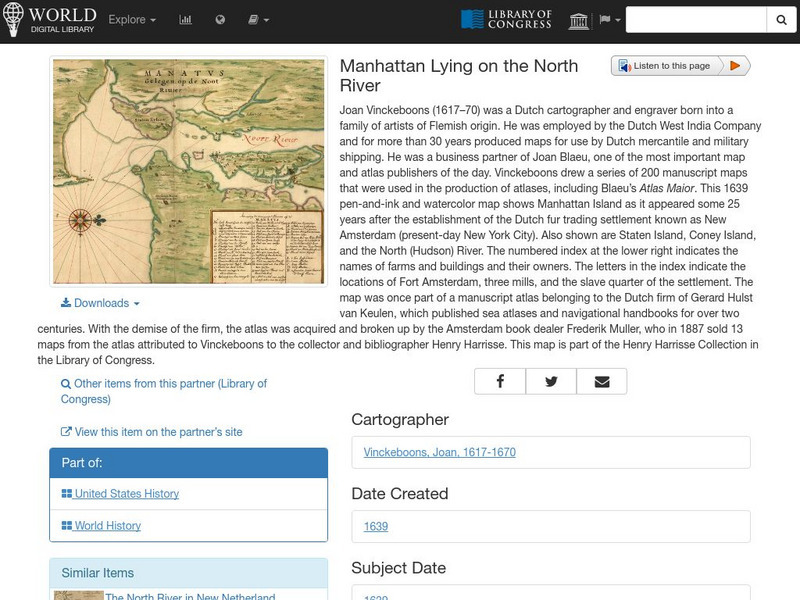
World Digital Library: Manhattan Lying on the North River
A historic map of Manhattan created by cartographer Joan Vinckeboons around 1639 for the Dutch West India Company. A feature on the page allows the visitor to listen to and read the accompanying descriptive text in seven different...
University of Virginia
Lewis and Clark: Maps of Exploration 1507 1814
An online resource from the University of Virginia Library. This exhibition includes maps, documents, and a great overview map collections from the first images of the New World to maps from the Lewis and Clark Expedition.
Other
Early Maps of Newfoundland and Labrador
The Memorial University Libraries presents historical maps of Newfoundland and Labrador. The database of about 380 scanned images contain maps that span over 500 years of history from 1554 to the late 20th century. The database contains...
PBS
Pbs Learning Media: Library of Congress: Media Gallery | Women's Suffrage
This collection of primary source documents from the Library of Congress supports teaching about women's suffrage in the United States. These primary sources include images, song sheets, articles, statistical documents, maps, political...
The Newberry Library
Newberry: Exploration and Encounter: Map 1: The World Columbus Knew in 1482
Newberry Library presents historical map on the Age of Exploration with lesson plans for all ages k-12. Includes curator notes and a wealth of supplemental resource material.
Other
Bowdoin College Library: Joshua Lawrence Chamberlain Digital Archive
Chamberlain's life and legacy. Archive includes examples of letters written by and to Chamberlain, a gallery of photographs, and annotated biographical maps courtesy of Google Earth and Google Maps.
Other
Toronto Public Library: Frozen Ocean: Hudson Bay and the Hudson's Bay Company
Presents historical images and maps of the area that the Hudson's Bay Company controlled.
