Curated OER
Wyoming Outline Map
In this Wyoming outline map worksheet, students examine political boundaries of the state and the placement its capital city as well as its major cities. This map is not labeled.
Curated OER
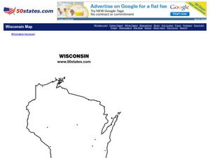
Wisconsin Outline Map
In this Wisconsin outline map instructional activity, students examine political boundaries of the state and the placement its capital city as well as its major cities. This map is not labeled.
Curated OER
West Virginia Outline Map
In this West Virginia outline map worksheet, students examine political boundaries of the state and the placement its capital city as well as its major cities. This map is not labeled.
Curated OER
Utah Outline Map
In this Utah outline map worksheet, students examine political boundaries of the state and the placement its capital city as well as its major cities. This map is not labeled.
Curated OER
Tennessee Outline Map
In this Tennessee outline map worksheet, students examine political boundaries of the state and the placement its capital city as well as its major cities. This map is not labeled.
Curated OER
South Dakota Outline Map
In this South Dakota outline map worksheet, students examine political boundaries of the state and the placement its capital city as well as its major cities. This map is not labeled.
Curated OER
Rhode Island Outline Map
In this Rhode Island outline map activity, students examine political boundaries of the state and the placement its capital city as well as its major cities. This map is not labeled.
Curated OER
Washington Map
In this Washington state outline map worksheet, students examine political boundaries of the state and the placement its capital city as well as its major cities. This map is not labeled.
Curated OER
Bathymetric Mapping
Students draw contour lines based on NOAA soundings on a nautical chart. They color the contours and glue label tags for topographic features. They determine that the floor of the ocean is composed of hills, plains, ridges, trenches,...
Curated OER
Mapping Landforms of South Carolina
Third graders analyze South Carolina maps. In this geography lesson, 3rd graders locate the five land regions in the state are and discuss how the regions are different. Students identify the major bodies of water and analyze how...
Curated OER
Edible State Map
Fourth graders, using a map of a state for reference, make an edible map that shows the major cities in that state. Once the map is shaped, have students place the M&M's where each major city would be. Now this is a lesson I could...
Curated OER
Creating a Map
Learners create a map of their community. In this mapping lesson, students identify various geographical features and the cardinal directions on maps displayed in the classroom. Learners are divided into three groups to create a large...
Curated OER
Mapping Exercise
In this mapping worksheet, students are given data of children exposed to health risks and their geographical location. Students plot each child's home and the risk factors using an (x, y) grid. They answer 2 questions about the...
Curated OER
Using a Concept Definition Map
Students define "natural disaster" by offering examples and charting them to discover what a concept definition map is. Then students create their own maps using the word "city".
Curated OER
Mapping the Library
Learners compare their school library with another library such as: town library, for example, or a virtual library and identify the most important features. Students use their observations to create a map of the school library that can...
Curated OER
Maps Can Help Us
First graders explore the geography of Montana by analyzing geographic maps of the area. In this Native American reservation lesson, 1st graders discuss the similarities and differences between reservations in the state of Montana....
Curated OER
Map Skills: Explorers, Continents, and Oceans
Third graders use a software program to make and label a map of the world. On the map, they locate the seven continents, oceans and the countries of Europe. They also draw the routes of Christopher Columbus, Juan Ponce de Leon and...
Curated OER
World Map Labels
In this geography skills worksheet, students identify the countries and bodies of water labelled on the maps of the world, Africa, Asia, Canada, Europe, the Caribbean, the Middle East, North America, Australia, and South America.
Curated OER
Europe Labeled Map
In this Europe political map worksheet, students examine the national boundaries. The map also highlights each of the nation's capitals with a star. The countries and capital cities in this map are labeled.
Curated OER
South east Asia and the South Pacific: Political: Labeled Map
In this Asia and the South Pacific map worksheet, students examine the boundaries of the nations in this region of the world. Students also note the location of capital cities as they are denoted by stars. This map is labeled.
Curated OER
Central & Southwest Asia: Labeled Map
In this Central and Southwest Asia outline map activity, students examine boundaries of each of the countries in the region. This map is labeled.
Curated OER
United States of America Map: Capitals
In this United States outline map worksheet, students note the political boundaries of the states that are labeled with postal abbreviation codes as well the labeled state capitals.
Curated OER
Ticky Goes to Jr. Map School
First graders sing "We All Live Together," by Greg and Steve. They look at a map and sing the "Soggy Waffle Song" to study about the compass rose. Students write N, E, S, W on the borders of paper that goes under a 100's chart. The...
Curated OER
Canada Outline Map
In this Canada political map instructional activity, students examine the province boundaries of the nation. The province names are labeled on the map.
Other popular searches
- Labeling a Map
- Africa Map Labeling
- Midwest Map Labeling
- Geography Map Labeling
- Labeling a Map Continents
- Labeling Map Parts
- Labeling Parts of Map


