Curated OER
How Are Boundaries Made, Kept, Broken?
Students perform raps and analyze issues among the rich and poor. They explore how countries are labeled as "third world" and "first world." They create a dialectical journal and examine the country of Nigeria through the reading of...
Curated OER
Shapes, Shapes Everywhere!
Sixth graders investigate the geometric concept of shapes. They locate shapes in their immediate environment and label them according to basic shape. The shapes that are found are recorded by the teacher on chart paper and any...
Curated OER
Folktales: Uncle Cricket, the Soothsayer Lesson Ideas
Students read the Nicaraguan folktale, "Uncle Cricket, the Soothsayer," prior to participating in various activities. Among the ideas presented here are completing story maps, analyzing characters, summarizing the plot, writing...
Curated OER
The Music in Us
Students explore the origins of human music. Students watch a video and participate in a variety of activities. They examine evidence, conduct research on he various animals, and create a concept map.
Curated OER
Trade Route By Sea To Asia
Eighth graders study a map and identify the countries of Spain, Portugal, India, China and Thailand. After a class discussion, 8th graders explain the advantages of trading over land and by sea and they explore the men who journeyed to...
Curated OER
Looking After Aston Hall
In this visiting a historical museum instructional activity, students examine a basic map of Aston Hall, a 400 year old building open to the public. Inside each room box, students write hints and rules for visitors to help them behave...
Mathematics Assessment Project
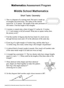
Geometry
Help learners find joy in facing mathematical challenges. The questions posed on this instructional activity encourage young mathematicians to utilize skills learned throughout a geometry unit, and to apply themselves and persevere...
Mathematics Assessment Project
Security Camera
Only you can prevent shoplifting. Class members use a given floor plan to investigate the placement of a security camera. They must incorporate knowledge of area and percents to complete the task.
Curated OER
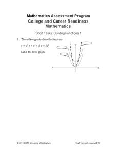
Building Functions
Pupils determine equations that match the graphs of transformations and the parent quadratic function. The resource requires class members to attend to precision and think abstractly.
Mathematics Assessment Project
College and Career Readiness Mathematics Test A1
A six-page test covers content from several different high school math courses. It incorporates a few short answer, graphing, and word problems. It also allows room for mathematical reasoning and analysis.
Curated OER
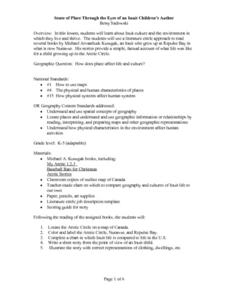
Sense of Place Through the Eyes of an Inuit Children's Author
Students read books by Michael Arvaaluck Kusugak to explore life in the Artic Circle. After reading the books, students compare and contrast life in the Artic Circle to life in the United States. They write and illustrate a story about...
Curated OER
Identify and Construct a Constellation
Third graders identify and construct constellations. For this constellation lesson, 3rd graders choose a method to create a picture of a constellation, either using a shoe box, paper cup, or transparent paper.
Curated OER
Motion
In this motion worksheet, students determine the motion of a ball on different inclined planes, including the velocity and acceleration. This worksheet has 8 problems to solve.
Curated OER
Nevada Trilogy
Learners simulate and plan a trip from St. Louis to the Sacramento Valley as early emigrant parties would have. They list necessary provisions for the amount of time they would spend traveling.
Curated OER
Exploration Resume Project
Seventh graders take on the role of a European explorer and create a resume, or personal data sheet, listing his achievements in reverse chronological order. They draw and label a map and list what the explorer did to add to Europe's...
Curated OER
Using the Four Main Directions in the Classroom
Students use the four main directions to locate features in the classroom. In this direction lesson, students review the 4 main directions using a world map. Students use a magnetic compass to locate the north wall in their classroom and...
Curated OER
Cookie Topography
Students construct a cross section diagram showing elevation changes on a "cookie island." Using a chocolate chip cookie for an island, they locate the highest point in centimeters on the cookie and create a scale in feet. After tracing...
Curated OER
Using 4 main directions in a classroom
Students use the four directions of a compass rose to locate classroom features. In this directions lesson plan, students locate the features by identifying directions.
Curated OER
How Does Blood Circulate?
Fifth graders investigate the path of their blood through their heart and body. In this heart activity, 5th graders recognize that blood travels in one direction through arteries and one through veins. Students complete worksheet...
Physics Classroom
As the Crow Flies Lab
A simple, yet memorable, way of practicing with displacement vectors is described here. Divide your class into groups and assign each a different landmark on campus. They measure smaller legs of the path from the classroom to their...
Curated OER
A World of Information
Students analyze data and statistics about countries around the world. They read graphs and charts, color a world map to illustrate the top ten statistics about the world, and write a paragraph to summarize their information.
Exploratorium
Building Three-Dimensional Structures
Are you looking for a good 3-D geometry lesson that includes hands-on activities for your middle schoolers? Look no further than this one! Pupils use centimeter grid paper embedded in the plan, along with detailed construction...
Curated OER
Cyberspace Safari
Middle schoolers go on an information gathering hunt on the Internet to study West African empires. They work in teams; meteorologists, bankers, writers, and archaeologists. They collect data on all sorts of topics related to West...
Other popular searches
- Labeling a Map
- Africa Map Labeling
- Midwest Map Labeling
- Geography Map Labeling
- Labeling a Map Continents
- Labeling Map Parts
- Labeling Parts of Map


