Curated OER
Maryland State Map
In this map worksheet, students will study a map of the Maryland. Students will use this map to label and/or familiarize themselves with various aspects of the state.
Curated OER
Maine State Map
In this map worksheet, students will study a map of the Maine. Students will use this map to label and/or familiarize themselves with various aspects of the state.
Curated OER
Louisiana State Map
In this map worksheet, students will study a map of the Louisiana. Students will use this map to label and/or familiarize themselves with various aspects of the state.
Curated OER
Kentucky State Map
In this map worksheet, students will study a map of Kentucky. Students will use this map to label and/or familiarize themselves with various aspects of the state.
Curated OER
Washington State Map
For this Washington map worksheet, students color and label the major cities and important physical features on the map. Students also study a second map that shows the location of Washington in the United States.
Curated OER
Antarctica Map
In this Antarctica worksheet, students study a very detailed map of this continent. Important features on this map are labeled.
Curated OER
Idaho State Map
In this Idaho state map activity, students color and label important physical features and cities. Students also study the background map to learn the location of Idaho as related to the rest of the U.S.
Curated OER
Hawaii State Map
In this Hawaii state map learning exercise, students color and label important locations and physical features on the map of the 8 islands of Hawaii.
Curated OER
Massachusetts State Map
In this Massachusetts worksheet, students will study a map of the state. Students will use this map to label and/or familiarize themselves with various aspects of the state.
Curated OER
Pennsylvania State Map
In this geography of Pennsylvania worksheet, learners color and label a map of the state. Students also study the location of Pennsylvania on a grey background map of the entire 50 states.
Curated OER
South Carolina State Map
In this map of South Carolina worksheet, students color and label major cities and physical features in South Carolina. There is also a map showing the location of the state in the U.S.
Curated OER
Utah State Map
For this geography of Utah worksheet, students color and label a map of the state of Utah. Students also study a second map that shows the location of this state in the U.S.
Curated OER
Tennessee State Map
In this Tennessee state geography learning exercise, students color and label major cities and physical features on the map. Students also study a second map of the U.S. that shows the location of the state of Tennessee.
Curated OER
Virginia State Map
In this geography of Virginia worksheet, students color the map and label major cities and physical features. Students also study a second map showing the location of the state of Virginia in the United States.
Curated OER
Delaware State Map
In this geography of Delaware activity, students color the map and label major cities and physical features. Students also study a second map showing the location of the state of Delaware in the United States.
Curated OER
California State Map
In this geography of California worksheet, students color the map and label major cities and physical features. Students also study a second map showing the location of the state of California in the United States.
Curated OER
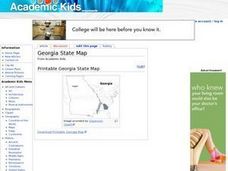
Georgia State Map
In this geography of Georgia learning exercise, students color the map and label major cities and physical features. Students also study a second map showing the location of the state of Georgia in the United States.
Curated OER
Florida State Map
For this geography of Florida worksheet, students color the map and label major cities and physical features. Students also study a second map showing the location of the state of Florida in the United States.
Curated OER
Oregon State Map
In this history worksheet, students view and label a map or Oregon its main regions, major cities, important landmarks, compass rose and a legend.
Curated OER
Oklahoma State Map
In this history instructional activity, students view and label on a state map of Oklahoma its regions, major cities, important landmarks, compass rose and legend.
Curated OER
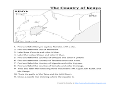
The Country of Kenya
In this map completion worksheet, learners observe a map and map scale of Kenya to find and label bodies of water, cities, countries, and the equator. Students answer 11 questions.
Curated OER
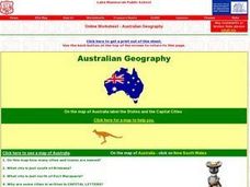
Australian Geography
In this map reading worksheet, students label a map of Australia by adding the names of states and cities. They answer eight questions about the map.
Curated OER
"Yarning" About Latitude and Longitude
Students identify various locations using latitude and longitude. In this map skills lesson, students use yarn and labels to create a "human globe." Students identify the Prime Meridian, the Equator, and Northern and Southern Hemisphere.
Curated OER
Summer Trip
Fourth graders search for information and directions to specific cities from their homes, figure cost of trip when given miles per gallon, distance, and cost per gallon of gas, develop outline budget for summer trip, and draw and label...
Other popular searches
- Labeling a Map
- Africa Map Labeling
- Midwest Map Labeling
- Geography Map Labeling
- Labeling a Map Continents
- Labeling Map Parts
- Labeling Parts of Map


