Curated OER
Sixth Grade Social Studies Quiz
In this social studies worksheet, 6th graders complete multiple choice questions about economics, climate, maps, and more. Students complete 15 questions.
Curated OER
World Projections
Students identify map projections and examine polar maps. In this map skills lesson, students use a flat world map to identify various projections and calculate the distances between locations by using a map scale.
Curated OER
Lesson Nine: Size and Scale
Students investigate scale as it is related to maps. In this map instructional activity, students read Jack and the Beanstalk by Carol North. Students then compare the setting in the story to a landscape picture map to help them study...
Curated OER
Establishment of Plainfield
Eighth graders analyze documents and maps of Plainfield, CT from different time periods, then, working in a small group, create a map for a giventime. In this Plainfield lesson, 8th graders read primary and secondary sources...
Curated OER
The Hopi Indians
Fourth graders read and look at maps of the Hopi Indians and compare and contrast their lives with the Hopi Indians. In this Hopi Indians lesson plan, 4th graders learn about different cultures and answer short answer questions.
Curated OER
Third Grade Social Studies Quiz
In this social studies worksheet, 3rd graders complete multiple choice questions about communities, maps, distances, and more. Students complete 11 questions.
Curated OER
The Sexton and the Compass
Students evaluate how movement patterns create and affect interdependence. They analyze the interactions within and between regions and engage in artistic inquiry, exploration, and discovery in collaboration with others. They design...
Curated OER
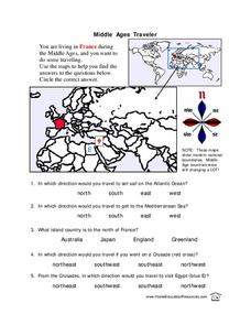
Middle Ages Traveler
In this map worksheet, pupils are given three maps of France to use to answer multiple choice questions. Students complete an activity from the perspective of a Middle Ages traveler.
Curated OER
Quadrilaterals
In this quadrilateral learning exercise, students use the street map of quadrilaterals to answer the six different questions. Students locate various parts of the street map as quadrilaterals.
Curated OER
Mapping a Temperature Field
Students measure and graph temperatures. In this temperature field lesson students use a map to measure and plot field values and construct isolines and interpret the results.
Curated OER
Pictures of Data
In this data instructional activity, students look at maps and charts and answer multiple choice questions about them. Students complete 10 questions.
Curated OER
Cardinal Directions
Students explore cardinal directions. In this social studies instructional activity, students create maps of home and school using the cardinal directions.
Curated OER
Globe Skills Lesson 6 The Louisiana Purchase
Students explore the Louisiana Purchase territory. In this geography skills lesson, students use map skills in order to plot and note latitude and longitude, measure scale distance, and locate landforms that were part of the Louisiana...
Curated OER
Trailblazers - Now and Then
Students, working in pairs, use maps to determine the most efficient routes between two cities. They research which route would have been used by early trailblazers. They present a first person account of one of the trailblazers place in...
Curated OER
Natural Features as a Resource
Learners investigate how land and water can meet basic needs. In this natural resources lesson plan, students locate water features on a Landscape Picture Map and describe how water is used to meet their needs.
Curated OER
Put Me in My Place: Using Alphanumeric Grids to Locate Places
Students practice locating points on a large wall grid and create and label a neighborhood map. In this geography lesson, students spell and discuss places as the teacher places them on the map. They discuss the concept of an...
Curated OER
This Land is Your Land
Young scholars consider the concept of borders and their development by looking at maps and documents. They create a presentation highlighting a current border dispute and propose solutions.
Curated OER
Fun with Summarizing
Students practice summarization by creating a story map. After reading Freckle Juice, students working in groups, create a story map of the main events of the story. Groups use their story maps to summarize a chapter of the story and...
Curated OER
Geography Words, Page 1
In this geography words and maps worksheet, students examine maps of North and South America. Students respond to 12 multiple choice questions regarding the maps.
Curated OER
Theatre Lesson Plan: Finding Your Way
Second graders identify story elements in familiar stories from their lives. In this story elements activity, 2nd graders act out familiar activities by following directions. Students read a story and discuss the story elements....
Curated OER
The Weather Page: Comparing Data
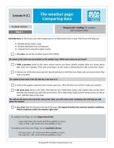
Students analyze data from maps. In this comparing data activity, students use comparative and superlative statements to draw comparisons among the weather in different American cities based on USA Today weather maps.
Curated OER
Name That Continent
Students practice locating the seven continents, four hemispheres, and four oceans using a large world map and a review song. They also import a world map to the Kid Pix computer program then type in proper labels on the map. There are...
Curated OER
Arthur's Tooth
Students practice their reading comprehension by reading a story in their class. In this story map lesson, students read the Marc Brown book Arthur's Tooth and discuss the story, characters and setting. Students create a story map based...
Curated OER
United States Map Quiz
For this online interactive geography quiz worksheet, students respond to 50 identification questions about the shapes of countries shown. Students have 5 minutes to complete the quiz.
Other popular searches
- Making Maps Geography
- Making Maps and Research
- Making Maps Using Technology
- Making Maps of History
- China, Making Maps
- Making Maps of Community
- Reading Making Maps
- Neigborhoods and Making Maps
- Making Maps Lesson Plans
- Making Map Scales
- Making Maps Usign Technology
- Making a Map Project


