Hi, what do you want to do?






Curated OER
Unesco: Germany: Hanseatic City of Lubeck
Lubeck - the former capital and Queen City of the Hanseatic League - was founded in the 12th century and prospered until the 16th century as the major trading centre for northern Europe. It has remained a centre for maritime commerce to...
Houghton Mifflin Harcourt
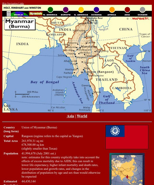
Holt, Rinehart and Winston: World Atlas: Myanmar (Burma)
Check out this map of Burma showing the major cities and the Irrawaddy River running the length of the country. There are also some quick facts listed about the country.
Curated OER
Etc: Maps Etc: Cities and Towns of the United States, 1898
A map from 1898 of the contiguous 48 states showing the distribution pattern of the major cities and towns at the time. The size of the dots indicate comparative populations. "Most of the manufacturing of the world is carried on in...
Curated OER
Etc: Maps Etc: The Great Powers and Imperialism in China, 1919
A map of China from 1919 showing the territorial possessions claimed in the country under European and Japanese imperialism after the Treaty of Shimonoseki (1895) between Japan and China, and the Conference of Paris, or Paris Peace...
Curated OER
Unesco: Russian Federation: Historical Centre of the City of Yaroslavl
Situated at the confluence of the Volga and Kotorosl Rivers some 250 km north-east of Moscow, the historic city of Yaroslavl developed into a major commercial centre from the 11th century. It is renowned for its numerous 17th-century...
Curated OER
Unesco: Turkmenistan: Parthian Fortresses of Nisa
The Parthian Fortresses of Nisa consist of two tells of Old and New Nisa, indicating the site of one of the earliest and most important cities of the Parthian Empire, a major power from the mid 3rd century BC to the 3rd century AD. They...
Curated OER
Unesco: Ecuador: Historic Centre of Santa Ana De Los Rios De Cuenca
Santa Ana de los Rios de Cuenca is set in a valley surrounded by the Andean mountains in the south of Ecuador. This inland colonial town (entroterra ), now the country's third city, was founded in 1557 on the rigorous planning guidelines...
Curated OER
Etc: Maps Etc: Highlands of Northern France During Wwi, October 20, 1918
A map of the French-German front movement during World War I in the highlands of northern France. The dashed red line shows the furthest advance of the German Army. The red line with crosses is the Hindenburg line, a system of defenses...
Curated OER
Educational Technology Clearinghouse: Maps Etc: France Plate Ii, 1920
Second in a series of maps of France from the 1920 Asprey's Atlas of the World, showing northern and northwestern France. This map is color-coded to show the Departments of the region, major cities and towns, primary railways, canals,...
Curated OER
Educational Technology Clearinghouse: Maps Etc: France Plate Iii, 1920
Third in a series of maps of France from the 1920 Asprey's Atlas of the World, showing southwestern France. This map is color-coded to show the Departments of the region, major cities and towns, primary railways, canals, rivers, coastal...
Curated OER
Educational Technology Clearinghouse: Maps Etc: Asia, 1904
A map of Asia from 1904 showing country boundaries at the time, major cities, rivers, lakes, deserts, terrain, and coastal features. This map shows the extent of the Russian Empire and Turkish Ottoman Empire in Asia, the Empire of Japan...
Curated OER
Educational Technology Clearinghouse: Maps Etc: France Plate Iv, 1920
Fourth in a series of maps of France from the 1920 Asprey's Atlas of the World, showing southeastern France and the Mediterranean Coast. This map is color-coded to show the Departments of the region, major cities and towns, primary...
Curated OER
Educational Technology Clearinghouse: Maps Etc: Nebraska, 1904
A map from 1904 of Nebraska showing the capital of Lincoln, major cities and towns, railroads, and rivers. "Nebraska - Territory organized in 1854; admitted to statehood in 1867. Area, 15,378 square miles, and population 1,067,000....

Other
Andorra
This is a map of Andorra that includes all of the major cities and rivers. Also provides a history of Andorra's government.
Curated OER
Educational Technology Clearinghouse: Maps Etc: North China, 1971
" North China includes the densely populated and intensively cultivated North China Plain, the loess-covered uplands of Shansi, northern Shensi, and eastern Kansu, and the sparsely populated, semiarid steppes of Inner Mongolia....
Curated OER
Educational Technology Clearinghouse: Maps Etc: South America, 1902
A map from 1902 of South America showing the national boundaries at the time. The map shows capitals, major cities, ports, railroads, canals, rivers, and coastal features. Railroads appear as red lines, with important trunk lines shown...
Curated OER
Educational Technology Clearinghouse: Maps Etc: Quebec, 1904
A map from 1904 of the populous portion of Quebec Province, showing major cities and towns, railways, rivers, lakes, and the frontier with Ontario. An inset map shows the eastern portion of the province along the Gulf of St. Lawrence,...
Curated OER
Etc: Maps Etc: Russia in Europe and Caucasia, 1920
A map of European Russia and the Caucasia at the end of World War I, showing province boundaries at the time, and the conjectural boundaries of the new states at the time the map was made given in red outline. These new states include...
Curated OER
Educational Technology Clearinghouse: Maps Etc: South America, 1921
A map from 1921 of South America showing the political boundaries of the time, major cities, railroads, terrain, rivers, and coastal features, and includes an insert map of the Galapagos Islands. " South America, the fourth largest grand...
Curated OER
Educational Technology Clearinghouse: Maps Etc: South America, 1906
A map of South America from 1906 showing the political boundaries of the time. The map shows capitals, major cities, ports, rivers, terrain and coastal features. An outline map of Pennsylvania at the same map scale is included to show...
Curated OER
Educational Technology Clearinghouse: Maps Etc: Switzerland, 1914 1919
A map from 1919 of Switzerland shortly after World War I, showing the Canton boundaries at the time, major cities and towns, railroads, lakes, rivers, and mountain systems of the region, and the frontiers with France, Italy, Austria, and...