Hi, what do you want to do?
Curated OER
Introducing The Gulf Stream
Sixth graders research the average temperatures of different places on Earth. For this earth science lesson, 6th graders explain how the sun's heat cause ocean movement. They discuss how temperature change affects the weather we experience.
Curated OER
Geology Word List
In this science worksheet, students review the vocabulary words for the separate categories related to the concept of geology.
Curated OER
The Gold Rush
Students identify the routes involved in the Gold Rush on a map. In this map skills lesson, students use a United States map to locate the routes used to travel to California during the Gold Rush. Students demonstrate how to use the map...
Curated OER
Design an Island
Students make a map of an imaginary island using the topographic symbols provided from a worksheet. Students place lakes, dwellins, reefs, etc. in areas where they would logically be located from understanding how the topography of an...
Curated OER
Magellan
Students identify the route of Magellan's voyage. In this map skills lesson plan, students use a globe to identify various coordinates where Magellan traveled.
Curated OER
World Climate Growing Zones
Students create a map showing where crops would be grown around the world. In this crops lesson plan, students show how the world climate would produce different parts of the world at different times. Students fill out worksheets.
Curated OER
Various 3 - Sentence Completions
In this sentence completion worksheet, students choose the correct word to use in the ten given sentences. This multiple choice worksheet is interactive.
Curated OER
Science Test B-Grade 4
In this grade 4 science test instructional activity, 4th graders complete a 30 question multiple choice quiz covering a variety of grade 4 concepts.
Curated OER
Couriers in the Inca Empire: Getting Your Message Across
Students explore how the Inca communicated across the bast stretches of their mountain realm.
Curated OER
MAP UNIT
First graders investigate how maps are used to identify different locations. They will also appreciate how there are different types of maps for their purposes. Finally students study how maps contain symbols that represent real places.
Curated OER
The Grand Canyon
In this geological processes worksheet, students use Google Earth to access pictures of the Grand Canyon. Students look at the layering of rock over time. Students complete 2 short answer questions.
Curated OER
Vocabulary Review: Completing Sentences
For this vocabulary worksheet, students check the word that will correctly complete a sentence, 7 sentences. Students choose from 4 words.
Curated OER
Location, Location, Location
Students use maps to locate their community in order to create a flip book.
Curated OER
Ocean Microstructure Lesson Plan
High schoolers explore the microstructure of the ocean by analyzing graphs created by Dr. Mike Gregg of the University of Washington Applied Physics Laboratory during the EPIC 2001 research cruise on the Ronald H. Brown NOAA vessel.
Curated OER
Class Letter of Introduction
Students follow guidelines to collectively draft a class letter that introduces their school to the rest of the participants in an online science experiment about water quality. They post the letter online as part of the larger unit.
Curated OER
Tracking the Movement of Sunspots
Students examine how the development of new technology has increased our knowledge of how the sun works. Students study sunspots through the use of solar imaging from satellite instruments.
wikiHow
Wiki How: How to Get Longitude and Latitude From Google Maps
This article will teach you how to get longitude and latitude for any given location using Google Maps.
Other
Boat Safe Kids: Longitude and Latitude
This website starts at the very beginning and explains how round globes are transferred to flat maps. Then they explain the use of longitude and latitude.
City University of New York
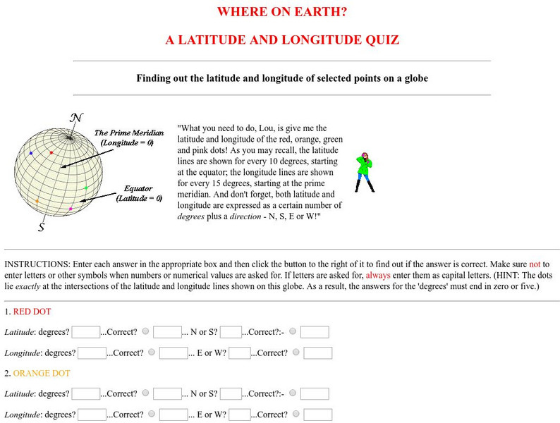
Virtual Geology: Where on Earth: A Latitude and Longitude Quiz
This quiz starts with select points on a globe. Students must determine the latitude, longitude, and direction for each point.
National Geographic
National Geographic: A Latitude/longitude Puzzle
Through examining maps students will be able to identify locations and characteristics of them based on latitude and longitude and infer what events might occur in the places.
ABCya
Ab Cya: Latitude and Longitude Treasure Hunt
Use the longitude and latitude clues to find the treasures on the map. The more treasures you find the more challenging it will be to find them.
The Franklin Institute
Franklin Institute: In Quiry: Minutes From Me: Latitude, Longitude and Vacations
An explanation of latitude and longitude along with a classroom activity that uses the location of students' vacation destinations for charting latitudes and longitudes.
Other popular searches
- Latitude and Longitude
- Latitude and Longitude Games
- Latitude and Longitude Maps
- Longitude and Latitude Game
- Longitude and Latitude Math
- Longitude and Latitude Lines
- Longitude and Latitude Grid
- Gps Longitude and Latitude
- Map Longitude and Latitude
- Maps, Longitude and Latitude
- Gaps Longitude and Latitude
- Finding Latitude and Longitude


