Owl Teacher
Latitude & Longitude
Here is a activity activity where learners mark the latitude and longitude coordinates of cities all over the world. There are 15 cities to identify, from Baghdad, Iraq to Warsaw, Poland and Anchorage, Alaska.
Ms. Catsos
Ancient Rome Map Worksheet
It wasn't just the great leaders of ancient Rome that shaped their civilization—the geography of the region played a major role as well. After first identifying major land masses, bodies of water, and city states on a map of Europe,...
Cornell University
Too Much of a Good Thing?
Continuing their study of beneficial insects, young entomologists discover where in the world some of these bugs are. By labeling, coloring, and using the scale on a map, pupils explore the territories and arrival of the Asian lady...
Curated OER
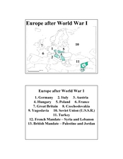
Europe after World War I
In this Europe after World War I map worksheet, students note the 11 regions of the Europe labeled on the map.
Curated OER
Plotting Earthquakes and Volcanoes
In this earthquakes and volcanoes worksheet, students are given the latitude and longitude of earthquakes and volcanoes and they plot them on a world map. They answer questions based on their results.
Curated OER
The World At Your Fingertips
In this the world at your fingertips worksheet, students bring in 5 items from home that are not made in the U.S., then complete a chart, indicate on a map and answer 6 questions about imported items.
Curated OER
Living In the UK
In this geography activity, students complete activities on 16 worksheets pertaining to the geography and culture of the countries of the United Kingdom. This is intended for ESL students.
Curated OER
Europe 1914
In this Europe 1914 map worksheet, learners note the 9 regions of the Europe labeled on the map and their relevance to World War II.
Curated OER
Where in the World? Oceans & Continents
For this geography worksheet, students answer 6 questions using a coded map as a reference, then students identify labeled geographic features.
Curated OER
Across the United States- Home Learning Activity
In this home-school United States map worksheet, students work with a family partner as they study a map of the United States. They talk about the states they have visited, play a game by giving each other clues about states, and write...
Curated OER
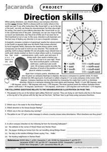
Direction Skills
In this geography worksheet, students read an excerpt on what directions tell someone. They respond to 6 short answer questions related to the neighborhood illustration found on the second page of the worksheet.
Curated OER
Tourism in Northern Ireland
In this tourism worksheet, students label pictures of tourist destinations with the name of the country they are located in, write sentences about pictures showing damage caused by tourists, identify locations on a map, and fill in...
Curated OER
The Roman Empire-Map Activity
In this Roman Empire worksheet, students complete a map activity in which they label and color civilizations, countries and physical features as instructed. There are no maps included.
Curated OER
All Kinds of Homes
In this types of homes worksheet, students draw and label four different types of homes in the four box provided for them on the worksheet. Students then choose one and explain why they would or wouldn't want to live there to a friend.
Curated OER
Earth's Features
In this geography worksheet, students label a map of the world with the Arctic Circle, Tropic of Capricorn, Tropic of Cancer, Equator, North Pole, South Pole, and the Antarctic Circle.
Curated OER
Types of Home
In this home types worksheet, students label each of the types of homes pictured by listing the words given in the word bank beneath the pictures.
It's About Time
Plate Boundaries and Plate Interactions
How does the Earth continually repair itself? Explore the answer to this question, and others, with a unit on plate boundaries and interaction. Pupils classify the types of movement at plate boundaries and identify the distribution of...
Super Teacher Worksheets
My Explorer Report
This is the perfect resource to accompany your class project on famous explorers! Learners detail basic information about their chosen explorer, his/her main events of exploration and means of transportation, and finally, illustrate the...
Curated OER
Food and Countries Match
Beijing duck? Italian pizza? Japanese sushi? Language learners match food words with their country of origin. An answer key is included with the colorfully illustrated worksheet.


